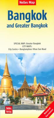
Stadsplattegrond Bangkok en omgeving | Nelles Verlag

0
Goede stadskaart van Bangkok en omgeving. Aan beide kanten bedrukt. Met veel toeristische aanduidingen als culturele bezienswaardigheden en aanduidingen van bijvoorbeeld de grotere hotels. Prima leesbare kaart. Bangkok on a double-sided map from Nelles combining an indexed street plan of the city’s central districts at 1:15,000 with a more general...

Verkopers met dit product

Verkoper
Bezorging
Prijs
DeZwerver.nl logo
DeZwerver.nl
2,95
11,95

Anderen bekeken ook

Stadsplattegrond Bangkok en omgeving | Nelles Verlag
Goede stadskaart van Bangkok en omgeving. Aan beide kanten bedrukt. Met veel toeristische aanduidingen als culturele bezienswaardigheden en aanduidingen van bijvoorbeeld de grotere hotels. Prima leesbare kaart. Bangkok on a double-sided map from Nelles combining an indexed street plan of the city’s central districts at 1:15,000 with a more general plan of the capital with its outer suburbs presented at 1:75,000. Both plans highlight numerous places of interest.   On one side the main, indexed plan covers the city’s inner districts showing public transport routes: metro and skytrain lines with stations, bus routes with line numbers, and express boat service along the river. Public buildings, including selected hotels, are clearly marked and named, and shopping centres or market streets are indicated. The main centre of tourist accommodation, Banglamphoo - Khao San Road area, is also shown in greater detail on a small enlargement.   On the reverse a more general plan at 1:75,000 covers …
11,95
Stadsplattegrond Bangkok | Borch
Borch Bangkok is een duidelijke, geplastificeerde plattegrond van het centrum met informatie over openbaar vervoer en bezienswaardigheden. Inclusief straatnamenregister. Our soft-laminated folded map of Bangkok shows: Bangkok City 1:14 000, Wat Phra Kaeo & Royal Grand Palace 1:6 000, Bangkok & Region 1:100 000, Public Transport Bangkok, Top 30 Sights, Thailand administrative and time zones. Borch Maps are easy to fold, durable and water-repellent with a wipeable surface. Borch Maps show hotels, museums, monuments, markets, public transport, top sights and points of interest, useful statistics, conversion charts for temperatures, weights and measurements, climate charts showing temperatures, sunshine hours, precipitation and humidity, overview maps, time zones, and much more...   Krung Thep Maha Nakhon (Bangkok) on the Chao Phraya river is the capital city of Thailand and the country's economic center. It is one of the most populous cities in the world with its number of inhabitants ve…
9,95
Stadsplattegrond Canberra en omgeving | Hema Maps
Stadsplattegrond van Canberra met een omgevingskaart. Inclusief  register.   A map that has the Canberra suburbs (1:60,000) on one side and the Canberra city, Canberra region (1:850,000) and ACT (1:375,000) maps on the other.    Also included is an information section on Canberra's tourist attractions with necessary tourist attractions attached.   Features of this map include:   Highways,major roads and local streets Points of interest Accommodation Parks Caravan Parks 24Hour Fuel Railway stations Suburbs Suburbs Index Shopping centres Theatres/Cinemas Sporting venues CBD Map ACT Map
14,50
Stadsplattegrond City map Bangkok | Lonely Planet
De stadsplattegronden van Lonely Planet zijn uitgevoerd op scheur- en watervast papier, zijn lichtgewicht en kennen een handig formaat. Het centrum van de stad is in heldere kleuren in beeld gebracht met straatnamen, bezienswaardigheden en symbolen voor openbaar vervoer. Op de achterzijde staat informatie over de toeristische hoogtepunten en in de meeste gevallen een schematische plattegrond van het openbaar vervoer. Met een register. Durable and waterproof, with a handy slipcase and an easy-fold format, Lonely Planet's Bangkok City Map is your conveniently sized passport to travelling with ease. Get more from your map and your trip with images and information about top city attractions, walking tour routes, transport maps, itinerary suggestions, an extensive street and site index, and practical travel tips and directory. With this easy-to-use, full-colour navigation tool in your back pocket, you can truly get to the heart of Bangkok, so begin your journey now!   Durable and waterp…
10,95
Stadsplattegrond Darwin en omgeving | Hema Maps
Stadsplattegrond van Darwin en de directe omgeving. Inclusief index. Offering maps of the region, suburbs and Darwin’s CBD. Containing the entire city with primary, secondary and tertiary road patterns, city centre distance markers on major roads and postcode and road numbering, these maps are easy and helpful to use, making them appropriate for a wide range of users. Easy to use CBD map Suburban map Regional map Postcodes Points of interest Fully indexed
14,50
Stadsplattegrond Jakarta en omgeving | ITMB
Kaart van het centrum op gedetailleerde schaal en een kaart op de achterzijde van de regio en voorsteden op een schaal van 75.000. Indonesia is emerging quickly as one of the power-houses of Asia. Jakarta is a huge urban area, with a charming city centre. This double-sided map shows Greater Jakarta on one side, with its expressways and inter-urban train network and is, in my opinion very useful to business visitors to the city. It includes the airport, the city centre, the enormous soccer stadium (worth a visit), and the roads connecting the different neighbourhoods of this spread-out city. The other side concentrates on the central core of Jakarta, which is where most visitors would spend most time. Road and rail connections are clearly shown, as well as a good range of embassies, museums, hotels, gas stations, religious buildings, hospitals, and touristic attractions. Asian cities tend not to be well-mapped; the last map of the city that I recall was done about ten years ago, so thi…
13,95
Wegenkaart - landkaart - Stadsplattegrond Thailand zuid South - Bangkok | ITMB
Duidelijke wegenkaart met op de ene zijde de kaart van Bangkok op een goede schaal met veel toeristische informatie. De andere kant heeft het hele zuiden van Thailand .   Bangkok is a very interesting city, with many temples, pagodas, and historic buildings. It is also an airline hub and, as a result of not being a member of IATA, is a bargain-lover city for lower-cost airfares. This updated edition includes the new airport, recently-completed transit lines, and additional information for embassies. In this edition, we have combined our city map with a travel map for the southern half of the country, which means the peninsula connecting to Malaysia and including the most-visited parts of Thailand, the beach resorts located in the vicinity of Phuket. We have also upgraded it to plastic paper, both for the tropical humidity and for durability.    Map size: 27*39"   Legend Includes: Roads by classification, motorway, expressway, provincial highway, river, national park, waterfall, touris…
13,95
Reisgids Bangkok | Rough Guides
Zeer goede reisgids voor zowel de georganiseerde maar vooral voor de zelfstandige reiziger. Boordevol informatie over reizen, slapen, eten, maar ook musea en cultuur. Voor Europese landen meestal completer en beter dan de Lonely Planet ! Ideal for independent travellers, this guidebook to Bangkok, written by destination experts, combines must-see sights with hidden gems and offers essential tips for both planning and on-the-ground adventures. It's sustainably printed to ensure environmental responsibility.   Inside this Bangkok travel book, you'll find:   Regional deep dive – coverage of key regions, offering a rich selection of places and experiences, and honest reviews of each one Itinerary samples – designed for various durations and interests Practical information – tips on how to get there and get around, use public transport, beat the crowds, save time and money, travel responsibly and more Expert recommendations – insider advice on where to eat, drink, and stay, alongside tips …
23,50
Reisgids Bangkok | Lonely Planet
De perfecte reisgids voor zowel de georganiseerde als de zelfstandige reiziger. Naast een algemene inleiding van de stad vol met praktische informatie over hoe je er het beste kunt reizen: slapen, eten, vervoer, excursies ... alles kun je er in vinden. Lonely Planet's local travel experts reveal all you need to know to plan the trip of a lifetime to Bangkok.   Discover Bangkok's most popular experiences and best kept secrets - neighbourhood by neighbourhood - from visiting Wat Suthat to marvel at one of Thailand's biggest Buddhas to taking a sunset sightseeing river cruise from Sathron/Central Pier, and indulging your senses at Bang Rak's historic Spice Alley.   Build a trip to remember with Lonely Planet's Bangkok travel guide:   Our classic guidebook format provides you with the most comprehensive level of information for planning multi-week trips Updated with an all new structure and design so you can navigate Bangkok and connect experiences together with ease Create your …
24,95

Klanten-reviews van Stadsplattegrond Bangkok en omgeving | Nelles Verlag

Er zijn nog geen beoordelingen voor dit productBen jij de eerste die een review plaatst?

Meer over Stadsplattegrond Bangkok en omgeving | Nelles Verlag

Productomschrijving

Goede stadskaart van Bangkok en omgeving. Aan beide kanten bedrukt. Met veel toeristische aanduidingen als culturele bezienswaardigheden en aanduidingen van bijvoorbeeld de grotere hotels. Prima leesbare kaart.

Bangkok on a double-sided map from Nelles combining an indexed street plan of the city’s central districts at 1:15,000 with a more general plan of the capital with its outer suburbs presented at 1:75,000. Both plans highlight numerous places of interest.   On one side the main, indexed plan covers the city’s inner districts showing public transport routes: metro and skytrain lines with stations, bus routes with line numbers, and express boat service along the river. Public buildings, including selected hotels, are clearly marked and named, and shopping centres or market streets are indicated. The main centre of tourist accommodation, Banglamphoo - Khao San Road area, is also shown in greater detail on a small enlargement.   On the reverse a more general plan at 1:75,000 covers the city with its outer suburbs, highlighting main traffic arteries, including access to the international airport. Metro, skytrain and express boat lines are marked, plus the suburban railway lines with station names. In addition to information described above, the plan also gives names of numerous industrial and educational establishments, etc.

Greater Bangkok 1 : 75.000

Banglamphoo / Khao San Road 1 : 7.900
City Centre 1 : 15.000


Productinformatie

    Verken gerelateerde categorieën

    Webshop.nl maakt gebruik van cookies. Ga je verder op onze website, ga dan akkoord met het plaatsen van cookies en de verwerking van deze data door ons en vermelde partners.