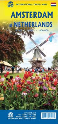
Stadsplattegrond Amsterdam / Nederland | ITMB

0

Verkopers met dit product

Verkoper
Bezorging
Prijs
DeZwerver.nl logo
DeZwerver.nl
2,95
12,95

Anderen bekeken ook

Stadsplattegrond Manila & Luzon | ITMB
Stadsplan Manila   Manila on a double-sided indexed street plan, with a diagram of the city’s metro network. The plan divides the city north/south, roughly along the upper part of the Pasig River, with a generous overlap between the two sides. Coverage of the northern side extends to Caloocan City - San Francisco del Monte and inland to the Cubao district. The southern side includes the Legaspi Vill and the Ayala Centre area. The plan clearly shows the city’s main traffic arteries, indicating one way streets, car parks and locations of petrol stations. Metro or railway stations and bus terminals are marked and in the port pier numbers are also shown.
14,50
Stadsplattegrond Amsterdam | Borch
Amsterdam Borch is een duidelijke, geplastificeerde plattegrond van het centrum met informatie over openbaar vervoer en bezienswaardigheden. Inclusief straatnamenregister.   Our soft-laminated folded map of Amsterdam shows: Amsterdam 1:11 000, Central Amsterdam 1:6 000, Greater Amsterdam 1:100 000, Public Transport Amsterdam, Top 30 Sights and The Netherlands administrative. Borch Maps are easy to fold, durable and water-repellent with a wipeable surface. Borch Maps show hotels, museums, monuments, markets, public transport, top sights and points of interest, useful statistics, conversion charts for temperatures, weights and measurements, climate charts showing temperatures, sunshine hours, precipitation and humidity, overview maps, and much more.   The capital city of the Netherlands is also its financial and cultural center, although not its seat of government or monarchy (which is The Hague). Once the center of the world economy, Amsterdam is today renowned as one of the most roman…
9,95
Stadsplattegrond Vancouver & Greater Vancouver | ITMB
Stadsplattegrond van Vancouver met een extra inzet op kleinere schaal van het centrum. Met register. Waterproof! ITMB first published our own map of Vancouver six editions and twenty years ago. Each time we update, we're surprised at how much change has taken place. This is a double-sided map, with the city on one side and the metropolitan area on the other side. Like many North American cities, Vancouver consists of several separate urban areas that have merged together physically but not politically. Greater Vancouver's population is 2,500,000, most of which consists of residential areas. The 'regional' side is where the growth in population is taking place (about 100,000 people move to Vancouver each year) and this is where noticeable developments are taking place - the new South Perimeter Road following the Fraser River eastwards, the new Port Mann toll bridge, the new toll Golden Ears toll bridge across the Fraser. None of this will make sense to non-locals, but since most of our…
13,95
Stadsplattegrond Letland - Latvia & Riga | ITMB
Een degelijke kaart met aanduidingen van o.a. nationale parken, vliegveld, benzinepomp, dirt-roads en plattegrond van hoofdstad. Als overzichtskaart goed te gebruiken. This is a brand new mapping area for ITMB. We have had a map of Riga for years, but not the country of Latvia, which now graces one side of the sheet while Riga occupies the other. The country is larger than one might think, touristically friendly, historically significant, and strategically important. Wedged between Estonia on the north and Lithuania on the south, Latvia tends to be a fast north-south route through the Baltic States, but its strength lies in being an east-west country with a very long coastline. Riga itself is a very interesting city, and our map shows it to perfection. This map would be very useful for anyone going to the Baltic Sea countries and firs very well with our companion map of Estonia/Talinn
13,95
Stadsplattegrond Singapore & Malay Peninsula | ITMB
Goede stadsplattegrond van Singapore. Met register en suburban treinsysteem. De echt verre buitenwijken van deze megastad staan er niet op. Aan de achterzijde een overzichtskaart van het vasteland van Maleisië met een schaal van 730.000 Singapore is Asia as it should be: clean, modern, well-governed, efficient, and attractive.  In this edition, which technically should be a first edition due to the transformation of the map into a double-sided one, includes for the first time, our detailed map of the part of Malaysia known as the Malay Peninsula, the ‘mainland’ portion of the country. Singapore and Malaysia are joined together by two motorway crossings and a train operated by Malaysian Railways. Side one of our map concentrates on the urbanized portion of Singapore and its attractions, with a large and detailed inset map of the country of Singapore. Side two covers all of the mainland portion of Malaysia to the Thai border and includes a large inset map of Kuala Lumpur. Motorways are …
13,95
Stadsplattegrond Tokio & Kanto / Chubu | ITMB
Tokyo is one of the most populous cities in the world, so it is very difficult to capture all of it on one map sheet. The areas of touristic interest tend to exist in a relatively small portion of the metropolis, essentially from the Shibuya and Shinjuku shopping areas in the west to the Asakusa temple complex in the east. All the subway lines are shown, as well as stations. The rail lines passing through the city are numerous, but well-portrayed, including the monorail going to Haneda Airport and the main Shinkensen Terminal. The imperial palace is prominently shown, although not open for tourists. Tokyo tends to be a bit overwhelming, so having a good map is essential. This map includes an inset of the Narita International Airport and train routes into Tokyo, as well as a large inset showing the spaghetti-like network of subway/rail lines serving Tokyo. The reverse side of the sheet is essentially a detailed map of central Japan as far west as Nagoya and north to Yamagata, offering …
13,95
Stadsplattegrond Havana - Cuba Central | ITMB
Op één zijde van de kaart staat een heldere stadsplattegrond van Havana (schaal 1:12.000) met register en op de andere zijde het centrale deel van Cuba (schaal 1:420.000) met een uitsnede van Varadero (schaal 1:21.000), Trinidad (schaal 1:12.000) en Cienfuegos (schaal 1:20.000). Overzichtelijke kaart met onder andere stranden, hotels en dirtroads aangegeven. Legend Includes: Roads by classification, sands, swamps, reefs, parks, point of interests, diving areas, beaches, viewpoints, caves, dams, ports, hotels, gas stations, camping, airports, airfields, shipwrecks, lighthouses, mines, attractions, and more.
13,95

Klanten-reviews van Stadsplattegrond Amsterdam / Nederland | ITMB

Er zijn nog geen beoordelingen voor dit productBen jij de eerste die een review plaatst?

Meer over Stadsplattegrond Amsterdam / Nederland | ITMB

Productinformatie

    Verken gerelateerde categorieën

    Webshop.nl maakt gebruik van cookies. Ga je verder op onze website, ga dan akkoord met het plaatsen van cookies en de verwerking van deze data door ons en vermelde partners.