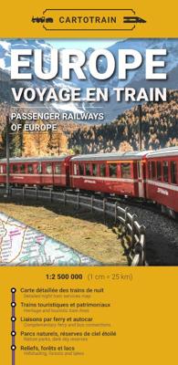
Spoorwegenkaart Europe Voyage en train Cartotrain | Europa | Cartotrain

0

Verkopers met dit product

Verkoper
Bezorging
Prijs
DeZwerver.nl logo
DeZwerver.nl
2,95
18,95

Anderen bekeken ook

Spoorwegenkaart Railmap Europe - Treinkaart Europa | Kümmerly & Frey
Duidelijke kaart van Europa waarop de verschillende spoorwegen staan ingetekend. Er wordt onderschied gemaakt in de soort treinen, al of niet electrisch, diesel of anders. De kaart is te grof om alle stations te vermelden, het is een ideale kaart om je treinreis te plannen.  Large physical map of Europe with political boundaries, showing the railway network graded into 18 different types of lines. The base map with very fine cartography clearly shows various mountain ranges. Coverage extends to beyond the Urals and the eastern side of the Caspian Sea, large part of the Middle East with most of Iraq and Iran, and the coast of North Africa, and includes railway lines in all these areas.   Country and geographical names are in English and cities in local languages with, where appropriate, English versions. In countries using other alphabets, larger cities are additionally given in Cyrillic, Greek, Arabic, etc.   The railway network distinguishes 18 different types of lines, from new high…
14,95
Spoorwegenkaart Europa - Europe Railway and Road | ITMB
Spoorwegen kaart van het Europese continent in kleur. Schaal 1:3,350,000. Toont spoorlijnen, snelwegen, secundaire wegen en andere wegen, veerboten en belangrijke scheepvaartdiensten; internationale grenzen, de grenzen van de gebieden met reisbeperkingen; bergen met de hoogte in meters. Met index van plaatsen; grafiek toont de vlag van elk land, hoofdstad, de bevolking en de oppervlakte. Schaal 1:3,350,000. Afstanden in kilometers en mijlen. Gedrukt op twee zijden. This is a significantly updated map of the rail network of Europe from Moscow west to Lisbon and north to Narvik. We have added new fast-train lines and removed some of the older ones that are now just used for freight. Rail travel has always been a popular way to travel around western Europe. Eurail passes and drive-and-ride options encourage visitors to get out of their cars and enjoy seeing the countryside from modern train windows. Legend Includes: High speed railways, Europe road network, Motorways, Ferries, internatio…
13,95
Treinreisgids Train Travel in Europe - Europa | Lonely Planet
Looking for a sustainable and stress-free way to explore Europe? Hop on board the continent's railway network with this ultimate guide to train travel. Whether you want to take it slow on the scenic route or make the most of the newest high-speed services to get straight to your destination, Lonely Planet's experts show you how to plan your journey. Packed with detailed gatefold route maps and insider tips, we cover everything from how to piece together a long-distance trip to the must-see stops and best ways to book value-for-money tickets. As airlines cut back flights and airfares rise, now is the perfect time to take advantage of the increasing overnight services and flexible fares being offered. We also reveal the quirks of different operators and countries, such as luggage allowances, rules and regulations, and what facilities are on board. If you're looking for a more eco-friendly, convenient - and sometimes quicker - way to get from A to B as you travel throughout the continent…
27,95
Spoorwegenkaart The British Isles by Train and Ferry | Cosmographics
Plan your journey and explore the British Isles by train and ferry. This attractive, detailed map shows how the rail network, along with ferries to the more isolated areas, allows you to travel to places right across the British Isles and take in the beautiful scenery. The map clearly shows National Parks, Areas of Outstanding Natural Beauty, forest and woodland areas and the Heritage Coast in England and Wales, much of which is accessible by train and ferry. The rail network includes seasonal and heritage railways. There is also a more detailed map of the London National Park City, the world’s first National Park City. Designed to be fully inclusive and accessible for everyone, including those with colour vision deficiency (CVD).   Map includes:   Passenger rail network with the majority of stations. Seasonal and heritage railways Ferry routes National Parks Areas of Outstanding Natural Beauty Main forest and woodland areas Heritage coast in England and Wales Formaat:  74.5cm …
19,50
Spoorwegenkaart Europe Western Railroad & Road | ITMB
Spoorwegen kaart van West Europa in kleur. Schaal 1:2,500,000. Toont spoorlijnen, snelwegen, secundaire wegen en andere wegen, veerboten en belangrijke scheepvaartdiensten; internationale grenzen, de grenzen van de gebieden met reisbeperkingen; bergen met de hoogte in meters. Met index van plaatsen. Schaal 1:2,500,000. . Gedrukt op twee zijden. This is a new title for ITMB. It focusses on the western half of the European land mass at a much better scale than would be possible for all of Europe. Even at this scale, showing the rail lines and the major roads results in a map with a lot of information on it, but it meets the needs of those travelling around Europe by rail, which is its primary market. It can also be used by those driving, although it would be better for vehicle users to rely on individual country maps. Side 1 covers the British Isles, the Low Countries, Germany, Denmark, the Czech Republic, most of Poland, and southern Scandinavia. The second side covers the Iberian Peni…
13,95
Spoorwegenkaart Eastern Europe Railway & Road | ITMB
Spoorwegen kaart van Oost Europa in kleur. Schaal 1:2,600,000. Toont spoorlijnen, snelwegen, secundaire wegen en andere wegen, veerboten en belangrijke scheepvaartdiensten; internationale grenzen, de grenzen van de gebieden met reisbeperkingen; bergen met de hoogte in meters. Met index van plaatsen. Schaal 1:2,600,000. . Gedrukt op twee zijden. ITMB is pleased to announce the release of the final regional map covering Europe at an enhanced scale. Europe may be small in comparison to Canada, but it is densely populated and difficult to map as a continent while providing detail. Eastern Europe used to be defined as everything behind the Iron Curtain during the Cold War, but now it encompasses everything east of Germany and Switzerland, which means that this map covers Italy, Greece and the Balkan countries, the Central European countries of Romania and Hungary and most of Ukraine, Poland and the three Baltic states, and western Russia as far east as Volgograd, as well as much of Turkey.…
13,95
Spoorwegenkaart Rail Map of Europe | Collins
ooking for your next adventure? This rail map of Europe is the perfect planning and travel companion   Ever wanted to wake up in Paris, have lunch in Geneva and fall asleep in Rome? By using Europe's extensive train network, that dream can be a reality!   With a durable card-cover, clear mapping and essential travel information and inspiration, there's no better way to plan your plane-free journey around Europe. Showing all the essential railways across the continent, differentiating between high-speed and normal lines for ease of use, this two-sided map provides full coverage of mainland Europe and the United Kingdom.   Additional features include:   Suggested itineraries and routes as sources of inspiration Information about each country accompanied by beautiful pictures Tips for European travel, including information about ticket types and passes, currencies, train company websites, and safety information for travellers A country-by-country station finder section to ma…
18,95
Reisgids Europe - Europa | Eyewitness
DK Eyewitness Travel Guide: Europe will lead you straight to the best attractions this diverse continent has to offer, from the majestic peaks of the Alps to the turquoise waters of the Mediterranean. This newly updated guidebook is packed with information on the culture, history, architecture, and art of the continent, in addition to the best of Europe's gardens, beaches, cathedrals, castles, and shopping. DK's insider travel tips and essential local information will help you discover Europe your way, whether you want to explore the luscious green landscape of Ireland, relax on a beach in Greece, or both. Discover DK Eyewitness Travel Guide: Europe.    • Detailed itineraries and "don't-miss" destination highlights at a glance.    • Illustrated cutaway 3-D drawings of important sights.    • Floor plans and guided visitor information for major museums.    • Local drink and dining specialties to try, things to do, and places to eat, drink, and shop by area.    • Area maps marked with si…
27,95

Klanten-reviews van Spoorwegenkaart Europe Voyage en train Cartotrain | Europa | Cartotrain

Er zijn nog geen beoordelingen voor dit productBen jij de eerste die een review plaatst?

Meer over Spoorwegenkaart Europe Voyage en train Cartotrain | Europa | Cartotrain

Verken gerelateerde categorieën

Webshop.nl maakt gebruik van cookies. Ga je verder op onze website, ga dan akkoord met het plaatsen van cookies en de verwerking van deze data door ons en vermelde partners.