Meer Blast

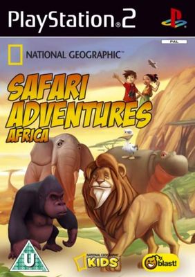
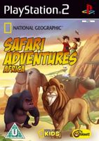
Safari Avonturen Afrika (National Geographic)

0
Ga in National Geographic Safari Adventures Africa op een virtuele safari. Ontdek dieren en landschappen. Leer in een spannend avontuur alles over het prachtige continent Afrika. Speel meer dan 90 missies met uniek puzzles....

Verkopers met dit product

Webshop
Bezorging
Prijs
Nedgame.nl logo
Nedgame.nl
1 dag
3,49
6,99

Anderen bekeken ook

Wandkaart Zuid Amerika, politiek, 91 x 117 cm | National Geographic
Staatkundige  kaart van Zuid-Amerika (in kleur). De kaart wordt verzonden in een koker.  This classic map of South America shows political boundaries, place names, airports, major roads and highways, and other geographic features for the entire continent. 36 x 46 inches (approx). Scale size: 1:7,105,000. Founded in 1915 as the Cartographic Group, the first division of the National Geographic Society, National Geographic Maps has been responsible for illustrating the world around us through the art and science of mapmaking. Today, National Geographic Maps continues this mission by creating the world s best wall maps, recreation maps, atlases, and globes which inspire people to care about and explore their world. All proceeds from the sale of National Geographic maps go to support the Society s non-profit mission to increase global understanding and promote conservation of our planet through exploration, research, and education.
49,95
Reisgids - Natuurgids Game Parks of South Africa - Zuid Afrika wildparken | Rough Guides
Een prachtige reisgids met een uitgebreid overzicht van de Wildparken in Zuid Afrika: heel veel praktische informatie over accommodaties, beste reistijd, hoe te verplaatsen en ga zo maar door. Achterin een kleine natuurgids met de meest voorkomende soorten en ook een mooi overizcht van de diersporen die je tegen kunt komen.    Discover the Game Parks of South Africa with this comprehensive and entertaining travel guide, packed with practical information and honest recommendations by our independent experts. Whether you plan to take a jeep safari, tick off the big five or sleep in a camp in the lap of luxury, The Rough Guide to the Game Parks of South Africa will help you discover the best places to explore, eat, drink, shop and sleep along the way.   Features of this travel guide to Game Parks of South Africa: Detailed regional coverage: provides practical information for every kind of trip, from off-the-beaten-track adventures to chilled-out breaks in popular tourist areas Honest and…
24,95
Magneetbord Middle East - Midden Oosten | National Geographic
Magneetbord - Wandkaart van het Midden Oosten, met o.a. Afghanistan - Pakistan - National Geographic wandkaart geplastificeerd - Afmeting ca 76 x 58cm    National Geographic Maps' recently updated wall map of the Middle East region, formerly titled Afghanistan/Pakistan and the Middle East.   Includes updated place names and the addition of significant locations currently in the news, such as Marjah, Afghanistan. This wall map covers a broad geographic area ranging from northern Africa through the Middle East to the western edge of China and India.   Includes complete coverage of Afghanistan, Pakistan, Tajikistan, Iran, Iraq, Kuwait, Syria, Israel, Jordan, Lebanon, Saudi Arabia, Qatar, Bahrain, United Arab Emirates, Yemen, Oman, Cyprus, and Eritrea.   Also includes parts of India, China, Kyrgyzstan, Uzbekistan, Turkmenistan, Azerbaijan, Armenia, Turkey, Egypt, Sudan, Ethiopia, and Djibouti. Features thousands of place names, accurate political boundaries, archeological sites, and major…
189,-
Reisgids Zambia Safari Guide: Luangwa Valley • Lower Zambezi • Victoria Falls | Bradt Travel Guides
Zeer goede gids voor Zambia en betrouwbaar alternatief voor de Lonely Planet. Nog completer! Zelfde soort informatie als de Lonely Planet: vol met praktische feiten en achtergronden. Voor Afrikaanse landen zijn de Bradt guides veruit de meest complete reisgidsen. For over 25 years Bradt's Zambia Safari Guide has been widely acknowledged as the best guidebook to this African country, and it is now the only dedicated guide to Zambia's world-renowned safari destinations. Combining in-depth reviews of lodges, camps and other accommodation (from a stately home to a contemporary woven treehouse), detailed descriptions of safari locations and operators, extensive practical details, local insights, a brand new 48-page colour wildlife guide and curated coverage of the main access points of Lusaka and Livingstone, this is the ‘must-have' guidebook to travel planning and exploring the country's wildlife-rich safari regions.   Lying in the heart of the continent, Zambia is deepest, darkest Africa…
27,95
Wandkaart Afrika, politiek & antiek, 61 x 78 cm | National Geographic
Mooie wandkaart van Afrika, staatkundig, met rustig kleurgebruik en helder kaartbeeld, Ondanks het wat kleiner formaat staan er toch heel wat topografische details op vermeld.    Kaart is up-to-date, alleen Zuid Sudan wordt niet als een apart land weergegeven.   Our executive-style political map of Africa features country boundaries, place names, bodies of water, airports, major highways and roads, and much more. Astounding detail and boardroom quality make this map excellent for reference in your home or office.   The map presents Africa at 1: 14,244,000 and coverage includes the whole of the Mediterranean Basin, extending north to London. Islands in the Atlantic and the Indian Ocean are included on a separate inset. The base map has relief shading to show the continent’s topography, with additional graphics indicating deserts, swamps, salt flats, etc. The map shows the names of the main geographic features such as mountain ranges, deserts, peaks etc. Heights are given in metres, exc…
31,95
Wandkaart Afrika, politiek, 91 x 118 cm | National Geographic
Mooie wandkaart van Afrika, staatkundig, met rustig kleurgebruik en helder kaartbeeld, Ondanks het wat kleiner formaat staan er toch heel wat topografische details op vermeld.    The map presents Africa at 1: 9.328.000 and coverage includes the whole of the Mediterranean Basin, extending north to London. Islands in the Atlantic and the Indian Ocean are included on a separate inset. The base map has relief shading to show the continent’s topography, with additional graphics indicating deserts, swamps, salt flats, etc. The map shows the names of the main geographic features such as mountain ranges, deserts, peaks etc. Heights are given in metres, except for Kilimanjaro, shown in both metres and feet. In the Congo basin many of the tributaries are named.    Country boundaries are shown in contrasting colours. All place names are in English, except for selected cities such as Cairo, Tripoli or Algiers where the original names are shown first (El Quahira, etc) with the English equivalents …
45,95
Wegenkaart - landkaart Africa - Afrika | National Geographic
  • Waterproof • Tear-Resistant • Reference Map   Expertly researched and designed, National Geographic's Africa Flags & Facts Map is the authoritative map of Africa by which other reference maps are measured. The map side includeds a political map showing countries, cities and other landmarks and a physical map shows the landforms such as mountain ranges and rivers.   Clearly defined boundaries, major cities, and physical features Hundreds of place names carefully placed to maintain legibility in heavily populated areas Includes Africa and adjacent regions within Europe and Asia Detailed physical map of Africa with mountain ranges, plains, lakes, and rivers Flags and facts with detailed information about cultural and physcial attributes Printed in the U.S.A. on extremely durable, waterproof, and tear-resistant material This Reference Map is printed on durable synthetic paper, making it waterproof, tear-resistant and tough — capable of withstanding the rigors of any kind of use in the…
17,50
Wandkaart Middle East - Midden Oosten 76 x 58 cm | National Geographic
Wandkaart van het Midden Oosten, met o.a. Afghanistan - Pakistan - National Geographic wandkaart geplastificeerd - Afmeting ca 76 x 58 cm  National Geographic Maps' recently updated wall map of the Middle East region, formerly titled Afghanistan/Pakistan and the Middle East. Includes updated place names and the addition of significant locations currently in the news, such as Marjah, Afghanistan. This wall map covers a broad geographic area ranging from northern Africa through the Middle East to the western edge of China and India.   Includes complete coverage of Afghanistan, Pakistan, Tajikistan, Iran, Iraq, Kuwait, Syria, Israel, Jordan, Lebanon, Saudi Arabia, Qatar, Bahrain, United Arab Emirates, Yemen, Oman, Cyprus, and Eritrea.   Also includes parts of India, China, Kyrgyzstan, Uzbekistan, Turkmenistan, Azerbaijan, Armenia, Turkey, Egypt, Sudan, Ethiopia, and Djibouti. Features thousands of place names, accurate political boundaries, archeological sites, and major infrastructure n…
31,95
Prikbord Afrika, politiek, 91 x 118 cm | National Geographic
Mooie wandkaart van Afrika, staatkundig, met rustig kleurgebruik en helder kaartbeeld, Ondanks het wat kleiner formaat staan er toch heel wat topografische details op vermeld.    De wandkaarten op prikbord worden geleverd met een aluminium lijst en een eenvoudig te monteren ophangsysteem. Zij zijn geschikt voor allerhande markeringsystemen als vlaggetjes en prikkers.   The map presents Africa at 1: 9.328.000 and coverage includes the whole of the Mediterranean Basin, extending north to London. Islands in the Atlantic and the Indian Ocean are included on a separate inset. The base map has relief shading to show the continent’s topography, with additional graphics indicating deserts, swamps, salt flats, etc. The map shows the names of the main geographic features such as mountain ranges, deserts, peaks etc. Heights are given in metres, except for Kilimanjaro, shown in both metres and feet. In the Congo basin many of the tributaries are named.    Country boundaries are shown in contrasti…
220,-
Wandkaart Afrika, politiek, 61 x 78 cm | National Geographic
Mooie wandkaart van Afrika, staatkundig, met rustig kleurgebruik en helder kaartbeeld, Ondanks het wat kleiner formaat staan er toch heel wat topografische details op vermeld.    Kaart is up-to-date, alleen Zuid Sudan wordt niet als een apart land weergegeven.   The map presents Africa at 1: 14,244,000 and coverage includes the whole of the Mediterranean Basin, extending north to London. Islands in the Atlantic and the Indian Ocean are included on a separate inset. The base map has relief shading to show the continent’s topography, with additional graphics indicating deserts, swamps, salt flats, etc. The map shows the names of the main geographic features such as mountain ranges, deserts, peaks etc. Heights are given in metres, except for Kilimanjaro, shown in both metres and feet. In the Congo basin many of the tributaries are named.    Country boundaries are shown in contrasting colours. All place names are in English, except for selected cities such as Cairo, Tripoli or Algiers whe…
31,95

Klanten-reviews van Safari Avonturen Afrika (National Geographic)

Er zijn nog geen beoordelingen voor dit productBen jij de eerste die een review plaatst?

Meer over Safari Avonturen Afrika (National Geographic)

Productomschrijving

Ga in National Geographic Safari Adventures Africa op een virtuele safari. Ontdek dieren en landschappen. Leer in een spannend avontuur alles over het prachtige continent Afrika. Speel meer dan 90 missies met uniek puzzles.

Productspecificaties

Artikelnummer(s)
EAN
5051272000248
Brand
Blast
Webshop.nl maakt gebruik van cookies. Ga je verder op onze website, ga dan akkoord met het plaatsen van cookies en de verwerking van deze data door ons en vermelde partners.