webshop.nl

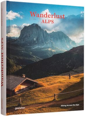
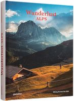
Reisinspiratieboek Wanderlust Alps | Gestalten Verlag

0
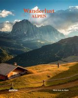
Stretching from France all the way down to Slovenia, the Alps are the highest and most expansive mountain range in Europe. For hikers, trekkers and outdoor enthusiasts alike, that means boundless possibilities for adventure. Wanderlust Alps charts the mountain range's best routes and hidden trails away from the crowds. The featured hikes offer a r...

Webshops met dit product

Webshop
Bezorging
Prijs
DeZwerver.nl logo
DeZwerver.nl
niet bekend
44,95

Anderen bekeken ook

Reisinspiratieboek Wanderlust British and Irish Isles | Gestalten Verlag
From breathtaking nature to timeless culture, explore the hiking trails and the wonders of the British Isles. The British and Irish Isles are a paradise for hikers. They provide a unique blend of breathtaking nature, fascinating local history, and timeless culture. Stunning photography showcases the diverse natural landscapes and rich national history of the region. The book offers maps, valuable insights on the trails, the best time to hike them, and regional specialties that will help readers make the most of their adventures. Whether you're an avid hiker or an armchair traveler, this new addition to the Wanderlust series will take you from the heart of the Scottish Highlands, to the Lake District, Ireland, and onward to the expansive coastline of the English Riviera. In addition to highlighting the natural and historical monuments of the islands, this book celebrates the best hiking trails and details the best of British and Irish culture, providing readers with some unique spots t…
55,95
Wandelgids Alpe-Adria Trail | Bradt Travel Guides
Goede wandelgids met heel veel praktische informatie. Naast een duidelijke beschrijving van de route veel adressen om te kunnen overnachten. Per etappe wordt er een hoogteprofiel gegeven, kaartmateriaal is iets minder van kwaliteit, per deel van de route wordt verwezen naar de echte wandelkaarten.  This is the first English-language guide to the epic new 750-km hiking route through the mountains of Austria, Slovenia and Italy, from the foot of the Grossglockner (at 3,798m, the highest peak in Austria and the Eastern Alps) to Muggia near Trieste on the Adriatic coast. Detailed maps and route descriptions for all 44 stages of the route are included, with a clear breakdown of time, distance and ascent for each stage. Published in a small, handy-sized format which is easy to pack and carry, it is written by an expert who has authored over half a dozen hiking guides and who specialises in Eastern and Central Europe. He has been a regular visitor to the borderlands of Slovenia, Austria and …
20,95
Reisinspiratieboek - Reisboek Book of the Alps | Marmota Maps
The Book of the Alps  the great illustrated book about the Alps.290 pages with over 1000 illustrations, graphics, and maps on geography, sports, history, culture, climate, environment and much more. Understand the Alps like never before.Created in cooperation with the Alpine clubs of Germany, Austria, and South Tyrol. CONTENTS The Book of the Alps has 46 chapters in seven subject areas: Geography   Flora and Fauna   Climate and Environment    Alpinism   Mountain Sports   Society and Economy   Arts and Culture   GEOGRAPHY Geological Formation Ice Age Mountains Valleys Mountain Passes Lakes and Rivers Glaciers The Alps are unique. How did they form and evolve? How do glaciers, passes, valleys, lakes, and rivers shape the landscape? Answers to these and many more questions can be found in the geography chapter.   FLORA AND FAUNA Biodiversity Plants Forests Animals National Parks The Alpine environment is fascinating. Alpine flowers such as the edelweiss and Alpine anima…
44,95
Reisinspiratieboek National Trails of America | Lonely Planet
Hike across some of America's most impressive and scenic trails with this inspiring travelling companion from Lonely Planet. With a foreword by celebrated author Cheryl Strayed, the celebrated author of Wild: A Journey From Lost To Found, the National Trails of America features the US's 30 National Trails - from the scenic wonder of the Pacific Crest Trail to the heavy history of the Trail of Tears - as well as 28 others. Hikers will discover the majesty of each route and all the unmissable stops along the way.   With a series of beautifully-shot photos and maps scattered throughout, this comprehensive guide to America's best trails can't help but inspire. From the epic scenery of the mighty Grand Canyon to the steamy rainforests of Puerto Rico, and from the historic battlefields of Eastern Tennessee to the Gateway Arch of St. Louis, no corner of America is left unturned. Plus, with accompanying planning details for each and every hike, including details on where to stay, top tips alo…
27,95
Reisinspiratieboek Wanderlust Himalaya | Gestalten Verlag
Wanderlust Himalaya explores one of the most appealing regions to hikers around the globe. First-hand tips, informative maps, and an array of spectacular photography for trails in Nepal, India, Pakistan, Tibet (China), and Bhutan provide orientation in an area that would allow lifetime wandering. Expect to be guided through breathtaking nature, diverse cultures, and hikes on different skill levels arranged in an attractive mix of one-day, multi-day, or long-distance trails. Our new release in the Wanderlust series lifts you to the top of the mountains.
47,50
Wandelgids Trekking the Tour Des Combins | Knife Edge Outdoor
The definitive guidebook for the Tour des Combins: the new bucket list trek in the Swiss/Italian Alps. A superb alternative to the more famous Tour du Mont Blanc. Two-way guide: both clockwise and anti-clockwise routes are described in full. Real Maps: full mapping inside (1:40,000), made specifically for Knife Edge Outdoor Guidebooks. All accommodation/campsites are numbered and marked on the maps. 10 different itineraries: schedules of 6, 7, 8 and 9 days for hikers and runners. Includes both clockwise and anti-clockwise itineraries. Difficult calculations of time, distance and altitude gain/loss are done for you. Also includes: * Detailed information on equipment and travelling light * Full accommodation/campsite listings * Wild camping rules explained * Everything the trekker needs to know: route, costs, difficulty, weather and more * Travel to the trail-head * Essential info for both self-guided and guided trekkers * Information on plants and wildlife * Numbered wayp…
27,50
Fietskaart 01 Cycling guides Cornwall | Goldeneye
Our maps are double-sided, printed on an A2 sheet with a concertina fold. This allows for easy folding and folding, and an ease of access to the mapping. The material is rain and tear-resistant. Our early maps were designed at the scale of 2 miles to 1 inch/1:126,720. The later designs along with digitalisation are 1: 100,000. We were encouraged by the Cycle Touring Club to convert our cartography toward the cycle market (to replace the out-of-print Bartholomew series). As time and the series progressed we have added more data: The National Cycle Network routes, Regional Routes, and Traffic-Free Family Routes, as and when they are developed. These routes are in addition to the Circular Routes Goldeneye Commissioned at the outset of our publishing schedule. We are also adding to new editions; bike shops, cycle hire, and tea rooms, along with the tourist attractions already featured. Our plan is to make available digital versions for cell phones and tablets and to update, on an annual b…
15,95
Wandelgids Wilderness Trekking Oman | Gilgamesh
The Hajar Mountains rise up from the great central deserts of the Arabian plateau - the so-called Empty Quarter - and then look down to the coastal plain that runs into the waters of the Gulf of Oman. Beautiful and remote, often almost entirely inaccessible, these harsh rocky slopes with their breathtaking views of Oman are largely unexplored. Wilderness Trekking in Oman is a practical guide for hiking in the Western Hajar, following some 200km of mountain trails. Meticulously researched and presented with detailed original cartography, this comprehensive guide is the key to discovering a remarkable landscape. The mountain traverse follows the spine of the mountains in a point-to-point walk taking 16 days which can be broken down into eight one-day walks, two two-day walks, and one four-day walk. There is a road intersection with a village or hotel between each of these 11 sections. The traverse climbs to the highest accessible peak in the country at 2999m and finishes in remote dry …
16,50
Wandelgids Via Dinarica | Bradt Travel Guides
Bijzondere wandelgids : het beschrijft de wandelroute in Bosnie Herzegovina van de Via Dinarica, the White trail. Veel praktische informatie, redelijk kaartmateriaal en een goede beschrijving van de route.  This is the first detailed guide to the Bosnian part of the new Via Dinarica hiking trail that carves its way through the Dinaric Alps, one of Europe's least explored mountain ranges and last true wilderness frontiers, connecting the seven nations of Slovenia, Croatia, Bosnia and Herzegovina, Montenegro, Serbia, Kosovo, and Albania. In total, this trail system will span over 1,350km, 333km of which is in Bosnia Herzegovina. The Via Dinarica consists of three routes - White, Green and Blue - and this guide focuses primarily on the White Trail through Bosnia and Herzegovina, following the natural flow of the highest peaks of the Dinaric Alps. Detailed descriptions of each of the 12 stages of the White Trail through Bosnia and Herzegovina are included, along with maps, altitude charts…
20,95
Reisgids Road Trips Electric Vehicle Road Trips - Europe | Lonely Planet
Hit the road with this ultimate guide to exploring Europe by electric car and discover 60 sublime touring routes with detailed itineraries, maps and charging station locations. Drive into the heights of the Austrian Alps or steer past thundering waterfalls in Iceland using our expert know-how to help you plan your next epic eco-friendly adventure. Cruise the north coast of Crete to find glorious golden beaches and hill-hugged fishing villages or weave your way across Ireland from the heart of Dublin to Galway, sampling the country's finest oysters as you go.   Whether you take your trusty electric vehicle for a spin or you hire a high-end model, this comprehensive guide is packed with irresistible road trips that are suitable for electric vehicles even with a modest range. All of the 60 unforgettable touring routes will guide you to a convenient charging station at the end of each day, allowing you to discover the continent in sustainable style. Inside Electric Vehicle Road Trips - Eu…
34,95

Klanten-reviews van Reisinspiratieboek Wanderlust Alps | Gestalten Verlag

Er zijn nog geen beoordelingen voor dit productBen jij de eerste die een review plaatst?

Meer over Reisinspiratieboek Wanderlust Alps | Gestalten Verlag

Productomschrijving

Stretching from France all the way down to Slovenia, the Alps are the highest and most expansive mountain range in Europe. For hikers, trekkers and outdoor enthusiasts alike, that means boundless possibilities for adventure. Wanderlust Alps charts the mountain range's best routes and hidden trails away from the crowds. The featured hikes offer a rich mix of single-day jaunts to long-distance treks for hikers of all experience levels, with plenty of stunning nature and charming mountain huts to enjoy along the way.

Verken gerelateerde categorieën

Webshop.nl maakt gebruik van cookies. Ga je verder op onze website, ga dan akkoord met het plaatsen van cookies en de verwerking van deze data door ons en vermelde partners.