webshop.nl
Categorieën
  Sluiten

Meer Moon Travel Guides

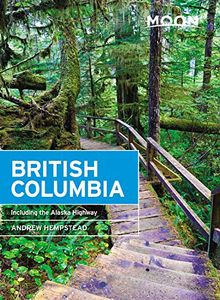
Reisgids British Columbia | Moon Travel Guides

Uitstekende Amerikaanse reisgids van uitgever Moon. De gids is vergelijkbaar met Lonely Planet en Rough guide en is voor de backpacker - zelfstandige reiziger geschreven; toch is deze door de grote mate van details en achtergronden geschikt voor alle reizigers! De gids onderscheidt zich door gedegen en uitgebreide achtergrondinformatie over bijvoor...
23,95

Webshops met dit product

Webshop
Bezorging
Prijs

Anderen bekeken ook

Reisgids British Columbia | Moon Travel Guides
Uitstekende Amerikaanse reisgids van uitgever Moon. De gids is vergelijkbaar met Lonely Planet en Rough guide en is voor de backpacker - zelfstandige reiziger geschreven; toch is deze door de grote mate van details en achtergronden geschikt voor alle reizigers! De gids onderscheidt zich door gedegen en uitgebreide achtergrondinformatie over bijvoorbeeld natuur en cultuur. British Columbia is filled with vibrant cities, secluded beaches, and old-growth rainforests. Experience the best of this wild and beautiful province with Moon British Columbia. Inside you'll find: Flexible itineraries, from one week in Vancouver and Victoria to a two-week tour of the entire province Strategic advice for outdoor adventurers, foodies and wine lovers, families, and more Must-see highlights and unique experiences: Try to spot wild bears, moose, and elk, go whale-watching on the Pacific, or snorkel with seals. Learn about the First Nations tribes' colorful totem poles and sample indigenous foods, or sip y…
23,95
Wegenkaart - landkaart Southern Alberta & Southern British Columbia |
ITMB, being based in Vancouver, BC, understandably has a local/regional market for our map line. We have a map of Western Canada, as well as an atlas, a very nice map of BC itself, a map of the south half of BC, and a map of part of BC combined with Washington State. What we did not have, until now, was a map covering the most touristically-visited part of all of Canada – namely, the southern halves of both British Columbia and its neighbour, Alberta, with a small amount of Washington State, Idaho, and Montana (to assist those heading north and needing to know about border crossings). Therefore, ITMB is pleased to announce the release of Southern BC and Alberta. Side One covers BC from the US border (with a carry-on to Seattle) north to Prince George and east to the Alberta border, with a carry-on to Calgary. All of Vancouver Island, the Okanagan Valley, and the Rock Mountain National Parks of Banff and Jasper, are included. The map is rich with wilderness campsite (almost 1,000 are sh…
13,95
Reisgids Road Trip USA Vancouver and Canadian Rockies | Moon Travel Gu
From the ocean to the mountains, go off the beaten path and into the heart of Western Canada with Moon Vancouver & Canadian Rockies Road Trip. Flexible itineraries: Drive the entire two-week road trip or follow strategic routes, like a week-long drive along the coast of British Columbia, with suggestions for shorter getaways to Victoria, Vancouver, Banff, Lake Louise, Jasper, and the Okanagan Eat, sleep, stop and explore: With lists of the best trails, views, and more, you can hike the Rocky Mountains, canoe in Lake Louise, and snorkel with seals in the Pacific. Explore one of Vancouver's many parks, soak up the surfer vibe in Tofino, or go wine-tasting in the Okanagan Maps and driving tools: 49 easy-to-use maps keep you oriented on and off the highway, along with site-to-site mileage, driving times, detailed directions for the entire route, and full-color photos throughout Local expertise: Seasoned road-tripper and Vancouver local Carolyn B. Heller shares her passion for the mount…
23,95
Wegenkaart - landkaart Southern Alberta & Southern British Columbia |
ITMB, being based in Vancouver, BC, understandably has a local/regional market for our map line. We have a map of Western Canada, as well as an atlas, a very nice map of BC itself, a map of the south half of BC, and a map of part of BC combined with Washington State. What we did not have, until now, was a map covering the most touristically-visited part of all of Canada – namely, the southern halves of both British Columbia and its neighbour, Alberta, with a small amount of Washington State, Idaho, and Montana (to assist those heading north and needing to know about border crossings). Therefore, ITMB is pleased to announce the release of Southern BC and Alberta. Side One covers BC from the US border (with a carry-on to Seattle) north to Prince George and east to the Alberta border, with a carry-on to Calgary. All of Vancouver Island, the Okanagan Valley, and the Rock Mountain National Parks of Banff and Jasper, are included. The map is rich with wilderness campsite (almost 1,000 are sh…
13,95
Wegenkaart - landkaart Northern British Columbia | ITMB
British Columbia is big! Gargantuan huge, in fact, although it is lightly populated. ITMB published a map of the more densely populated southern half of the province a number of years ago, and we have been asked to give the same emphasis to the northern half ever since. Here it is! Side 1 is of the western portion, including the Alaskan Panhandle, with the route followed by cruise ships heading north and clearly delineates the border between Canada and the USA that nearly erupted into warfare (54 40 or fight). It also shows the Stewart Highway heading north towards the Yukon, with its branch leading to Hyder, Alaska, the only place in the USA that uses Canadian money and does all its banking in Canada. The second side covers the eastern half of BC’s north, with the Alaska Highway starting in Dawson Creek and extending north to Fort Nelson before veering west into the eastern edge of the Rocky Mountains to the Yukon border. This is true wilderness country. It is virtually unpopulated ou…
14,95
Wegenkaart - landkaart 04 Southwest British Columbia & Northern Washin
Goede wegenkaart van British Columbia met Nationale Parken, Overnachtingsmogelijkheden, Ski gebieden en bezienswaardigheden. Gem Trek’s Southwest British Columbia & Northern Washington map meets the needs of visitors looking to explore the lower mainland of British Columbia and the northern section of Washington state.   All the major highways are shown, as well as national, provincial, and state parks and wilderness areas. The map also shows lesser-known back roads, and pinpoints the location of lodges, campgrounds and hot springs. Mileage charts on the front and back provide distances between major towns and cities.   The Southwest British Columbia & Northern Washington map covers all of Vancouver Island and extends west through the city of Vancouver and the Okanagan Valley to the Kootenays. South of the border, Washington state is covered from the Gulf Islands in the west to Spokane in the east, with coverage as far south as Mount Rainer National Park.   The Southwest British Colum…
8,95
Reisgids British Columbia & the Canadian Rockies - Canada | Lonely Pla
De perfecte reisgids over British Columbia voor zowel de georganiseerde als de zelfstandige reiziger. Naast een algemene inleiding van het land / streek vol met praktische informatie over hoe je er het beste kunt reizen: slapen, eten, vervoer, excursies ... alles kun je er in vinden. Engelstalig. Lonely Planet's local travel experts reveal all you need to know to plan the trip of a lifetime to British Columbia & the Canadian Rockies.   Discover popular and off the beaten track experiences from searching for the world's rarest bear in the Great Bear Rainforest to sampling global street foods at the Richmond Night Market, and taking an authentic, indigenous-led fishing excursion in Haida Gwaii.   Build a trip to remember with Lonely Planet's British Columbia & the Canadian Rockies travel guide:   Our classic guidebook format provides you with the most comprehensive level of information for planning multi-week trips Updated with an all new structure and design so you can navigate …
24,95

Klanten-reviews van Reisgids British Columbia | Moon Travel Guides

Er zijn nog geen beoordelingen voor dit productBen jij de eerste die een review plaatst?

Meer over Reisgids British Columbia | Moon Travel Guides

Productomschrijving

Uitstekende Amerikaanse reisgids van uitgever Moon. De gids is vergelijkbaar met Lonely Planet en Rough guide en is voor de backpacker - zelfstandige reiziger geschreven; toch is deze door de grote mate van details en achtergronden geschikt voor alle reizigers! De gids onderscheidt zich door gedegen en uitgebreide achtergrondinformatie over bijvoorbeeld natuur en cultuur. British Columbia is filled with vibrant cities, secluded beaches, and old-growth rainforests. Experience the best of this wild and beautiful province with Moon British Columbia. Inside you'll find: Flexible itineraries, from one week in Vancouver and Victoria to a two-week tour of the entire province Strategic advice for outdoor adventurers, foodies and wine lovers, families, and more Must-see highlights and unique experiences: Try to spot wild bears, moose, and elk, go whale-watching on the Pacific, or snorkel with seals. Learn about the First Nations tribes' colorful totem poles and sample indigenous foods, or sip your way through the wines of the lush Okanagan Valley. Kayak through icy fjords, ski Whistler's world-class slopes, or drive the famed Alaska Highway Reliable tips from BC local Andrew Hempstead on where to eat, where to stay, and how to get around Full-color photos and detailed maps throughout Background information on the landscape, culture, history, and environment In-depth coverage of Vancouver, Victoria and Vancouver Island, the Sunshine Coast, Sea to Sky Highway, Whistler, Gold Nugget Route, the Okanagan Valley, the Kootenays, the Canadian Rockies, Glacier National Park, Revelstoke, Kamloops, Mount Robson, Cariboo Country, Prince George, Prince Rupert, Haida Gwaii, Stewart-Cassar Highway, Alaska Highway, and the Yukon

Productspecificaties

Artikelnummer(s)
Brand
Moon Travel Guides
Webshop.nl maakt gebruik van cookies. Ga je verder op onze website, ga dan akkoord met het plaatsen van cookies en de verwerking van deze data door ons en vermelde partners.