Niemandsland (Hardback)

0
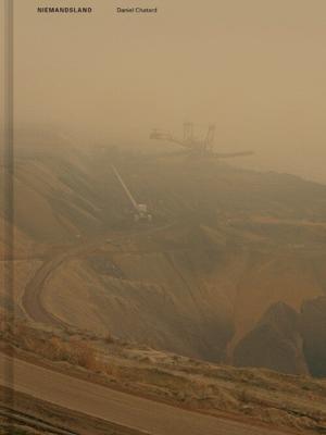
'Niemandsland' investigates the impact of brown coal extraction in Germany's Rhineland, where some of Europe's largest open-cast lignite mines have dramatically altered the landscape and contributed heavily to CO2 emissions. These mines have displaced entire villages, causing a sense of powerlessness among residents who grew up knowing that their h...

Verkopers met dit product

Verkoper
Bezorging
Prijs

Anderen bekeken ook

Fietskaart 01 Cycling guides Cornwall | Goldeneye
Our maps are double-sided, printed on an A2 sheet with a concertina fold. This allows for easy folding and folding, and an ease of access to the mapping. The material is rain and tear-resistant. Our early maps were designed at the scale of 2 miles to 1 inch/1:126,720. The later designs along with digitalisation are 1: 100,000. We were encouraged by the Cycle Touring Club to convert our cartography toward the cycle market (to replace the out-of-print Bartholomew series). As time and the series progressed we have added more data: The National Cycle Network routes, Regional Routes, and Traffic-Free Family Routes, as and when they are developed. These routes are in addition to the Circular Routes Goldeneye Commissioned at the outset of our publishing schedule. We are also adding to new editions; bike shops, cycle hire, and tea rooms, along with the tourist attractions already featured. Our plan is to make available digital versions for cell phones and tablets and to update, on an annual b…
15,95
Reisgids Marco Polo DE Pfalz | MairDumont
Handige en overzichtelijke, kleine reisgids voor een eerste kennismaking met de vakantiebestemming. Globale uitklapkaart achterin, makkelijk binnenzakformaat. Vaak voldoende voor een paar dagen! DUITS Burgen, Reben und Legenden:Entdecke mit dem MARCO POLO Reiseführer die Pfalz Von Mittelalter- bis Industrieromantik, von Weingenuss bis Waldabenteuer: Der Süden von Rheinland-Pfalz hält viele Highlights bereit! Über die Jahre haben römische, französische und bayerische Einflüsse die Pfalz geprägt.   Hier können sich Outdoor-Fans beim Wandern, Mountainbike fahren oder Klettern auspowern. Wenn du es gemütlicher angehen willst, radelst du ganz entspannt auf Rheinpromenaden und probierst bei einem der zahlreichen Weinfeste einen edlen Tropfen. In Mannheim schnupperst du bei der Hafenrundfahrt Industrieluft und auf dem Hambacher Schloss erfährst du alles über die Wiege der deutschen Demokratie.   Wonach dir auch der Sinn steht: Mit den Tipps aus deinem MARCO POLO Reiseführer Pfalz stellst du …
18,50
Fietskaart 09 Cycling guides Norfolk | Goldeneye
Norfolk is the fourth largest county in England and one of the most rural. It is also one of the flattest and our circular routes have been chosen to explore the quiet lanes linking the isolated and picturesque villages and places of interest. This is ideal cycling territory and fortunately, the Norfolk County Council (and its District Councils) are seriously committed in providing and developing cycling routes and in promoting a cycling culture that is sustainable and family friendly. Some of their routes are illustrated, hitherto.   The County has been described as flat (rather gentle undulations) and does not in fact rise much over 300 feet, but it offers great scenic interest; the dark forests of Breckland, the rolling chalk lands of the northwest, the unique watery patch of the Broads, and a coastline of great variety. Ancient churches and picturesque villages are there in abundance, the latter often decorated with the attractive signs designed by Harry Carter in the 1950’s.   Re…
14,95
Fietskaart 10 Cycling guides North York Moors | Goldeneye
Scheur- en watervast foetskaart van de North York Moors  met ingetekende fietsroutes.   Our maps are double-sided, printed on an A2 sheet with a concertina fold. This allows for easy folding and folding, and an ease of access to the mapping. The material is rain and tear-resistant. Our early maps were designed at the scale of 2 miles to 1 inch/1:126,720. The later designs along with digitalisation are 1: 100,000. We were encouraged by the Cycle Touring Club to convert our cartography toward the cycle market (to replace the out-of-print Bartholomew series). As time and the series progressed we have added more data: The National Cycle Network routes, Regional Routes, and Traffic-Free Family Routes, as and when they are developed. These routes are in addition to the Circular Routes Goldeneye Commissioned at the outset of our publishing schedule. We are also adding to new editions; bike shops, cycle hire, and tea rooms, along with the tourist attractions already featured. Our plan is to m…
14,95
Wandelgids Walking in the Thames Valley | Cicerone
Walking in the Thames Valley offers 25 challenging circular walks around the River Thames and River Kennet in the south of England, taking in the Southern Chilterns, the Berkshire and North Hampshire Downs, Southern Oxfordshire and the eastern edge of Wiltshire. All routes are within easy reach of Reading, Newbury, Abingdon and London. While some walks visit Iron Age hill forts, others pass more modern features such as Wilton Windmill and the Kennet and Avon Canal. Some follow sections of the Ridgeway, while others meander along the banks of the Thames. What they all have in common is that they take the keen rambler to some of the best parts of the Thames Valley – a patchwork of open chalk grassland, broadleaved woodland and farmland and home to two Areas of Outstanding Natural Beauty. • walks from 10 to 18 miles, including one 2-day route • shorter, less strenuous alternatives for many of the walks • detailed route descriptions with information on local points of interest, OS mapping…
18,50
Wandelgids Walk! La Gomera | Discovery Walking Guides
La Gomera is the ultimate get-away-from-it-all island: easy-going, unspoilt, friendly, isolated from the hustle and bustle of modern living, and so laid back it’s virtually supine - even the volcanoes have been dormant for millions of years. The walks, however, are a bit more energetic. For the new 4th edition of Walk! La Gomera Charles Davis has teamed up with Jan Kostura. Jan brings his wide experience and passion for the Canaries, checking, re-walking and revising existing routes, and adding a couple of his own adventures, including a new Top Three Gomeran walk. Two routes have been dropped as having become too dangerous, but the good news is that many of the more harum-scarum walks have been improved through path clearing and the addition of railings to the vertiginous stretches. Other good news is that the devastating forest fires of 2012 have proved not nearly as damaging as we feared, leaving most of our itineraries unscathed. In short, there is every reason to take off and ex…
17,50
Fietskaart Cycling guides Dartmoor - South Devon | Goldeneye
Dartmoor. One of England’s greater National Parks; the Forest of Dartmoor covers 365 square miles and contains the highest ground in England south of the Peak District. On its desolate moorland tracks the wanderer can believe they are further from a public road than anywhere in the country, but on the fringes lush valleys lead down on every side to thick woodland, green vegetation and picturesque villages. Dartmoor is well known for its wildlife - attractive herds of ponies, seemingly wild but in fact individually owned, foxes, badgers and otters - also the occasional adder. Fallow, roe and Sitka deer can often be seen, but the red deer of Exmoor have never penetrated the area. Buzzards, kestrels and various Birds of Prey are frequently seen, as well as the wheatear, while crows, ravens and the skylark are fairly commonplace. The Moor abounds in prehistoric remains. There are also many deserted medieval villages with remains of the traditional ‘longhouse’ buildings. For centuries tin …
12,95
Reisverhaal Wild Abandon - Dodecanesos | Jennifer Barclay
'There's something about abandoned places which moves me and captures the imagination.' So says seasoned travel writer Jennifer Barclay as she walks with her dog and her backpack through the deserted spaces of the Dodecanese, islands that were once bustling but are now half forgotten and reclaimed by the wild due to a mix of misfortune and the lure of opportunity elsewhere. Join her on a journey through abandoned villages and farms, cave-houses and captains' mansions, the homes of displaced Muslim fishermen and poets, as she discovers beauty in the ruins, emptiness and silence, and inspiration in the stories of people's lives.A long-term resident of Greece, Jennifer Barclay spent more than four years researching Wild Abandon, visiting islands multiple times and hearing the stories of local people. She travels from the very west to the very east of the Dodecanese, from the very south almost to the very north, taking in some of the smallest and the biggest islands, and highlighting diff…
14,95
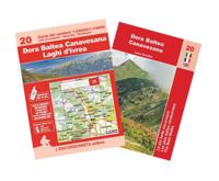
Wandelkaart 20 Dora Baltea Canavesana - Laghi d'Ivrea | L'Escursionista editore
Voor weinig gebieden in Italië zijn echt goede wandelkaarten beschikbaar. Dit is gelukkig zo'n serie: voor de noordwestelijke Alpen van Italië, Gran Paradiso, Mont Blanc en Aosta en omgeving.   Met GPS grid uitgeruste detailkaart, schaal 1:25.000 met alle noodzakelijke wandelinformatie als ingetekende routes, Via Ferrata routes, campings, berghutten en schuilhutten, dat alles met een kaart die veel topografische details kent.    Hoogtelijnen van 25 m. interval, schaduwtekeningen en goed gebruik van kleur voor bijvoorbeeld gletsjers en bossen. Naast ingetekende routes zijn er ook gewone voetpaden op te vinden.    Bijgeleverd wordt (niet bij elke kaart) een kleine brochure met wandelmogelijkheden in dat bepaalde gebied.   Only recently has the Dora Baltea Canavese district been discovered by tourists, foreigners for the most part. It has unique landscapes of great interest for visitors. Located at the opening of the Aosta valley, it is geographically distinct. Running along its side an…
15,95
Fietskaart 14 Cycling guides Suffolk | Goldeneye
To be confronted with the variety and complexity of the cycling routes, trails and paths in Suffolk can be a bewildering experience.  For it appears that the Suffolk County Council and the three District Councils are all trying hard to promote their areas. This is indeed encouraging for the growth of cycling, but it can be confusing.  Our purpose is to provide clear, easy to use and easy to follow, cycling maps, and to illustrate these in a comprehensive form.    Suffolk must be one of the most charming of counties to explore by bicycle. When Al Churcher delivered his routes to us at Goldeneye we couldn’t keep him quiet, such was his enthusiasm and wonder at Suffolk’s country lanes and byways. He has cycled all over the UK, Canada, Mallorca, New Zealand and Sicily, but Suffolk remained a firm favourite.    The inland scenery is not spectacular for the county’s main glory lies with its attractive villages; the local architecture jealously preserved from modern depredation. There is an …
15,95

Klanten-reviews van Niemandsland (Hardback)

Er zijn nog geen beoordelingen voor dit productBen jij de eerste die een review plaatst?

Meer over Niemandsland (Hardback)

Productomschrijving

'Niemandsland' investigates the impact of brown coal extraction in Germany's Rhineland, where some of Europe's largest open-cast lignite mines have dramatically altered the landscape and contributed heavily to CO2 emissions. These mines have displaced entire villages, causing a sense of powerlessness among residents who grew up knowing that their homes would one day be destroyed. In 2012, environmental activists occupied Hambach Forest. Despite some success in preserving parts of the forest and five villages, a sixth village, Lützerath, was demolished. By engaging with the affected communities, Daniel Chatard (DE) shows the emotional and physical toll of the mining operations. A reminder of the costs of energy production and the enduring human spirit in the face of overwhelming odds.

Productinformatie

    Verken gerelateerde categorieën

    Webshop.nl maakt gebruik van cookies. Ga je verder op onze website, ga dan akkoord met het plaatsen van cookies en de verwerking van deze data door ons en vermelde partners.