Meer National Geographic
Meer National Geographic in Portofoons

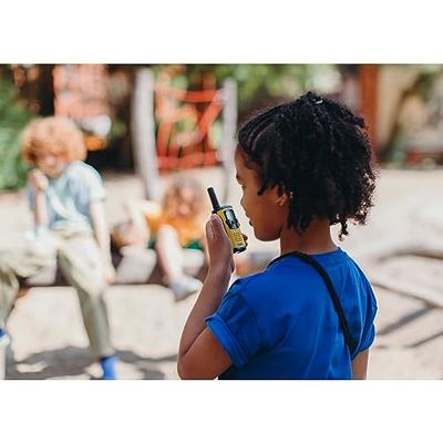
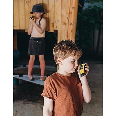
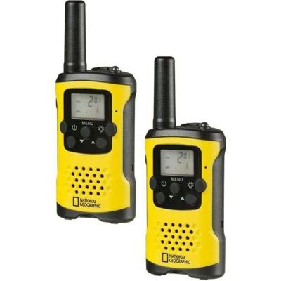
NATIONAL GEOGRAPHIC walkietalkies met groot bereik tot 6 km en handsfreefunctie

0
Copy that, Roger! Featuring a hands-free function and a built-in torch, these walkie-talkies allow you to stay in contact during outdoor adventures at distances of up to 6 km....

Verkopers met dit product

Verkoper
Bezorging
Prijs
Folux.nl logo
Folux.nl
1-2 dagen
5,95
42,09

Anderen bekeken ook

-30%
Prestara Walkie Talkies voor Kinderen en Volwassenen met USB-oplaadkabel en 2 Oplaadbare Accu's - Veiligheid en Plezier voor Elk Avontuur!
Op zoek naar de perfecte Prestara Walkie Talkies voor zowel kinderen als volwassenen? Met deze Walkie Talkies van Prestara kun je moeiteloos communiceren tijdens avonturen zoals wandelen, fietsen, kamperen, of spelen. Ze bieden niet alleen plezier, maar ook extra veiligheid dankzij constante communicatie. Dankzij de meegeleverde USB-oplaadkabel en 2 oplaadbare accu's kun je de Walkie Talkies eenvoudig opladen en langdurig gebruiken, zonder dat je telkens nieuwe batterijen hoeft aan te schaffen.Met functies zoals een ingebouwde zaklamp, 22 kanalen en een helder LCD-scherm zijn deze Prestara Walkie Talkies ideaal voor binnen- en buitenactiviteiten. Kinderen kunnen hun communicatieve vaardigheden ontwikkelen terwijl jij altijd weet waar ze zich bevinden.Waarom Kiezen voor Prestara Walkie Talkies met Oplaadbare Accu's?Veiligheid Voorop: Zorg voor een veilige speelomgeving door altijd in contact te blijven, of ze nu in de buurt zijn of op avontuur.Lange Batterijduur met Oplaadbare Accu's: D…

49,95

34,95
-30%
Prestara Walkie Talkies voor Kinderen en Volwassenen met USB-oplaadkabel en 2 Oplaadbare Accu's - Veiligheid en Plezier voor Elk Avontuur | Roze
Op zoek naar de ideale Prestara Walkie Talkies in een stijlvolle roze kleur voor zowel kinderen als volwassenen? Deze Walkie Talkies van Prestara bieden je de mogelijkheid om moeiteloos te communiceren tijdens avonturen zoals wandelen, fietsen, kamperen of spelen. Ze brengen niet alleen plezier, maar ook veiligheid dankzij constante communicatie. Met de meegeleverde USB-oplaadkabel en 2 oplaadbare accu's kun je de Walkie Talkies gemakkelijk opladen en langdurig gebruiken zonder steeds nieuwe batterijen nodig te hebben.Dankzij functies zoals een ingebouwde zaklamp, 22 kanalen en een helder LCD-scherm zijn deze roze Prestara Walkie Talkies ideaal voor zowel binnen- als buitenactiviteiten. Kinderen ontwikkelen hun communicatieve vaardigheden en jij blijft altijd in contact, waar ze zich ook bevinden.Waarom Kiezen voor Prestara Walkie Talkies met Oplaadbare Accu's?Veiligheid Voorop: Bied een veilige speelomgeving door eenvoudig contact te houden, of ze nu dichtbij zijn of op avontuur.Lange…

49,95

34,95
Wegenkaart - landkaart 3308 Adventure Map Pyrenees & Andorra - Pyreneeën en Andorra | National Geographic
Wegenkaart van de Pyreneeën en Andorra met vermelding van veel bezienswaardigheden, nationale parken en attrakties. Watervast en scheurvast. Juist door deze vermeldingen onderscheidt de kaart zich van andere wegenkaarten. National Geographic's Pyrenees and Andorra Adventure Map is designed to meet the unique needs of adventure travelers—detailed, durable, and accurate. Pyrenees/Andorra includes the locations of thousands of major cities and towns with an index for easily locating them, plus a clearly marked road network complete with distances and designations for expressways, motorways, scenic routes, and more.   What sets National Geographic AdventureMaps apart from traditional road maps are the hundreds of points of interest that highlight the diverse and unique destinations within the Pyrenees and Andorra. National parks, World Heritage sites, scenic viewpoints, antiquity sites, museums, places of worship, zoos, castles and more are included, making it invaluable to travelers hopi…
17,50
Wegenkaart - landkaart 3307 Adventure Map Spain & Portugal - Spanje en Portugal | National Geographic
Wegenkaart van Spanje en Portugal met vermelding van veel bezienswaardigheden, nationale parken en attracties. Watervast en scheurvast. Juist door deze vermeldingen onderscheidt de kaart zich van andere wegenkaarten.   National Geographic's Spain and Portugal Adventure Map is designed to meet the unique needs of adventure travelers—detailed, durable, and accurate. Spain/Portugal includes the locations of thousands of major cities and towns with an index for easily locating them, plus a clearly marked road network complete with distances and designations for expressways, motorways, and more.   What sets National Geographic Adventure Maps apart from traditional road maps are the hundreds of points of interest that highlight the diverse and unique destinations within Spain/Portugal. National parks, World Heritage sites, caves, scenic viewpoints, archeological sites, museums, castles, churches, monasteries, and ruins are included, making it invaluable to travelers hoping to experience all…
17,50
Nieuw
Wegenkaart - landkaart 3300 Adventure Map Finland & Northern Scandinavia - Finland en noord Scandinavië | National Geographic
Wegenkaart van Finland en noord Scandinavië met vermelding van veel bezienswaardigheden, nationale parken en attrakties. Watervast en scheurvast. Juist door deze vermeldingen onderscheidt de kaart zich van andere wegenkaarten. National Geographic's Finland and Northern Scandinavia Adventure Map is designed to meet the unique needs of adventure travelers with its detail, durability, and accuracy. Scandinavia North includes the locations of thousands of cities and towns with an index for easily locating them, plus a clearly marked road network complete with distances and designations for expressways, motorways, and more. What sets National Geographic Adventure Maps apart from traditional road maps are the hundreds of points of interest that highlight the diverse and unique destinations within northern Scandinavia. World Heritage sites, museums, amusement parks, zoos, castles, archeological sites, churches, and more are included, making it invaluable to travelers hoping to experience all…
17,50
Wegenkaart - landkaart 3301 Adventure Map Southern Sweden & Norway | Zuid Zweden en Noorwegen | National Geographic
Wegenkaart van Zuid Zweden en Noorewegen met vermelding van veel bezienswaardigheden, nationale parken en attrakties. Watervast en scheurvast. Juist door deze vermeldingen onderscheidt de kaart zich van andere wegenkaarten. National Geographic's Southern Sweden and Norway Adventure Map is designed to meet the unique needs of adventure travelers—detailed, durable, and accurate. Southern Sweden and Norway includes the locations of thousands of cities and towns with an index for easily locating them, plus a clearly marked road network complete with distances and designations for expressways, motorways, and more. Transportation within and beyond the country is made easier with the locations of airports, airfields, railroads, ferry routes, lighthouses, harbors, and international border checkpoints. What sets National Geographic Adventure Maps apart from traditional road maps are the hundreds of points of interest that highlight the diverse and unique destinations within Southern Sweden and…
17,50
Magneetbord - Wandkaart British Isles - Groot Brittannië en Ierland, 61 x 76 cm | National Geographic
Magneetbord van een wandkaart van Groot Brittannië en Ierland: prachtig kaartbeeld met heel veel details, gemaakt door de gerenommeerde makers van National Geographic. British Isles at 1:1,687,000 on a small wall map, 61 x 76cm (1’11” x 2’5” approx) , from the National Geographic Society showing the constituent parts of the United Kingdom, Irish Republic, Isle of Man and the Channel Islands. Shetland Islands are shown on an inset. The map uses NGS’s classic presentation style of white background plus relief shading to show the topography, with boundaries shown in colour. Within Great Britain, national parks are prominently highlighted. Names of many geographical regions are shown (The Wolds, South Downs, etc.); county boundaries are marked, but county names are indicated only by numbers cross-referenced to lists of counties and unitary authorities in England, with corresponding lists for Scotland, Wales, Northern Ireland and the Irish Republic. Latitude and longitude lines are drawn a…
189,-

Klanten-reviews van NATIONAL GEOGRAPHIC walkietalkies met groot bereik tot 6 km en handsfreefunctie

Er zijn nog geen beoordelingen voor dit productBen jij de eerste die een review plaatst?

Meer over NATIONAL GEOGRAPHIC walkietalkies met groot bereik tot 6 km en handsfreefunctie

Productomschrijving

Copy that, Roger! Featuring a hands-free function and a built-in torch, these walkie-talkies allow you to stay in contact during outdoor adventures at distances of up to 6 km.

Productinformatie

    Productspecificaties

    Artikelnummer(s)
    EAN
    4007922076201
    Brand
    National Geographic

    Verken gerelateerde categorieën

    Webshop.nl maakt gebruik van cookies. Ga je verder op onze website, ga dan akkoord met het plaatsen van cookies en de verwerking van deze data door ons en vermelde partners.