Kinderpuzzel GeoPuzzle Asia - Azië | GEOtoys

0
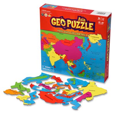
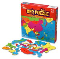
Unieke, educatieve puzzel van Azië met 50 puzzelstukjes in landvormen.  Gemaakt van gerecycled materiaal en ontwikkeld voor kinderen vanaf 4 jaar.   GeoPuzzles are maps of the major continents, with pieces shaped like individual countries. By putting together a GeoPuzzle, children learn what countries look like, what their names are, and where the...

Verkopers met dit product

Webshop
Bezorging
Prijs
DeZwerver.nl logo
DeZwerver.nl
niet bekend
18,95

Anderen bekeken ook

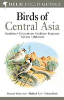
Vogelgids Centraal Azie - Birds of Central Asia | Bloomsbury
Birds of Central Asia is the first field guide to include the former Soviet republics of Kazakhstan, Kyrgyzstan, Turkmenistan, Uzbekistan and Tajikistan, along with neighbouring Afghanistan. This vast area includes a diverse variety of habitats, and the avifauna is similarly broad, from sandgrouse, ground jays and larks on the vast steppe and semi-desert to a broad range of raptors, and from woodland species such as warblers and nuthatches to a suite of montane species, such as snowcocks, accentors and snowfinches. Birds of Central Asia includes 141 high-quality plates covering every species (and all distinctive races) that occur in the region, along with concise text focusing on identification and accurate colour maps. Important introductory sections introduce the land and its birds. Birds of Central Asia is a must-read for any birder or traveller visting this remote region.   "For a long time, there's been something of a gap in field-guide coverage across the Palearctic. Europe is w…
50,95
Kinderpuzzel GeoPuzzle Africa and the Middle East - Afrika en het Midden Oosten | GEOtoys
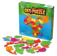
Unieke, educatieve puzzel van Afrika en het Midden Oosten met 65 puzzelstukjes in landvormen.  Gemaakt van gerecycled materiaal en ontwikkeld voor kinderen vanaf 4 jaar.   GeoPuzzles are maps of the major continents, with pieces shaped like individual countries. By putting together a GeoPuzzle, children learn what countries look like, what their names are, and where they are in relation to one another. At 50-70 pieces, the puzzles are perfect for ages 4-12. Designed by an art professor, GeoPuzzles are generously sized, brightly colored, and each piece is large enough to be easily handled.   GeoPuzzle Africa has 65 pieces, and is a jumbo-sized 17 x 17 inches.
18,95
Wandkaart - Magneetbord Azië Politiek - Asia Political, 120 x 100 cm | Maps International
Fraaie politieke kaart van het continent, waarbij vooral de politieke aspecten heel duidelijk te lezen zijn. Alle landen hebben verschillende kleuren, steden en belangrijke verbindingen zijn goed te vinden.   De kaart wordt in deze versie gelijmd op een plaat, voorzien van een mooie aluminium lijst en een ophangsysteem wordt meegeleverd. Daarnaast krijgt u een bakje bijgeleverd dat u er aan kunt bevestigen voor pennen, stiften of magneetjes.   Maps International's political wall map of Asia shows all countries from Turkey in the West to Japan in the East, down to Indonesia in the South of Asia. The largest and most populated continent, Asia has a lot to fit onto a map! Rest assured though, with Maps International's high quality of mapping nothing is missed out!   This political wall map of Asia features countries marked in different colours, with international borders clearly shown. The map's key shows the flags from the countries displayed in this map. This Asia physical wall map als…
269,-
Wandkaart - Prikbord Azië Politiek - Asia Political, 120 x 100 cm | Maps International
Fraaie politieke kaart van het continent, waarbij vooral de politieke aspecten heel duidelijk te lezen zijn. Alle landen hebben verschillende kleuren, steden en belangrijke verbindingen zijn goed te vinden.   De wandkaarten op prikbord worden geleverd met een aluminium lijst en een eenvoudig te monteren ophangsysteem. Zij zijn geschikt voor allerhande markeringsystemen als vlaggetjes en prikkers.   Maps International's political wall map of Asia shows all countries from Turkey in the West to Japan in the East, down to Indonesia in the South of Asia. The largest and most populated continent, Asia has a lot to fit onto a map! Rest assured though, with Maps International's high quality of mapping nothing is missed out!   This political wall map of Asia features countries marked in different colours, with international borders clearly shown. The map's key shows the flags from the countries displayed in this map. This Asia physical wall map also contains city population detail, capital cit…
185,-
Wegenkaart - landkaart Asia - Azië | National Geographic
• Waterproof • Tear-Resistant • Reference Map   Expertly researched and designed, National Geographic's Asia Flags & Facts Map is the authoritative map of Asia by which other reference maps are measured. The map side includeds a political map showing countries, cities and other landmarks and a physical map shows the landforms such as mountain ranges and rivers.   Clearly defined boundaries, major cities, and physical features Hundreds of place names carefully placed to maintain legibility in heavily populated areas Includes Asia including Russia and adjacent regions within Europe and Africa Detailed physical map of Asia with mountain ranges, plains, lakes, and rivers Flags and facts with detailed information about cultural and physcial attributes Printed in the U.S.A. on extremely durable, waterproof, and tear-resistant material This Reference Map is printed on durable synthetic paper, making it waterproof, tear-resistant and tough — capable of withstanding the rigors of any kind of u…
17,50
Reisverhaal Dreaming of Jupiter | Ted Simon
Ted Simon is the author of the classic travel book JUPITER'S TRAVELS. It documents his four-year journey round the world by motorbike, travelling through Europe, Africa, South and North America, and Asia. A number one bestseller in the late 1970s, it is still regarded as one of the greatest motorcycle books - indeed, one of the greatest travel books - ever written. In 2001, at the age of 69, Ted Simon decided to retrace his journey, and DREAMING OF JUPITER is the result. It took him two and a half years - during which time he revisited all the countries he had travelled through in the 1970s. He found much had changed, and he reflects upon the increased poverty, political upheavals, environmental issues and indeed the changes in himself. But ultimately, DREAMING OF JUPITER is a hugely inspiring read with a positive message at its heart - that even at the age of 70 you can still set off on an adventure, and be surprised and excited by what life throws at you along the way. *'Gloriously …
14,50
Reisgids Global Beer Tour | Lonely Planet
Leuke thematische reisgids waarin je de beste brouwerijen van de wereld vindt.   Explore the vibrant world of craft beer with Lonely Planet’s ale experts. We’ve selected the finest tap rooms, bars and breweries that thirsty travellers can visit in 30 countries around the world. Discover where they are, which beers to sample, and learn about local places of interest to create complete itineraries. Each country is introduced by a beer expert and includes notes on regional beverages that shouldn’t be missed.   The craft beer revolution has seen waves of breweries open up to the public, not just in the United States, the UK and Australia, where the trend is well established, but all over the world. Visit European beer capitals in Belgium, Italy and Germany, and sample local favourites in Canada, Australia and New Zealand. In Asia, explore hotspots in Japan, Vietnam and China, then venture to South America, Africa and the Middle East.   Each brewery profile is accompanied by a selection of…
20,95
Reisinspiratieboek - Reisboek Offbeat | Lonely Planet
Discover 100 exciting alternative travel experiences where tourists are few and far between. Explore a secret mountainous kingdom in Africa, an underwater museum in Australia, a medieval fairytale town in Europe - and learn how your visit can benefit local communities when you go beyond classic bucket list places with this inspiring travel guide. Avoid fighting for space for a sunrise snap at Angkor Wat and instead wander the more peaceful 'lost city' of Banteay Chhmar; skip the long queues at the pyramids of Giza and stroll through the dazzling Roman ruins of North Africa's Djemila; bypass America's overcrowded Grand Canyon and catch a fiery sunset at Goosenecks Overlook in Capitol Reef National Park. Feed your wanderlust with Offbeat and find: 100 lesser-known cities, regions and countries with chapters covering Africa and the Middle East, Asia, the Americas, Europe and Oceania Amazing crowd-free experiences Go if you like comparisons offering magnificent alternatives to over-pop…
34,95
Reisgids Africa Overland - Afrika | Bradt Travel Guides
Bradt's Africa Overland is the result of over 40 years' experience on the roads of Africa, Asia and South America, combining everything you need to know about the Africa with all the practical advice needed for tackling long-distance journeys under often challenging conditions, be it by 4X4 or public transport. A massive amount of background detail is included, from suggested routes for reaching Africa - including via Asia or Saudi Arabia - to selecting and shipping your vehicle, budgeting, equipment and spares, organised tours, public transport, red tape and heaps of information about issues likely to arise on the road: driving and recovery techniques, maintenance, motorbike driving, bureaucracy, borders and police checks. This new, fully updated edition covers over 50 countries, as well as offering a focus on aspects such as geography, vegetation and climate, natural history and conservation, cultural interaction, religion and festivals.   There's lots of guidance about where to fin…
27,95
Magneetbord Middle East - Midden Oosten | National Geographic
Magneetbord - Wandkaart van het Midden Oosten, met o.a. Afghanistan - Pakistan - National Geographic wandkaart geplastificeerd - Afmeting ca 76 x 58cm    National Geographic Maps' recently updated wall map of the Middle East region, formerly titled Afghanistan/Pakistan and the Middle East.   Includes updated place names and the addition of significant locations currently in the news, such as Marjah, Afghanistan. This wall map covers a broad geographic area ranging from northern Africa through the Middle East to the western edge of China and India.   Includes complete coverage of Afghanistan, Pakistan, Tajikistan, Iran, Iraq, Kuwait, Syria, Israel, Jordan, Lebanon, Saudi Arabia, Qatar, Bahrain, United Arab Emirates, Yemen, Oman, Cyprus, and Eritrea.   Also includes parts of India, China, Kyrgyzstan, Uzbekistan, Turkmenistan, Azerbaijan, Armenia, Turkey, Egypt, Sudan, Ethiopia, and Djibouti. Features thousands of place names, accurate political boundaries, archeological sites, and major…
189,-

Klanten-reviews van Kinderpuzzel GeoPuzzle Asia - Azië | GEOtoys

Er zijn nog geen beoordelingen voor dit productBen jij de eerste die een review plaatst?

Meer over Kinderpuzzel GeoPuzzle Asia - Azië | GEOtoys

Productomschrijving

Unieke, educatieve puzzel van Azië met 50 puzzelstukjes in landvormen.  Gemaakt van gerecycled materiaal en ontwikkeld voor kinderen vanaf 4 jaar.   GeoPuzzles are maps of the major continents, with pieces shaped like individual countries. By putting together a GeoPuzzle, children learn what countries look like, what their names are, and where they are in relation to one another. At 50-70 pieces, the puzzles are perfect for ages 4-12. Designed by an art professor, GeoPuzzles are generously sized, brightly colored, and each piece is large enough to be easily handled.   The Asia GeoPuzzle does not include the Middle East. Though the Middle East is geographically part of the Asian landmass, it is culturally associated with North Africa. The Middle East has been included with the Africa GeoPuzzle.   GeoPuzzle Asia has 50 pieces, and is a jumbo-sized 19 x 16 inches.

Verken gerelateerde categorieën

Webshop.nl maakt gebruik van cookies. Ga je verder op onze website, ga dan akkoord met het plaatsen van cookies en de verwerking van deze data door ons en vermelde partners.