Meer Grand National
Meer Grand National in Haargel

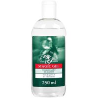
Grand National Magic gel

0
* De Grand National Magic gel * Zorgt ervoor dat staart en/of manen weer doorkambaar worden en verwijdert klitten * Het geeft een zijde-achtige glans * Kan aangebracht worden op zowel droog als nat haar...
Kies een maat
  • n.v.t.

Verkopers met dit product

Verkoper
Bezorging
Prijs
Divoza.com logo
Divoza.com
2 dagen
4,99
15,95

Anderen bekeken ook

Wandelkaart 202 Grand Teton National Park | National Geographic
Prachtige geplastificeerde kaart van het bekende nationaal park. Met alle recreatieve voorzieningen als campsites, maar ook met topografische details en wandelroutes ed. Door uitgekiend kleurgebruik zeer prettig in gebruik. Scheur en watervast! De meeste kaarten hebben een UTM grid en zijn dan ook GPS toepasbaar. Coverage includes town of Lead, Sturgis, Fort Meade Recreation Area, Black Hills Experimental Forest, Deerfield LakeCoverage includes Caribou Targhee National Forest, Jedediah Smith Wilderness, Bridger Teton National Forest, John D. Rockefeller Jr. Memorial Parkway, and Gros Ventre Wilderness. Ski areas: Jackson Hole Mountain Resort; Snow King Mountain; Grand Targhee Resort. Towns: Colter Bay Village; Jackson.  
16,95
Lucky Horse Unicorn Magic Gel 100 ml
Magic Gel is een uitstekende ontklitter en houdt de staart en manen lang doorkambaar. Het zorgt voor een prachtig volume en een schitterende glans. De gel plakt niet en heeft een vuilafstotende werking. Magic Gel laat je pony of paard shinen als een topmodel. GebruiksaanwijzingVerdeel een kleine hoeveelheid gel in de handpalm en masseer het in de staart en manen. Even laten inwerken en daarna de staart en manen borstelen. Je kunt Magic Gel ook gebruiken om het lijf van je pony of paard een fantastische glans te geven. Niet gebruiken onder het zadel. BewaringVorstvrij en op kamertemperatuur.Inhoud100 ml 
9,95
Reisgids - Wandelgids Grand Canyon National Park | Lonely Planet
Uitstekende gids over dit specifieke park met alle dingen die je er kunt doen. Veel praktische adressen en kaartjes, goede beschrijvingen etc. Lonely Planet's Grand Canyon National Parks is your passport to the most relevant, up-to-date advice on what to see and skip. Hike the Hermit trail, swim in Oak Creek, and ride the Colorado river; all with your trusted travel companion. Get to the heart of Grand Canyon National Parks and begin your journey now!   Inside the Lonely Planet's Grand Canyon National Parks Travel Guide:   User-friendly highlights and itineraries help you tailor your trip to your personal needs and interests   Insider tips to save time and money and get around like a local, avoiding crowds and trouble spots   Essential info at your fingertips - hours of operation, phone numbers, websites, transit tips, prices, emergency information, park seasonality, hiking trail junctions, viewpoints, landscapes, elevations, distances, difficulty levels, and durations   F…
23,95
Wandelkaart 262 Grand Canyon East - Oost | National Geographic
Prachtige geplastificeerde kaart van het nationaal park. Met alle recreatieve voorzieningen als campsites, maar ook met topografische details en wandelroutes ed. Door uitgekiend kleurgebruik zeer prettig in gebruik. Scheur en watervast! Grand Canyon East (#262) and Grand Canyon West (#263) combine to cover the entire Grand Canyon National Park and its bordering public lands. Both maps contain detailed and easy-to-read trail and road networks, locations of facilities, points of interest, and highly accurate terrain with thousands of feature names. Official Grand Canyon Backcountry Use Areas are shown, coded by degree of experience required. Suggested hikes and itineraries, important park regulations, safety tips and contact information make these maps an invaluable resource. Grand Canyon East (#262) contains detailed coverage from the park’s northeastern boundary at Glen Canyon to the highly visited areas just west of Grand Canyon village on the south rim (Colorado River miles 0 – 142)…
16,95
Wandelkaart - Topografische kaart 263 Grand Canyon West | National Geographic
Prachtige geplastificeerde kaart van het nationaal park. Met alle recreatieve voorzieningen als campsites, maar ook met topografische details en wandelroutes ed. Door uitgekiend kleurgebruik zeer prettig in gebruik. Scheur en watervast! National Geographic's Trails Illustrated map of Grand Canyon West covers some of the less frequented but just as wondrous landscape of Grand Canyon National Park, from Powell Plateau to the park's western boundary. Expertly researched and created in partnership with the National Park Service, U.S. Forest Service, Bureau of Land Management and others, the map also covers the surrounding areas of Kaibab National Forest, Hualapai Havasupai Indian Reservations and Parashant National Monument. With so much of the area being backcountry, the map also includes useful backcountry information, regulations and safety tips, in addition to a backcountry use area guide, color-coded by degree of experience required.   Clearly marked trails, including unmaintained pr…
16,95
Wandelkaart - Topografische kaart 261 Grand Canyon | National Geographic
Prachtige geplastificeerde kaart van het bekende nationaal park. Met alle recreatieve voorzieningen als campsites, maar ook met topografische details en wandelroutes ed. Door uitgekiend kleurgebruik zeer prettig in gebruik. Scheur en watervast!   Explore the uniquely inspiring and wondrous landscape of the Grand Canyon with National Geographic's Trails Illustrated map of Grand Canyon National Park, North and South Rims. Expertly researched and created in partnership with local land management agencies, this map is designed to meet the needs of outdoor enthusiasts with unmatched detail of the heart of the park. Key areas of interest featured on this map include Colorado River miles 60-98, North and South Rim visitor centers, Grand Canyon Village, Tusayan, Bright Angel Trail (plus elevation profile), West Rim Trail, Kaibab Trail, Arizona Trail, and more.   With miles of mapped trails in some of the most breathtaking scenery in the entire country, the Grand Canyon North and South Rims ma…
16,95

Klanten-reviews van Grand National Magic gel

Er zijn nog geen beoordelingen voor dit productBen jij de eerste die een review plaatst?

Meer over Grand National Magic gel

Productomschrijving

* De Grand National Magic gel * Zorgt ervoor dat staart en/of manen weer doorkambaar worden en verwijdert klitten * Het geeft een zijde-achtige glans * Kan aangebracht worden op zowel droog als nat haar

Productinformatie

    Productspecificaties

    Artikelnummer(s)
    EAN
    8712146660308
    Brand
    Grand National

    Verken gerelateerde categorieën

    Webshop.nl maakt gebruik van cookies. Ga je verder op onze website, ga dan akkoord met het plaatsen van cookies en de verwerking van deze data door ons en vermelde partners.