webshop.nl

Fotoboek Map | Phaidon

0
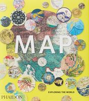
300 stunning maps from all periods and from all around the world, exploring and revealing what maps tell us about history and ourselves. Map: Exploring the World brings together more than 300 fascinating maps from the birth of cartography to cutting-edge digital maps of the twenty-fist century. The book's unique arrangement, with the maps organize...

Webshops met dit product

Webshop
Bezorging
Prijs
DeZwerver.nl logo
DeZwerver.nl
niet bekend
51,50

Anderen bekeken ook

Wandelkaart - Topografische kaart 124 OS Explorer Map Hastings & Bexhill | Ordnance Survey
Experience the history-rich countryside where the High Weald, an Area of Outstanding Natural Beauty, sweeps down to the shore where the fate of Britain was decided in 1066. Explore Battle and visit the actual spot where the Battle of Hastings took place, now a beautiful wildflower meadow dotted with the ruins of a grand abbey built in penance for the slaughter.  Visit the seaside towns of Hastings and Bexhill with their medieval Old Towns, Victorian and Edwardian seafronts and pavilions  Glimpse wild deer and boar roaming in the forests near Robertsbridge and Dartwell Reservoir in the High Weald  Walk or cycle in the footsteps of William the Conqueror on the 1066 Path, or start the Saxon Shore Way from Hastings to head north to Winchelsea  Met zijn 4cm voor 1 km (2 ½ cm voor 1 mijl) schaal, is de OS Explorer kaartenserie de ideale en meest gedetailleerde kaartenreeks voor mensen die graag outdoor-activiteiten zoals fietsen, wandelen, paardrijden, klimmen en watersporten. Deze kaart…
19,50
Wandelgids Thames Path | Trailblazer Guides
This book follows the Thames Path National Trail from the river's source in Gloucestershire to the Thames Barrier in London. Officially 184 miles (294km) in length (although the actual distance you walk will depend on a number of decisions you make en route), the path meanders, accompanied by its watery muse, through pristine and tranquil countryside, past historic sites and buildings, via pub, lock, weir, and the occasional scattering of waterfowl, to a city, once the fulcrum of an empire, and now the heart of modern day England. The river, responsible for the metropolis' very being, tells tales, inspires artists, accommodates swans, geese, and water voles, reflects the silhouettes of red kites and kingfishers, provides employment, entices adventure, and allows time for carefree pilgrims to procrastinate and think. Following its banks is a grand way to go for a ramble. The path begins, as the river does, in a meadow in the Cotswolds; its upper reaches lonely and wild, the meadows and…
19,95
Reisgids Mini Rough Guide Porto | Rough Guides
This pocket-sized guide is a convenient, quick-reference companion to discovering what to do, what to see and how to get around Porto. It covers top attractions like Torre Dos Clerigos, Port Wine Cellars, The Se, Igreja de Sao Francisco, Placio da Bolsa, Jardim do Palacio de Cristal or City of Bridges. This will save you time, and enhance your exploration of this fascinating Porto. This title has been fully updated post-COVID-19. This Mini Rough Guide to Porto covers Ribeira, the Se, Baixa, Miragai and Massarelos, Boavista and Serralves, Vila Nowa de Gaia In this travel guide you will find: RECOMMENDATIONS FOR EVERY TYPE OF TRAVELLER Experiences selected for every kind of trip to Porto, from cultural explorations in Baixa to family activities in child-friendly places, like World of Discoveries, Sea Life and Jardim do Palácio de Cristal or chilled-out breaks in popular tourist areas like Cais da Ribeira TOP TEN ATTRACTIONS Covers the destination's top ten attractions not to miss, incl…
12,50
Reisgids Virginia including Washington DC | Moon Travel Guides
De Amerikaanse uitgever Moon is een vergelijkbare gids met uitgever Lonely Planet > veel praktische informatie met veel diepgang! Het feit dat het een Amerikaanse uitgever is, maken deze gidsen zeer aantrekkelijk voor de staten afzonderlijk. De Lonely Planet haalt dat nivo niet! From metropolitan cities and misty mountains to colorful coastline and charming small towns, journey through the Old Dominion state with Moon Virginia. Inside you'll find:* Flexible itineraries, such as five days visiting Virginia's battlefields and breweries and ten days exploring the whole state, with detailed coverage of Washington DC* The best road trips in Virginia, including the scenic Skyline Drive and the Blue Ridge Parkway* Strategic advice for history buffs, foodies, outdoor adventurers, families, and more* Can't-miss sights and unique experiences: Visit Revolutionary War battlefields and hear the stories behind Civil War landmarks or immerse yourself in history in Colonial Williamsburg. Stroll the V…
20,95
Reisgids USA The Rockies | Insight Guides
Een rijk geillustreerde reisgids met diepgaande teksten: één van de beste reisgidsen die er bestaan. Eerste deel bestaat uit een beschrijving van de unieke aspecten van de regio, daarna een deel echte reisgids en als afsluiting een deel met praktische informatie. De uitstekende informatie wordt vergezeld van prachtige foto's en heldere kaarten. Niet alleen om mee te nemen, maar ook om vooraf en zelfs achteraf weer in de stemming te komen. This Insight Guide is a lavishly illustrated inspirational travel guide to USA The Rockies and a beautiful souvenir of your trip. Perfect for travellers looking for a deeper dive into the destination's history and culture, it's ideal to inspire and help you plan your travels. With its great selection of places to see and colourful magazine-style layout, this USA The Rockies guidebook is just the tool you need to accompany you before or during your trip. Whether it's deciding when to go, choosing what to see or creating a travel plan to cover key plac…
24,95
Reisgids Mini Rough Guide Antigua & Barbuda | Rough Guides
Een kleinere versie in zakformaat van de grotere versies van de Rough Guides. Als altijd weer vol met goede informatie over cultuur en praktische zaken. Achterin kleine plattegronden. This pocket-sized guide is a convenient, quick-reference companion to discovering what to do, what to see and how to get around Antigua & Barbuda. It covers top attractions like the Cathedral of St John the Divine, Radcliffe Quay and Nelson's Dockyard, as well as hidden gems, including a trip to Betty's Hope, Antigua's first sugar plantation and a valuable heritage site, a relaxing day at Half Moon Bay, considered to be one of the best in the world, and a boat ride to Great Bird Island, where birdwatching, picnics on the pristine beach and snorkeling in crystal clear waters is par for the course. This will save you time, and enhance your exploration of this fascinating islands. This title has been fully updated post-COVID-19.   This Mini Rough Guide to Antigua & Barbuda covers: St John's; The north coast…
12,50
Reisgids Puerto Vallarta | Moon Travel Guides
De Amerikaanse uitgever Moon is een vergelijkbare gids met uitgever Lonely Planet > veel praktische informatie met veel diepgang! Het feit dat het een Amerikaanse uitgever is, maken deze gidsen zeer aantrekkelijk voor de staten en nabije landen afzonderlijk. De Lonely Planet haalt dat nivo niet! Towering mountains and turquoise sea, street food and cutting-edge cuisine, old-world vibes and world-class luxury: Explore a tropical paradise full of surprises with Moon Puerto Vallarta. Inside you'll find:- Strategic, flexible itineraries with ideas for outdoor adventurers, beach bums, surfers, budget travellers, wellness seekers, and more, including a Costalegre road trip- The top outdoor adventures: Snorkel in the crystal-clear ocean, spot humpback whales and sea turtles out on the bay, or take a surfing lesson. Catch a sunset on the beach, go stand-up paddle boarding, or escape to the misty Sierra Madres for a hike- Must-see highlights and unique experiences: Enjoy tacos from a street …
22,50
Reisboek - Wandelgids Wild Swimming Walks Peak District | Wild Things Publishing
The best-selling Wild Swimming Walks series returns with adventures in Britain's oldest National Park. Ascend to the highest tarns and descend through a valley of secret waterfalls * Walk through woodland gorges carved by cascades * Follow bucolic river valleys dipping as you walk. Wild Swimming Walks Peak Disitrict leads you on 28 adventures in the soaring landscape of the Peak District. Find secret waterfalls, remote lakes and sparkling river pools. Complete with photos, maps and practical guidance, rich in local history and stories, this book will appeal to wild swimmers, family explorers, nature lovers and walkers alike.   JOIN THE ADVENTURE with the best-selling Wild Swimming Walks series and explore Britain’s oldest national park from the gritstone edges of the Hope Valley, to the magical streams on the moorlands of Bleaklow, through to the picturesque limestone river dales of the White Peak.   Scramble up streams and waterfalls at Black Clough Explore fairy pools and mossy…
20,95
Reisgids Eyewitness Travel Southwest USA and National Parks | Dorling Kindersley
Prachtig geillustreerde reisgids met o.a. 3D tekeningen, fraaie kaarten en geweldige foto’s. Daarnaast uitgebreide achtergrondbeschrijvingen. Echt om in de stemming te komen! Groot formaat gids. Engelstalig. Embark on an outdoor adventure across the Southwest USA and its many varied and wonderful National Parks! Whether you want to unleash your inner cowboy on the ranches in Utah, take in the truly spectacular sight of the Grand Canyon, or test your luck in the casinos of Las Vegas, your DK Eyewitness travel guide makes sure you experience it all! Inside the pages of this Southwest USA and National Parks travel guide, you’ll discover:    • Our pick of Southwest USA’s must-sees, top experiences, hidden gems, and the best spots to eat, drink, shop, and stay     • Detailed maps and walks make navigating the cities and towns easy     • Easy-to-follow itineraries to help you plan your trip    • Expert advice and travel tips to help you get ready, get around and stay safe    • Color-coded…
20,95
Wandelkaart - Topografische kaart 172 OS Explorer Map Chiltern Hills East | Ordnance Survey
Discover the east Chiltern Hills where they meet the Thames Valley, replete with lovely countryside, beautiful views and rich history. Delight in the unrivalled sailing reaches of Maidenhead; the Georgian architecture of High Wycome, the onetime furniture capital of England and the market town of Rickmansworth, set in beautiful country but a stone’s throw from London.    Bathe in natural beauty, from carpets of bluebells in the beech woods to red kites on the chalk grasslands and wildflower meadows where rare butterflies like the Adonis Blue flutter  Discover stately homes and historic houses including the gorgeous Italianate mansion of Clevedon, the charming Tudor manor Chenies and Milton’s Cottage where Paradise Lost was finished  Walk, cycle or hike a wide range of recreational paths including the Chiltern Way, South Bucks Way, Shakespeare’s Way and the Thames Path  Met zijn 4cm voor 1 km (2 ½ cm voor 1 mijl) schaal, is de OS Explorer kaartenserie de ideale en meest gedetailleer…
19,50

Klanten-reviews van Fotoboek Map | Phaidon

Er zijn nog geen beoordelingen voor dit productBen jij de eerste die een review plaatst?

Meer over Fotoboek Map | Phaidon

Productomschrijving

300 stunning maps from all periods and from all around the world, exploring and revealing what maps tell us about history and ourselves.

Map: Exploring the World brings together more than 300 fascinating maps from the birth of cartography to cutting-edge digital maps of the twenty-fist century. The book's unique arrangement, with the maps organized in complimentary or contrasting pairs, reveals how the history of our attempts to make flat representations of the world has been full of beauty, ingenuity and innovation.

Selected by an international panel of curators, academics and collectors, the maps reflect the many reasons people make maps, such as to find their way, to assert ownership, to record human activity, to establish control, to encourage settlement, to plan military campaigns or to show political power. The selection includes the greatest names in cartography, such as James Cook, Gerard Mercator, Matthew Fontaine Maury and Phyllis Pearsall, as well as maps from indigenous cultures around the world, rarely seen maps from lesser'known cartographers, and maps of outstanding beauty and surprising individuality from the current generation of map makers.

Verken gerelateerde categorieën

Webshop.nl maakt gebruik van cookies. Ga je verder op onze website, ga dan akkoord met het plaatsen van cookies en de verwerking van deze data door ons en vermelde partners.