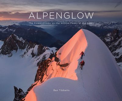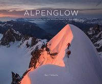
Fotoboek Alpenglow - The Finest Climbs on the 4000m Peaks of the Alps | Benn Tibbetts

0
ALPENGLOW takes the reader through a journey of personal adventure, immersive art and breathtaking scenery, combining inspiration with detailed local knowledge. Climbing the 4000m peaks of the Alps is one of the great and enduring challenges in mountaineering. It is a project that requires endurance, courage, skill, and humility.   Whether you are...

Verkopers met dit product

Webshop
Bezorging
Prijs
DeZwerver.nl logo
DeZwerver.nl
niet bekend
68,95

Anderen bekeken ook

Fotoboek - Reisgids National Parks of America | Lonely Planet
Hardcover fotoboek met reisinformatie van alle 59 nationale parken van Amerika. Perfect ter inspiratie voor de volgende reis. To celebrate America's amazing national parks, Lonely Planet, the world's leading travel publisher, takes you on an informative and gorgeous tour of all 59 parks with our lavishly finished hardcover gift guide packed with detailed itineraries and practical tips on what to do and see in each park to get you started planning your next adventure. America's national parks are full of timeless marvels that still rejuvenate the soul: the world's largest trees in Sequoia; its most spectacular geothermal site in Yellowstone; the grandest canyon. Perhaps the movement's most eloquent description that is still resonates came from national parks advocate John Muir: 'Thousands of tired, nerve-shaken, over-civilized people are beginning to find out that going to the mountains is going home; that wildness is a necessity...' Fortunately for the nerve-shaken, over-civilized peo…
27,95
Fietsgids - Fotoboek Epic Bike Rides of the Americas | Lonely Planet
Een prachtig boek voor de avontuurlijke fietser: meer fotoboek dan echte fietsgids, maar enorm inspirerend. Voor een beetje fietser - of het nu en recreatieve fietser is of een ware fanaticus - het ideale kado!   Get ready to explore America’s most thrilling gravel, road and trail bike routes.   This definitive companion for cycling enthusiasts showcases 200 of North, Central and South America’s best and most celebrated routes, from epic adventures off the beaten path to shorter urban rides. Go bikepacking in Baja, road riding in Colombia, mountain biking in Canada and gravel riding in Pennsylvania.    Each ride is accompanied by stunning photos and a map and toolkit of practical details – where to start and finish, how to get there, where to stay and more – to help you plan the perfect trip. Suggestions for similar rides around the world are also included.   Rides in Canada include:   The Cabot Trail (Nova Scotia) Whistler Bike Park (British Columbia) The Whitehorse Trails (Yukon)…
34,95
Reisinspiratieboek - Reisboek Book of the Alps | Marmota Maps
The Book of the Alps  the great illustrated book about the Alps.290 pages with over 1000 illustrations, graphics, and maps on geography, sports, history, culture, climate, environment and much more. Understand the Alps like never before.Created in cooperation with the Alpine clubs of Germany, Austria, and South Tyrol. CONTENTS The Book of the Alps has 46 chapters in seven subject areas: Geography   Flora and Fauna   Climate and Environment    Alpinism   Mountain Sports   Society and Economy   Arts and Culture   GEOGRAPHY Geological Formation Ice Age Mountains Valleys Mountain Passes Lakes and Rivers Glaciers The Alps are unique. How did they form and evolve? How do glaciers, passes, valleys, lakes, and rivers shape the landscape? Answers to these and many more questions can be found in the geography chapter.   FLORA AND FAUNA Biodiversity Plants Forests Animals National Parks The Alpine environment is fascinating. Alpine flowers such as the edelweiss and Alpine anima…
44,95
Reisgids - Fotoboek Epic Hikes of the World | Lonely Planet
With stories of 50 incredible hiking routes in 30 countries, from New Zealand to Peru, plus a further 150 suggestions, Lonely Planet's Epic Hikes of the World will inspire a lifetime of adventure on foot. From one-day jaunts and urban trails to month-long thru-hikes, cultural rambles and mountain expeditions, each journey shares one defining feature: being truly epic. In this follow-up to Epic Bike Rides and Epic Drives, we share our adventures on the world's best treks and trails. Epic Hikes is organised by continent, with each route brought to life by a first-person account, beautiful photographs and charming illustrated maps. Additionally, each hike includes trip planning advice on how to get there, where to stay, what to pack and where to eat, as well as recommendations for three similar hikes in other regions of the world. Hikes featured include: Africa & the Middle East: Cape Town's Three Peaks (South Africa) Kilimanjaro (Tanzania) Camp to Camp in South Luangwa National Park …
21,95
Fotoboek Let's Get Lost | White Lion Publishing
Get away from it all and reignite your wanderlust with this unique collection of epic landscape photography from some of the remotest and most spectacular locations around the globe. Curated by award-winning travel and lifestyle photographer Finn Beales, Let’s Get Lost offers pure visual escapism with over 200 spectacular shots of remote and beautiful places which will inspire you to get back out into the world after months and years of lockdowns and travel restrictions. For the adventurous amongst us, this book dares you to get off the beaten track andgo in search of the most remarkable natural environments on the planet. Chapters capturing off-grid coastal views, rugged mountain landscapes, majestic forests and expansive wildernesses are all featured, stirring within you a sense of adventure. From the Pacific Northwest to Southeast Asia, New Zealand to Scandinavia, these are the places where amazing photos are taken, now you need to experience them. For the armchair traveller, th…
34,95
Atlas The Phantom Atlas | Simon & Schuster
Een fascinerend boekwerk met de grootste mythes, leugens en blunders die ooit op kaart zijn verschenen. In een luxe hardcover uitgave met mooie stofomslag. The Phantom Atlas is an atlas of the world not as it ever existed, but as it was thought to be. These marvellous and mysterious phantoms - non-existent islands, invented mountain ranges, mythical civilisations and other fictitious geography - were all at various times presented as facts on maps and atlases. This book is a collection of striking antique maps that display the most erroneous cartography, with each illustration accompanied by the story behind it. Exploration, map-making and mythology are all brought together to create a colourful tapestry of monsters, heroes and volcanoes; swindlers, mirages and murderers. Sometimes the stories are almost impossible to believe, and remarkably, some of the errors were still on display in maps published in the 21st century. Throughout much of the 19th century more than 40 different mapma…
34,95
Natuurgids - Reisgids Crossbill Guides Southern Morocco - Zuid Marokko | KNNV Uitgeverij
Zeer gedegen natuurgids van het betreffende gebied. Unieke gids met streekinformatie, plekken waar je echt  moet zijn, routes en veel achtergrondinformatie over het landschap, de ecologie, ontstaansgeschiedenis en de flora en fauna. De routes en plekken die beschreven worden in de gids zijn zo gekozen dat je een heel compleet beeld krijgt van het gebied: landschappelijk, flora en fauna ... alle toppers van de streek zijn goed te vinden. Echt een aanrader voor elke natuurliefhebbers die zich wat meer in het gebied wil verdiepen.   This nature travel guidebook to Southern Morocco contains routes and background info on landscape, flora and fauna.   Landscape history Ecosystems Geology Flora and Fauna Where to watch birds Finding mammals, reptiles, butterflies, dragonflies and wildflowers 25 detailed routes with tips for finding wildlife and 29 site descriptions   Region covered by this Crossbill Guide The Crossbill Guide Southern Morocco covers the part of Morocco that lies ro…
29,95
Fotoboek Great Hiking Trails of the World | Rizzoli International
FOREWORD INDIES Book of the Year Awards -- 2017 GOLD Winner for Nature A hiker's dream bucket list is embodied in this lavishly illustrated celebration of more than eighty of the world's most iconic trails. Celebrating the most important, popular, and diverse hiking trails in the world, this book invites readers to take a walking tour through the planet's natural wonders. Divided into six sections, the book groups trails by theme: pilgrimages, historic hikes, mountain hikes, wilderness trails, trails through diverse environments, and long-distance trails. From Mount Kenya to subarctic hikes in Scandinavia, and from exotic hikes in the Himalayas to more familiar trails in the United States and Canada, this book invites readers to explore the history, environment, and cultures of the world on foot. Each featured trail has its own section, with a map and photo gallery focusing on what makes it one of the most magnificent hiking trails anywhere in the world. Included are detailed descr…
42,95
Fietskaart 10 Cycling guides North York Moors | Goldeneye
Scheur- en watervast foetskaart van de North York Moors  met ingetekende fietsroutes.   Our maps are double-sided, printed on an A2 sheet with a concertina fold. This allows for easy folding and folding, and an ease of access to the mapping. The material is rain and tear-resistant. Our early maps were designed at the scale of 2 miles to 1 inch/1:126,720. The later designs along with digitalisation are 1: 100,000. We were encouraged by the Cycle Touring Club to convert our cartography toward the cycle market (to replace the out-of-print Bartholomew series). As time and the series progressed we have added more data: The National Cycle Network routes, Regional Routes, and Traffic-Free Family Routes, as and when they are developed. These routes are in addition to the Circular Routes Goldeneye Commissioned at the outset of our publishing schedule. We are also adding to new editions; bike shops, cycle hire, and tea rooms, along with the tourist attractions already featured. Our plan is to m…
14,95
Fotoboek Cyclades | teNeues
- The first and only comprehensive illustrated book on the Cyclades Islands, portraying all the islands in all seasons - Not your typical travel book capturing only the tourist hotspots of the islands, but a book that captures the land and people, the soul of the archipelago The first comprehensive illustrated book on the Cyclades archipelago, which also includes the well-known islands of Santorini, Naxos, Paros and Mykonos. The islands are currently among the trendiest travel destinations in the world. There is no Hollywood or Instagram star who has not been photographed in front of the white cities of the Greek islands. This illustrated book attempts to capture the islands' attitude to life in an undisguised way. In doing so, the volume does not aim at the big tourist hotspots and Instagram shots that can be seen everywhere else, but would like to capture the Greek island world as a whole - with all its discrepancies. Lonely bays and half-ruined towns stand next to the glossy world …
44,95

Klanten-reviews van Fotoboek Alpenglow - The Finest Climbs on the 4000m Peaks of the Alps | Benn Tibbetts

Er zijn nog geen beoordelingen voor dit productBen jij de eerste die een review plaatst?

Meer over Fotoboek Alpenglow - The Finest Climbs on the 4000m Peaks of the Alps | Benn Tibbetts

Productomschrijving

ALPENGLOW takes the reader through a journey of personal adventure, immersive art and breathtaking scenery, combining inspiration with detailed local knowledge. Climbing the 4000m peaks of the Alps is one of the great and enduring challenges in mountaineering. It is a project that requires endurance, courage, skill, and humility.   Whether you are a lover of mountain landscapes, an aspiring alpinist, or already a veteran of many adventures, this book will provide a wealth of original and inspiring material to help with planning future excursions or simply immersing yourself in the beauty of the high mountain   Drawings The photography in the book is matched by a series of finely wrought pencil drawings. Several of these are available as luxury prints to complement the book.   Finsteraarhorn pencil drawing (12 x 8 cm) example   The drawings for this project are usually smaller than a typical postcard. Each one is based on photographs and made with finely-sharpened pencils whilst looking through a magnifying glass.   I usually start each layer of detail from one side and work steadily to the other to avoid smudging the fragile image with my hands. I rarely use an eraser as once the marks are made they are too small and fragile to modify. Each drawing takes between 2 and 10 weeks to complete.
  • Climbs on all 82 of the 4000m summits of the Alps
  • Unique PENCIL DRAWINGS 
  • ACTION PHOTOS of every route 
  • Exquisite LANDSCAPE IMAGES of each mountain 
  • The author has climbed each route 
  • TOPO DESCRIPTIONS and details of optimal climbing conditions 
  • 50 routes – 320 pages, 30×25 cm, 2.2kg
  • 190 photos and 25 drawings


Verken gerelateerde categorieën

Webshop.nl maakt gebruik van cookies. Ga je verder op onze website, ga dan akkoord met het plaatsen van cookies en de verwerking van deze data door ons en vermelde partners.