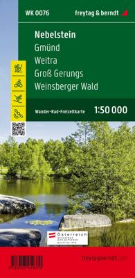
Fietskaart - Wandelkaart 076 Nebelstein - Gmünd - Weitra - Gross Gerungs | Freytag & Berndt

0
The Nebelstein hiking map on a scale of 1:50,000 is the ideal companion for excursions, hikes and bike tours in the Oberes Waldviertel, Waldviertel Mitte and Mühlviertler Alm Freistadt regions Lainsitz, the Castles and Castles Trail, the St. John's Trail and the Life Trail. The hiking trails on the map are easy to follow thanks to the exact cartog...

Verkopers met dit product

Verkoper
Bezorging
Prijs
DeZwerver.nl logo
DeZwerver.nl
2,95
13,95

Anderen bekeken ook

Nieuw
Wandelkaart 17 Banff - Egypt Lake | Gem Trek Maps
Mooie, gedetailleerde kaart uit de serie van Gem Trek Hiking map-guides. Helder kleurgebruik en met de beste / mooiste wandelroutes, hikes en interessante plaatsen erop aangegeven. Gem Trek’s 1:50,000-scale BANFF–EGYPT LAKE MAP covers the most popular hiking trails in the immediate area of the town of Banff in more detail than our Banff & Mount Assiniboine Map.   The Banff–Egypt Lake Map features detailed cartography, accurate hiking trails with distances, and details such as side trips and backcountry campgrounds. For road travellers, it includes viewpoints, picnic areas, and campgrounds.   On the back of the map are trail descriptions of 17 recommended day hikes and four classic multi-day trips, all referenced to the map on the front. Also on the back is a list of trails recommended for early season, birdwatching, wildflowers, waterfalls, expansive views, awe-inspiring scenery, alpine meadows and rainy days. Included are contact numbers for visitor centres and backcountry booki…
17,95
Nieuw
Wandelkaart 03 Bow Lake / Saskatchewan Crossing | Gem Trek Maps
Waterproof and tear-resistant hiking and recreation map for the Bow Lake and Saskatchewan Crossing region of Banff National Park.   Gem Trek's 1:70,000 Bow Lake and Saskatchewan Crossing Map is designed for outdoor enthusiasts looking to explore the Bow Lake and Saskatchewan Crossing region at the north end of Banff National Park. Whether you are touring along the roads or heading into the backcountry, you’ll find the waterproof and tear-resistant Bow Lake and Saskatchewan Crossing Map to be an invaluable tool. This map features detailed cartography, accurate hiking trails with distances, and details such as logging roads on the British Columbia side of the Continental Divide, campgrounds, picnic areas, and abandoned fire lookouts. On the back are descriptions of 24 recommended hikes, ranging from short walks to overnight treks, as well as details of services such as campgrounds and visitor centres.   Map specs     – Edition: 6th – Map scale: 1:70,000 – Sheet size: 27 x 39 inches – Fo…
18,95
Wandelkaart 01 Jasper National Park & Maligne Lake | Gem Trek Maps
Scheur- en Watervast papier Gem Trek’s JASPER AND MALIGNE LAKE MAP map is designed for outdoor enthusiasts looking to explore the section of Jasper National Park near the town and out to Maligne Lake. Whether you are touring along the roads or heading into the backcountry, you’ll find the waterproof and tear-resistant Jasper & Maligne Lake Map to be an invaluable tool.   This map features detailed cartography, accurate hiking trails with distances, and details such as campgrounds, equestrian routes, picnic areas, and fire lookouts. On the back of the map are trail descriptions and photos of 18 recommended day hikes, four overnight or multi-day trips, and six classic mountain bike rides. Each of these described trails is referenced and colour-coded to the map on the front. Also on the back is contact information for Jasper National Park, as well for as the three backcountry lodges located in the Tonquin Valley and on the Skyline Trail.   Jasper & Maligne Lake Map Coverage The Jas…
16,95
Nieuw
Wandelkaart 15 Canmore Up-Close | Gem Trek Maps
Waterproof and tear-resistant hiking and recreation map for the town of Canmore and surrounds in the Canadian Rockies.   Designed for both locals and visitors, Gem Trek’s 1:35,000 Canmore Up-Close Map is a detailed relief-shaded topographic map of Canmore and the Bow Valley area. This edition has been updated to show all new subdivisions and recent changes to the trail network. On the back of the Canmore Up-Close Map are descriptions of recommended sights and detailed descriptions of the best and most scenic hiking and biking trails, including the highlights of each trail, as well as distance, elevation gain and directions to the trailhead. Also on the back of the map is an inset map of downtown Canmore and colour photos.   Map specs   Edition: 2nd Scale: 1:35,000 Folded size: 4.5 x 9.5 inches Flat size: 18 x 24 inches Paper: Waterproof and tear-resistant   Map coverage   The Canmore Up-Close Map focuses on the town of Canmore in the Canadian Rockies. The map boundary extends along th…
13,95
Nieuw
Wandelkaart 2 Cinque Terre - Portofino | Freytag & Berndt
Goede wandelkaart van het beroemde Cinque Terre. Fietsroutes, wandelroutes en enkele mountainbike-tochten staan er op ingetekend. GPS - bruikbaar.   Explore the Italian coastline known as Cinque Terre and the fishing village of Portofino with this Freytag & Berndt travel set. Inside the plastic sleeve, you will find a hiking and leisure map; as well as a guide. The best way to plan your trip, prepare your itinerary, and to travel independently on this region. As with all Freytag & Berndt maps, the cartography is clear and detailed with the topography shown with relief shading with plenty of spot heights.   The hiking and leisure map includes an inset of the village of Portofino. Tourist information is marked clearly using a range of icons and markings. Tourist information displayed includes:   Roadways, footpaths, bridle paths, railway, shipping routes, moutain biking paths and hiking trails Restaurants, churches, and other buildings of interest Camping sites, caves, golf courses, inf…
13,95
Wandelkaart - Wegenkaart - landkaart La Palma | Freytag & Berndt
Goede overzichtskaart van La Palma. Juist deze kaart is bij uitstek geschikt voor vele doeleinden. Zowel voor de auto als voor de aktieve vakantieganger goed.  Overigens vinden wij dat de Freytag & Berndt kaarten van de Spaanse en Portugese eilanden iets meer gericht zjin op algemeen toerisme en iets minder op wandelen; voor wandelen raden we toch de Kompass - kaarten serie aan die van de meest eilanden ook voor handen is.   The La Palma road map on a scale of 1:40,000 contains all the important information for holidaymakers who want to visit La Palma. The extensive road network is precisely represented and many tourist attractions are shown on the map. Drivers and motorcyclists particularly appreciate the precise cartography from freytag & berndt for route planning and on-site orientation. Hikers can also use the map for hiking tours thanks to the detailed scale and contour lines.   Information about the La Palma road map   Scale 1:40,000 Hiking trails Tourist information Innenstadtp…
14,95
Nieuw
Wandelkaart 07 Kananaskis Lakes | Gem Trek Maps
Waterproof and tear-resistant hiking and recreation map for the Kananaskis Lakes region of the Canadian Rockies   Gem Trek's Kananaskis Lakes Map is designed for hikers and outdoor enthusiasts looking to explore the south-central portion of Kananaskis Country immediately south of our Canmore and Kananaskis Village Map. Whether you are touring along the roads or heading into the backcountry, you'll find the waterproof and tear-resistant Kananaskis Lakes Map to be an invaluable tool.   This map features detailed cartography, accurate hiking trails with distances, and details such as logging roads, campgrounds, equestrian routes, picnic areas, and fire lookouts. On the back are descriptions of the most popular hiking trails, as well details of services such as campgrounds and visitor centres.   – Map scale: 1:50,000 – Sheet size: 27 x 39 inches – Folded size: 4.5 x 9.5 inches   Map Coverage   The Kananaskis Lakes Map covers Peter Lougheed Provincial Park, located off Highway 40 south of …
18,95
Wandelkaart Tour & Trail Gran Canaria | Discovery Walking Guides
Goede, scheur- en watervaste, wandelkaart van Gran Canaria.   Gran Canaria Tour & Trail Super-Durable Map covers the whole island at 50,000 scale  in a double sided map sheet of North and South with a generous overlap common to both North and South map sheets.   For the best adventures, use the best map.  Gran Canaria is a large island of dramatic landscapes. Gran Canaria Tour & Trail Super-Durable Map (50k scale) is a large 960mm by 700mm double sided map sheet which folds to its 235mm by 120mm pocket size. A special concertina map fold makes the map easy to unfold and refold in use.  Super-Durable means water-proof and tear-proof, simply wipe clean with a damp cloth if your map gets dirty. This map has a "2 Year Guarantee" covering adventurous use.   Gran Canaria North is on one side with South on the reverse side, while a generous common overlap minimises your map turning.    Now in its 5th edition Gran Canaria Tour & Trail Super-Durable Map, 50k scale, is the result o…
15,95
Nieuw
Wandelkaart 11 Banff Up-Close | Gem Trek Maps
Waterproof and tear-resistant hiking and recreation map for the town of Banff and surrounds in the Canadian Rockies.   Designed for both locals and visitors, Gem Trek’s 1:35,000 Banff Up-Close Map is a detailed relief-shaded topographic map of the Banff area. All hiking and biking trails are labeled, and distances are marked. Like all Gem Trek maps, the Banff Up-Close Map features detailed cartography and accurate hiking trails with distances, elevation gain, and directions to the trailhead noted. An inset on the back increases coverage of downtown Banff, with museums and all streets marked. Also on the flipside are descriptions of the sights, museums and scenic drives in Banff. We've also included a hand-picked list of the best seven walks and day hikes in the area. The highlights of each trail are noted, as well as distance, elevation gain and directions to the trailhead.   Map specs   Edition: 4th Scale: 1:35,000 Folded size: 4.5 x 9.5 inches Flat size: 18 x 24 inches Paper: Waterp…
13,95
Wandelkaart Tour & Trail Costa de Sol - Axarquia | Discovery Walking Guides
Goede wandelkaart van de omgeving Nerja - Competa in het binnenland. For better adventures, use the best map. Costa del Sol (Axarquia) Tour & Trail Super-Durable Map comes with a 2 year adventurous use wear and tear guarantee against splitting or falling apart, see Discovery Walking Guides website for details. From 1 April 2020 a free Custom Map digital edition for Garmin users is available to download from the Discovery Walking Guides website.   Our large 1:40,000 scale, combined with splitting the region into West and East sections with a generous overlap, produces double sided map whose total size is 840mm by 700mm that folds to a pocketable 240mm by 120mm. Costa del Sol (Axarquia) covers the region from Ventas de Zafarraya in the North-West to Almunecar in the South-East; approx 3 42'W to 4 08'W and 36 43'N to 36 58'N. You get the most detailed map of the region that is produced including our 'Tour & Trail' level of detail ranging from major roads to secondary roads to minor ro…
15,95

Klanten-reviews van Fietskaart - Wandelkaart 076 Nebelstein - Gmünd - Weitra - Gross Gerungs | Freytag & Berndt

Er zijn nog geen beoordelingen voor dit productBen jij de eerste die een review plaatst?

Meer over Fietskaart - Wandelkaart 076 Nebelstein - Gmünd - Weitra - Gross Gerungs | Freytag & Berndt

Productomschrijving

The Nebelstein hiking map on a scale of 1:50,000 is the ideal companion for excursions, hikes and bike tours in the Oberes Waldviertel, Waldviertel Mitte and Mühlviertler Alm Freistadt regions Lainsitz, the Castles and Castles Trail, the St. John's Trail and the Life Trail. The hiking trails on the map are easy to follow thanks to the exact cartography by freytag & berndt and the ideal scale. Also for cyclists and mountain bikersthe Nebelstein hiking map is very suitable. In addition to demanding mountain bike routes, the course of the Waldviertel cycle path and parts of the EuroVelo 13 - Iron Curtain Trail can also be followed. Information on the Nebelstein hiking map 1:50,000 Hiking and long-distance hiking trails Cycle paths and mountain bike tours Attractive excursion destinations With info guide GPX Tracks zum Download Waterproof and tear resistant 90 x 61 cm, double-sided Info guide The "short and compact" info guide offers a journey through the regions of the Upper Waldviertel, Waldviertel Mitte and Mühlviertler Alm Freistadt. In addition, he presents the Nebelstein as a prominent elevation in the Waldviertel, where several (long-distance) hiking trails start and others cross it or end on it. The landscapes of the Oberen Waldviertel and Unteren Mühlviertel as well as the Waldviertel Mitte region are very similar: it is hilly, densely wooded and full of mighty granite blocks that look as if a giant had scattered them across the country. While people in Weitra are still committed to the art of brewing, Gmünd enchants with its impressive sgraffito houses. In both the Nordwald Nature Park and the Blockheide Nature Park, hikers can unwind and enjoy the multifaceted landscape. Many castles and palaces are also worth a detour, such as Rosenau Castle or Rappottenstein Castle. For those who love nature, the Mühlviertler Alm Freistadt region is also a small paradise, where there are many vantage points along the hiking trails and several small museums and pilgrimage churches have opened their doors to visitors. Waterproof and tear-resistant The map is printed on a special waterproof and durable paper so that it can also be used for orientation on rainy days. Resource-saving production The map consists of 80% ground limestone. The production is much more resource-efficient than with conventional paper, since the consumption of water, wood and energy is significantly lower.  

Verken gerelateerde categorieën

Webshop.nl maakt gebruik van cookies. Ga je verder op onze website, ga dan akkoord met het plaatsen van cookies en de verwerking van deze data door ons en vermelde partners.