Fietskaart Reivers Cycle Routes | Northern Heritage Services

0
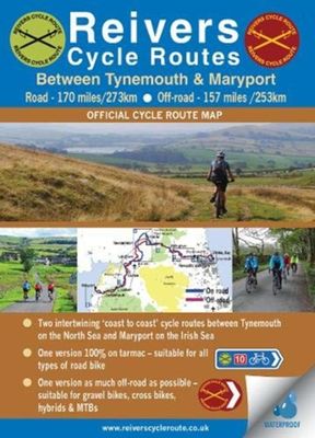
The long-distance Reivers Cycle Routes are two intertwining signed / waymarked bi-directional ‘coast to coast’ cycle routes between the North Sea and the Irish Sea.   The original Reivers Cycle Route was created in 1998 eventually becoming NCN Route 10 with interlinking on-road and off-road sections but this soon morphed into a one-size-fits-all r...

Verkopers met dit product

Webshop
Bezorging
Prijs
DeZwerver.nl logo
DeZwerver.nl
niet bekend
16,50

Anderen bekeken ook

Fietskaart 01 Cycling guides Cornwall | Goldeneye
Our maps are double-sided, printed on an A2 sheet with a concertina fold. This allows for easy folding and folding, and an ease of access to the mapping. The material is rain and tear-resistant. Our early maps were designed at the scale of 2 miles to 1 inch/1:126,720. The later designs along with digitalisation are 1: 100,000. We were encouraged by the Cycle Touring Club to convert our cartography toward the cycle market (to replace the out-of-print Bartholomew series). As time and the series progressed we have added more data: The National Cycle Network routes, Regional Routes, and Traffic-Free Family Routes, as and when they are developed. These routes are in addition to the Circular Routes Goldeneye Commissioned at the outset of our publishing schedule. We are also adding to new editions; bike shops, cycle hire, and tea rooms, along with the tourist attractions already featured. Our plan is to make available digital versions for cell phones and tablets and to update, on an annual b…
15,95
Fietskaart 14 Cycling guides Suffolk | Goldeneye
To be confronted with the variety and complexity of the cycling routes, trails and paths in Suffolk can be a bewildering experience.  For it appears that the Suffolk County Council and the three District Councils are all trying hard to promote their areas. This is indeed encouraging for the growth of cycling, but it can be confusing.  Our purpose is to provide clear, easy to use and easy to follow, cycling maps, and to illustrate these in a comprehensive form.    Suffolk must be one of the most charming of counties to explore by bicycle. When Al Churcher delivered his routes to us at Goldeneye we couldn’t keep him quiet, such was his enthusiasm and wonder at Suffolk’s country lanes and byways. He has cycled all over the UK, Canada, Mallorca, New Zealand and Sicily, but Suffolk remained a firm favourite.    The inland scenery is not spectacular for the county’s main glory lies with its attractive villages; the local architecture jealously preserved from modern depredation. There is an …
15,95
Fietskaart 09 Cycling guides Norfolk | Goldeneye
Norfolk is the fourth largest county in England and one of the most rural. It is also one of the flattest and our circular routes have been chosen to explore the quiet lanes linking the isolated and picturesque villages and places of interest. This is ideal cycling territory and fortunately, the Norfolk County Council (and its District Councils) are seriously committed in providing and developing cycling routes and in promoting a cycling culture that is sustainable and family friendly. Some of their routes are illustrated, hitherto.   The County has been described as flat (rather gentle undulations) and does not in fact rise much over 300 feet, but it offers great scenic interest; the dark forests of Breckland, the rolling chalk lands of the northwest, the unique watery patch of the Broads, and a coastline of great variety. Ancient churches and picturesque villages are there in abundance, the latter often decorated with the attractive signs designed by Harry Carter in the 1950’s.   Re…
14,95
Fietskaart Cycle Touring Map of Northumberland | Northern Heritage Services
The official planner for recreational cycling and cycle touring in Northumberland and beyond. Version 3 printed 2020.   Comprehensive list of promoted long distance cycle routes including: Coast and Castles Cycle Route, Pennine Cycleway, Hadrian’s Cycleway, Reivers Cycle Route, Sandstone Way and the C2C (Sea to Sea Cycle Route).   429 miles/851kms of long-distance cycle routes, including the 234 miles/377kms Grand Cycle Tour of Northumberland.   Revised and updated December 2020 - Recommended link routes between signed long distance routes.   Recommended road alternatives to avoid off-road sections of the National Cycle Network.   Comprehensive list of Local Day Rides; all available for sale or download at www.cyclenorthumberland.org.uk   Inset map featuring connections to and from Tyneside and main line stations and international ferry connections.   Mountain bike trails in Kielder Water & Forest Park.
14,95
Fietskaart Sandstone Way - Northumberland Cycle Route Map | Northern Heritage Services
The Sandstone Way is a 120-mile mountain biking route between Berwick upon Tweed and Hexham that runs along the sandstone ridge in North Northumberland, linking numerous sandstone crags and outcrops. From one end of Northumberland to the other, the Sandstone Way traverses an ever-changing landscape which is rich in history, geology and iconic scenery.   Both Hexham and Berwick upon Tweed are served by rail. Between these two towns, the route passes through numerous villages and small communities including Wooler, Rothbury and Bellingham. It has been designed to safely cross rivers, main roads and railways.   The Sandstone Way is designed for mountain bikers and as much of the route as possible is off-road. It will appeal to riders of all abilities and most will take 3 or 4 days to complete it. The ‘fit and the fast’ could possibly ride the route in 2 days but in all probability, most would wish they had taken 3 days. Almost certainly a few mountain bikers will try to ride the whole ro…
16,50
Fietskaart Cycling guides Exmoor - North Devon | Goldeneye
Scheur- en watervast foetskaart van Exmoor en Noord Devon met ingetekende fietsroutes.   Our maps are double-sided, printed on an A2 sheet with a concertina fold. This allows for easy folding and folding, and an ease of access to the mapping. The material is rain and tear-resistant. Our early maps were designed at the scale of 2 miles to 1 inch/1:126,720. The later designs along with digitalisation are 1: 100,000. We were encouraged by the Cycle Touring Club to convert our cartography toward the cycle market (to replace the out-of-print Bartholomew series). As time and the series progressed we have added more data: The National Cycle Network routes, Regional Routes, and Traffic-Free Family Routes, as and when they are developed. These routes are in addition to the Circular Routes Goldeneye Commissioned at the outset of our publishing schedule. We are also adding to new editions; bike shops, cycle hire, and tea rooms, along with the tourist attractions already featured. Our plan is to …
12,95
Fietskaart 10 Cycling guides North York Moors | Goldeneye
Scheur- en watervast foetskaart van de North York Moors  met ingetekende fietsroutes.   Our maps are double-sided, printed on an A2 sheet with a concertina fold. This allows for easy folding and folding, and an ease of access to the mapping. The material is rain and tear-resistant. Our early maps were designed at the scale of 2 miles to 1 inch/1:126,720. The later designs along with digitalisation are 1: 100,000. We were encouraged by the Cycle Touring Club to convert our cartography toward the cycle market (to replace the out-of-print Bartholomew series). As time and the series progressed we have added more data: The National Cycle Network routes, Regional Routes, and Traffic-Free Family Routes, as and when they are developed. These routes are in addition to the Circular Routes Goldeneye Commissioned at the outset of our publishing schedule. We are also adding to new editions; bike shops, cycle hire, and tea rooms, along with the tourist attractions already featured. Our plan is to m…
14,95
Fietskaart 02 Cycle Maps UK North and South Devon | Cordee
Een nieuwe fietskaarten serie van Groot-Brittannië. Gedrukt op scheur- en watervast papier en mooi handzaam klein formaat. Deze kaarten zijn met name heel goed om de Lange Afstands Fietsroutes (LF) te fietsen, het National Cycle Network staat duideljk ingetekend. Daarnaast vind je op de kaart veel praktische informatie als fietsenmakers, campings, jeugdherbergen en supermarkt.  Map 2 covers North and South Devon, including Dartmoor and the western part of Exmoor National Parks. The Devon coast to Coast route from Ilfracombe to Plymouth is fully covered.   The maps are all produced at a scale of 1:100 000 showing important features including the National cycle Network. Sections on road, off road and traffic free are all shown in differing colours along with their route number. Other roads and their classification are shown enabling you to link rides or explore sections and discover new routes at home or further afield.   Facilities such as toilets, pubs, accommodation, bike shops, repa…
12,95
Fietsgids London - Land's End Cycle Route | EOS Cycling Holidays Ltd
The guidebook contains routes from both Dover and Harwich ferry ports to London. This makes it possible to cycle around the English Channel, when also using the Plymouth link. The Dover to London route takes you though the fruit orchards of Kent, historic Canterbury and the Medway estuary with its impressive castles.   The Harwich to London route provides pleasant countryside cycling in Essex and takes you through Roman Colchester. Cycling through the heart of London, our route manages to stay away from busy roads, the occasional busy junction crossing excepted. Most of the cycling takes place on towpaths along the River Thames with spectacular views to enjoy.   You will cycle under the Tower Bridge and you'll pass the London Eye, Big Ben, the Houses of Parliament and Buckingham Palace on the way. Greenwich Park, Hyde Park and Richmond Park all provide superb green traffic-free routes. Heading west you'll cycle by Windsor Park and Windsor Castle before making your way to the Aon & Ken…
41,50
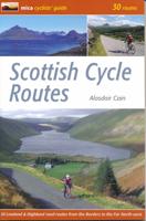
Fietsgids Scottish Cycle Routes | Mica Publishing
Goede beschrijvingen, redelijke kaarten, soms met hoogteprofielen.   In the cyclists' guide series from Mica publishers, here are 30 circular road cycle routes of 35 miles to 115 miles, exploring the best of Scotland's panoramic back roads from the Far North-West to the Borders. The routes include two Cairngorm crossings and the spectacular Bealach na Ba in Applecross, some of the toughest and most spectacular challenges in the country, as well as gentler cross-country and coastal routes round the Black Isle, Moray Coast, Ayrshire, Arran and East Lothian.    These day circuits include detailed descriptions and Ordnance Survey mapping, plus variations and extensions to ensure you get the best from your day. Route profiles indicate uphill and downhill sections and the spread of total height gain. There are also route fact files indicating starting point, distance, height gain, maximum gradient and approximate time. There are extensions & variations to shorten and lengthen routes, plus a…
19,95

Klanten-reviews van Fietskaart Reivers Cycle Routes | Northern Heritage Services

Er zijn nog geen beoordelingen voor dit productBen jij de eerste die een review plaatst?

Meer over Fietskaart Reivers Cycle Routes | Northern Heritage Services

Productomschrijving

The long-distance Reivers Cycle Routes are two intertwining signed / waymarked bi-directional ‘coast to coast’ cycle routes between the North Sea and the Irish Sea.   The original Reivers Cycle Route was created in 1998 eventually becoming NCN Route 10 with interlinking on-road and off-road sections but this soon morphed into a one-size-fits-all route which never worked well. The regenerated re-launched Reivers Cycle Routes are two intertwining route options – one which is as much off-road as possible suitable for gravel and cross bikes, hybrids and mountain bikes and a version designed for capable road cyclists 100% on tarmac.   The routes are bi-directional and continuously reward the rider with beautiful views of the constantly changing terrain, provide many places of interest to pass by or call in and many lovely villages and quiet hamlets to cycle through or stay the night. Most importantly, there is a supply of excellent on route or close-to-route refreshments stops.   The off-road version is waymarked with mulberry coloured waymarks, and the on-road route is signed using standard blue coloured cycle route signs. Some sections may no longer have or have ever been, allocated NCN status and those sections are signed and or waymarked without a red 10.   The Reivers Cycle Routes logo is a lime green coloured roundel detailing two crossed swords being a weapon favoured by the original Reivers. This logo brands the route and appears on all road signs. The same logo but mulberry coloured signifies and characterises the off-road alignment of the Reivers Cycle Route.   En route it is possible to: experience iconic landmarks beginning / ending at Tynemouth with its many historic connections, sandy cove, twin piers, castle and priory; ride through hidden parts of Northumberland rich with heritage; traverse Scandinavian-like Kielder Water and Forest Park; cross the line of Hadrian’s Wall; ride via Carlisle Castle and Tullie House Museum; take in little known corners of Northumberland National Park and enjoy the northern fringe of the Lake District National Park arriving at, or departing from, Maryport harbour on West Cumbria’s World Heritage Site coastline.   Reivers Off-road Adventure Cycle Route   The Reivers Off-road Adventure Route is a new style of waymarked long-distance cycle route which requires a higher level of self-sufficiency than traditional road-based cycle routes. This route is a ‘coast to coast’ journey as off-road as possible encompassing an incredible variety of landscapes in a truly imaginative way by utilising miles of excellent off-road tracks of real quality.   Reivers On-road Challenge Cycle Route   The Reivers On-road Challenge Cycle Route will provide an opportunity for road cyclists to safely and enjoyably cycle a scenic ‘coast to coast’ route which is 100% on-road passing through remote locations. This route version optionally starts/ends at Ponteland although starting/ending at Tynemouth remains an option.   The Reivers Adventure / Challenge Cycle Routes will appeal to a variety of touring cyclists looking for an achievable challenge and an opportunity to safely ride a ‘coast to coast’ route which is either as much off-road as possible or is entirely on-road.   Undoubtedly, both route options truly are challenging journeys of discovery, comprising many miles that are ‘off the beaten track’ waiting to be explored. Do plan to ride your preferred route type across this beautiful and often remote part of Northern England.

Verken gerelateerde categorieën

Webshop.nl maakt gebruik van cookies. Ga je verder op onze website, ga dan akkoord met het plaatsen van cookies en de verwerking van deze data door ons en vermelde partners.