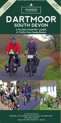
Fietskaart Cycling guides Dartmoor - South Devon | Goldeneye

0
Dartmoor. One of England’s greater National Parks; the Forest of Dartmoor covers 365 square miles and contains the highest ground in England south of the Peak District. On its desolate moorland tracks the wanderer can believe they are further from a public road than anywhere in the country, but on the fringes lush valleys lead down on every side t...

Verkopers met dit product

Verkoper
Bezorging
Prijs
DeZwerver.nl logo
DeZwerver.nl
2,95
12,95

Anderen bekeken ook

Fietskaart Cycling guides Exmoor - North Devon | Goldeneye
Scheur- en watervast foetskaart van Exmoor en Noord Devon met ingetekende fietsroutes.   Our maps are double-sided, printed on an A2 sheet with a concertina fold. This allows for easy folding and folding, and an ease of access to the mapping. The material is rain and tear-resistant. Our early maps were designed at the scale of 2 miles to 1 inch/1:126,720. The later designs along with digitalisation are 1: 100,000. We were encouraged by the Cycle Touring Club to convert our cartography toward the cycle market (to replace the out-of-print Bartholomew series). As time and the series progressed we have added more data: The National Cycle Network routes, Regional Routes, and Traffic-Free Family Routes, as and when they are developed. These routes are in addition to the Circular Routes Goldeneye Commissioned at the outset of our publishing schedule. We are also adding to new editions; bike shops, cycle hire, and tea rooms, along with the tourist attractions already featured. Our plan is to …
12,95
Nieuw
Fietskaart 02 Cycling guides Cotswolds cycling | Goldeneye
Fietskaart van Cotswold met ondermeer 28 ingetekende rondritten en veel toeristische informatie. Explore the Cotswolds by bike with this laminated, waterproof Cotswolds map. With 28 circular, clearly-marked routes this easy-to-use map will help you discover the best of the Cotswolds along the quietest country lanes. The Cotswolds are ideal for the touring cyclist and day-tripper.   They represent England at her very best. Long, winding lanes connect beautiful villages with excellent pubs and friendly tearooms. The landscape you cycle through is rich in imagery; rolling hills, dry-stone walls, lazy trickling trout streams and quaint, undisturbed hamlets.   Our Cotswold Cycling Country Lanes map includes:* Traffic-free family cycling trails - including the Stroud Valley Cycle Trail, The Oxford Waterway and the Forest of Dean Family Trail with recommendations on where to park. * National Cycle Network routes - the linked series of traffic-free paths and traffic-calmed roads being de…
15,95
Fietskaart 10 Cycling guides North York Moors | Goldeneye
Scheur- en watervast foetskaart van de North York Moors  met ingetekende fietsroutes.   Our maps are double-sided, printed on an A2 sheet with a concertina fold. This allows for easy folding and folding, and an ease of access to the mapping. The material is rain and tear-resistant. Our early maps were designed at the scale of 2 miles to 1 inch/1:126,720. The later designs along with digitalisation are 1: 100,000. We were encouraged by the Cycle Touring Club to convert our cartography toward the cycle market (to replace the out-of-print Bartholomew series). As time and the series progressed we have added more data: The National Cycle Network routes, Regional Routes, and Traffic-Free Family Routes, as and when they are developed. These routes are in addition to the Circular Routes Goldeneye Commissioned at the outset of our publishing schedule. We are also adding to new editions; bike shops, cycle hire, and tea rooms, along with the tourist attractions already featured. Our plan is to m…
14,95
Fietskaart 14 Cycling guides Suffolk | Goldeneye
To be confronted with the variety and complexity of the cycling routes, trails and paths in Suffolk can be a bewildering experience.  For it appears that the Suffolk County Council and the three District Councils are all trying hard to promote their areas. This is indeed encouraging for the growth of cycling, but it can be confusing.  Our purpose is to provide clear, easy to use and easy to follow, cycling maps, and to illustrate these in a comprehensive form.    Suffolk must be one of the most charming of counties to explore by bicycle. When Al Churcher delivered his routes to us at Goldeneye we couldn’t keep him quiet, such was his enthusiasm and wonder at Suffolk’s country lanes and byways. He has cycled all over the UK, Canada, Mallorca, New Zealand and Sicily, but Suffolk remained a firm favourite.    The inland scenery is not spectacular for the county’s main glory lies with its attractive villages; the local architecture jealously preserved from modern depredation. There is an …
15,95
Fietskaart 09 Cycling guides Norfolk | Goldeneye
Norfolk is the fourth largest county in England and one of the most rural. It is also one of the flattest and our circular routes have been chosen to explore the quiet lanes linking the isolated and picturesque villages and places of interest. This is ideal cycling territory and fortunately, the Norfolk County Council (and its District Councils) are seriously committed in providing and developing cycling routes and in promoting a cycling culture that is sustainable and family friendly. Some of their routes are illustrated, hitherto.   The County has been described as flat (rather gentle undulations) and does not in fact rise much over 300 feet, but it offers great scenic interest; the dark forests of Breckland, the rolling chalk lands of the northwest, the unique watery patch of the Broads, and a coastline of great variety. Ancient churches and picturesque villages are there in abundance, the latter often decorated with the attractive signs designed by Harry Carter in the 1950’s.   Re…
14,95
Fietskaart 01 Cycling guides Cornwall | Goldeneye
Our maps are double-sided, printed on an A2 sheet with a concertina fold. This allows for easy folding and folding, and an ease of access to the mapping. The material is rain and tear-resistant. Our early maps were designed at the scale of 2 miles to 1 inch/1:126,720. The later designs along with digitalisation are 1: 100,000. We were encouraged by the Cycle Touring Club to convert our cartography toward the cycle market (to replace the out-of-print Bartholomew series). As time and the series progressed we have added more data: The National Cycle Network routes, Regional Routes, and Traffic-Free Family Routes, as and when they are developed. These routes are in addition to the Circular Routes Goldeneye Commissioned at the outset of our publishing schedule. We are also adding to new editions; bike shops, cycle hire, and tea rooms, along with the tourist attractions already featured. Our plan is to make available digital versions for cell phones and tablets and to update, on an annual b…
15,95
Reisgids Slow Travel South Devon - Dartmoor | Bradt Travel Guides
Een bijzondere serie van Bradt guides, waarin een gedeelte van Engeland of Schotland uitgebreid beschreven wordt. Met veel aandacht voor kleine details die je niet al gauw elders zult vinden. Naast de beschrijvende informatie vind je ook een schat aan praktische informatie als accommodatie-adressen of leuke pubs. Een aanrader! This new third edition of South Devon and Dartmoor is part of Bradt's distinctive 'Slow travel' series of guides to UK regions, offering in-depth exploration of one of England's most popular areas. Written by resident experts Hilary Bradt and Janice Booth, it is the essential companion guide to discovering not just the obvious and most popular sites, but also for getting off the beaten track and understanding what makes this gorgeous part of the country tick.  Much of the information in Bradt's South Devon and Dartmoor has appeared in no other guidebook (apart from the first edition of this book) as the authors uncover the lesser-known charms of the region as we…
22,50
Wandelgids Walk! Dartmoor | Discovery Walking Guides
Engelstalige wandelgids voor Dartmoor, met uitgebreide beschrijvingen van wandelroutes, routekaartjes, praktische informatie zoals bussen en accommodatie. Kate and Alan Hobbs have reviewed and refreshed their Walk! Dartmoor classic guide book for its new 2016 edition. 40 fully detailed walking routes with OS maps and gps waypoints for you to enjoy adventuring on Dartmoor. Walk! Dartmoor with Kate and Alan Hobbs covers walks of varying length across Dartmoor - from the dramatic high moors, gentle riversides, idyllic country lanes, unspoilt villages, to sites of ancient archaeology and former industries, and all with spectacular views.   This user friendly illustrated guide has a summary of walking routes and is rated by time, effort, distance and hills, as well as the availability of refreshments en route and the vertigo risk.Each walk is described in full and there are timings listed in the book to help with navigation and progress. Walk! Dartmoor contains a 1:40,000 scale Ordnance Su…
19,95
Fietsgids London - Land's End Cycle Route | EOS Cycling Holidays Ltd
The guidebook contains routes from both Dover and Harwich ferry ports to London. This makes it possible to cycle around the English Channel, when also using the Plymouth link. The Dover to London route takes you though the fruit orchards of Kent, historic Canterbury and the Medway estuary with its impressive castles.   The Harwich to London route provides pleasant countryside cycling in Essex and takes you through Roman Colchester. Cycling through the heart of London, our route manages to stay away from busy roads, the occasional busy junction crossing excepted. Most of the cycling takes place on towpaths along the River Thames with spectacular views to enjoy.   You will cycle under the Tower Bridge and you'll pass the London Eye, Big Ben, the Houses of Parliament and Buckingham Palace on the way. Greenwich Park, Hyde Park and Richmond Park all provide superb green traffic-free routes. Heading west you'll cycle by Windsor Park and Windsor Castle before making your way to the Aon & Ken…
41,50
Fietskaart 02 Cycle Maps UK North and South Devon | Cordee
Een nieuwe fietskaarten serie van Groot-Brittannië. Gedrukt op scheur- en watervast papier en mooi handzaam klein formaat. Deze kaarten zijn met name heel goed om de Lange Afstands Fietsroutes (LF) te fietsen, het National Cycle Network staat duideljk ingetekend. Daarnaast vind je op de kaart veel praktische informatie als fietsenmakers, campings, jeugdherbergen en supermarkt.  Map 2 covers North and South Devon, including Dartmoor and the western part of Exmoor National Parks. The Devon coast to Coast route from Ilfracombe to Plymouth is fully covered.   The maps are all produced at a scale of 1:100 000 showing important features including the National cycle Network. Sections on road, off road and traffic free are all shown in differing colours along with their route number. Other roads and their classification are shown enabling you to link rides or explore sections and discover new routes at home or further afield.   Facilities such as toilets, pubs, accommodation, bike shops, repa…
12,95

Klanten-reviews van Fietskaart Cycling guides Dartmoor - South Devon | Goldeneye

Er zijn nog geen beoordelingen voor dit productBen jij de eerste die een review plaatst?

Meer over Fietskaart Cycling guides Dartmoor - South Devon | Goldeneye

Productomschrijving

Dartmoor. One of England’s greater National Parks; the Forest of Dartmoor covers 365 square miles and contains the highest ground in England south of the Peak District. On its desolate moorland tracks the wanderer can believe they are further from a public road than anywhere in the country, but on the fringes lush valleys lead down on every side to thick woodland, green vegetation and picturesque villages. Dartmoor is well known for its wildlife - attractive herds of ponies, seemingly wild but in fact individually owned, foxes, badgers and otters - also the occasional adder. Fallow, roe and Sitka deer can often be seen, but the red deer of Exmoor have never penetrated the area. Buzzards, kestrels and various Birds of Prey are frequently seen, as well as the wheatear, while crows, ravens and the skylark are fairly commonplace. The Moor abounds in prehistoric remains. There are also many deserted medieval villages with remains of the traditional ‘longhouse’ buildings. For centuries tin mining has been an important activity and there is much to interest the industrial archaeologist, including abandoned tramways and railways of more recent times - notably the Princetown Railway, once the highest railway line in England, now a moderately easy mountain bike track.    The South Hams. Stretching from Plymouth to Salcombe and Start Point, and up the eastern coastline to Dartmouth. This curiously named area, based on the old English name ‘Hamme’ meaning enclosed or sheltered place, is one of rocky coasts and beaches broken up by the tidal estuaries of the Yealm, Erme and Avon, and the lovely stretch of water below Kingsbridge with its quiet creeks delving far inland. High cliffs mostly dominate the coastline, but here and there are attractive little villages of thatched cottages; Wembury, Bigbury, Inner and Outer Hope. Inland is a pastoral landscape of rolling hills and red-earthed fields bisected by twisty roads beneath high hedges.    So, if you seek the peace of quiet country lanes, the beauty of lush river valleys and the heaven sent views across Dartmoor, afforded by flat ridges which soon swoop you down to picturesque villages with tea rooms awash with clotted cream, and hospitable inns. Look no more. It is all here.  Happy Cycling, Al Churcher   Recommended Routes/Trails   National Cycle Network (NCN)   1. Devon Coast to Coast (NCN Route 27) Ilfracombe to Plymouth 164km/102 miles, 51km/32 miles of continuous traffic-free trail from Braunton-Meeth. Joins the Granite Way at Okehampton (see above), and from Lydford follows the western fringes of Dartmoor to Tavistock, and south from there to more traffic-free sections along the superb Drake’s Trail, (see above) leading to Plymouth Ho! (B7)    2. Southern Coastal Route (NCN Route 2) Plymouth to Dorset, and beyond. This is currently being developed and is planned to pass through Totnes, Newton Abbot, and beside the Teign Estuary, Teignmouth, Dawlish, beside the Exe Estuary to Exeter, and on through Sidmouth, Seaton and Axminster.    Regional Routes    a) Plymouth to Totnes 32 km/20 miles. Suitable for commuting and utility cycling. From Plymouth (Deep Lane, A38 flyover), the route parallels the A38 trunk road through Lee Mill, Ivybridge and South Brent. Branching out to Rattery, Dartington and Totnes along quiet lanes. (B7)    b) Totnes (Ashprington) to East Portlemouth. From Ashprington the route follows quiet, country lanes to Blackawton. With some challenging hill sections offering fine views. Passenger ferry carries cycles between East Portlemouth and Salcombe. Follow NCN2 signs all the way. (F7) Traffic-Free Family Routes    Traffic-Free Family Routes/Trails   1. The Granite Way (NCN Route 27) 18km/11 miles. Ideal family cycling between Okehampton and Lydford along former railway with superb views of Dartmoor and the West Devon countryside. Crossing two spectacular viaducts; Meldon and Lake. With short, on-road section via Bridestowe, continuing to Lydford (& Café) along former railway line. (C3)    2. Drake’s Trail. This is a 21-mile cycling and walking route between Plymouth (formerly the Plym Valley Cycle Track to Clearbook) and Tavistock. It is part of the National Cycle Route 27 (Devon Coast-To-Coast). It follows the western edge of Dartmoor beside and through spectacular scenery, passing through tunnels and over bridges. A shared path, ideal for families with pushchairs and dogs, or those in wheelchairs. Marsh Mills and Plymbridge are good start-off points for short excursions. drakes trail.co.uk    3. Totnes – Dartington Riverside Trail (NCN Route 2) 4km/2.5 miles. Easy family trail along path beside the River Dart linking Totnes town centre with the Dartington Cider Press Centre. (F7)    4. Totnes – Ashprington (NCN Route 2) 3.5 km/2 miles. Cycling path along the Dart Estuary overlooking the river and undulating countryside entered along Sharpham Drive to Ashprington. (F7)    5. Exe Cycle Route (NCN Route 2) 7km/4 miles. Easy family trail along the canal linking the centre of Exeter with the head of the Exe estuary. Passes Nature Reserves and Exeter Quay plus new Millers Crossing with link to the rail station, Exeter St David’s. (G3) 

Verken gerelateerde categorieën

Webshop.nl maakt gebruik van cookies. Ga je verder op onze website, ga dan akkoord met het plaatsen van cookies en de verwerking van deze data door ons en vermelde partners.