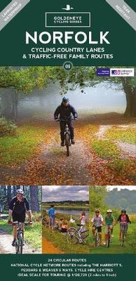
Fietskaart 09 Cycling guides Norfolk | Goldeneye

0
Norfolk is the fourth largest county in England and one of the most rural. It is also one of the flattest and our circular routes have been chosen to explore the quiet lanes linking the isolated and picturesque villages and places of interest. This is ideal cycling territory and fortunately, the Norfolk County Council (and its District Councils) a...

Verkopers met dit product

Webshop
Bezorging
Prijs
DeZwerver.nl logo
DeZwerver.nl
niet bekend
14,95

Anderen bekeken ook

Fietskaart 14 Cycling guides Suffolk | Goldeneye
To be confronted with the variety and complexity of the cycling routes, trails and paths in Suffolk can be a bewildering experience.  For it appears that the Suffolk County Council and the three District Councils are all trying hard to promote their areas. This is indeed encouraging for the growth of cycling, but it can be confusing.  Our purpose is to provide clear, easy to use and easy to follow, cycling maps, and to illustrate these in a comprehensive form.    Suffolk must be one of the most charming of counties to explore by bicycle. When Al Churcher delivered his routes to us at Goldeneye we couldn’t keep him quiet, such was his enthusiasm and wonder at Suffolk’s country lanes and byways. He has cycled all over the UK, Canada, Mallorca, New Zealand and Sicily, but Suffolk remained a firm favourite.    The inland scenery is not spectacular for the county’s main glory lies with its attractive villages; the local architecture jealously preserved from modern depredation. There is an …
15,95
Fietskaart 10 Cycling guides North York Moors | Goldeneye
Scheur- en watervast foetskaart van de North York Moors  met ingetekende fietsroutes.   Our maps are double-sided, printed on an A2 sheet with a concertina fold. This allows for easy folding and folding, and an ease of access to the mapping. The material is rain and tear-resistant. Our early maps were designed at the scale of 2 miles to 1 inch/1:126,720. The later designs along with digitalisation are 1: 100,000. We were encouraged by the Cycle Touring Club to convert our cartography toward the cycle market (to replace the out-of-print Bartholomew series). As time and the series progressed we have added more data: The National Cycle Network routes, Regional Routes, and Traffic-Free Family Routes, as and when they are developed. These routes are in addition to the Circular Routes Goldeneye Commissioned at the outset of our publishing schedule. We are also adding to new editions; bike shops, cycle hire, and tea rooms, along with the tourist attractions already featured. Our plan is to m…
14,95
Fietskaart 01 Cycling guides Cornwall | Goldeneye
Our maps are double-sided, printed on an A2 sheet with a concertina fold. This allows for easy folding and folding, and an ease of access to the mapping. The material is rain and tear-resistant. Our early maps were designed at the scale of 2 miles to 1 inch/1:126,720. The later designs along with digitalisation are 1: 100,000. We were encouraged by the Cycle Touring Club to convert our cartography toward the cycle market (to replace the out-of-print Bartholomew series). As time and the series progressed we have added more data: The National Cycle Network routes, Regional Routes, and Traffic-Free Family Routes, as and when they are developed. These routes are in addition to the Circular Routes Goldeneye Commissioned at the outset of our publishing schedule. We are also adding to new editions; bike shops, cycle hire, and tea rooms, along with the tourist attractions already featured. Our plan is to make available digital versions for cell phones and tablets and to update, on an annual b…
15,95
Fietskaart Cycling guides Exmoor - North Devon | Goldeneye
Scheur- en watervast foetskaart van Exmoor en Noord Devon met ingetekende fietsroutes.   Our maps are double-sided, printed on an A2 sheet with a concertina fold. This allows for easy folding and folding, and an ease of access to the mapping. The material is rain and tear-resistant. Our early maps were designed at the scale of 2 miles to 1 inch/1:126,720. The later designs along with digitalisation are 1: 100,000. We were encouraged by the Cycle Touring Club to convert our cartography toward the cycle market (to replace the out-of-print Bartholomew series). As time and the series progressed we have added more data: The National Cycle Network routes, Regional Routes, and Traffic-Free Family Routes, as and when they are developed. These routes are in addition to the Circular Routes Goldeneye Commissioned at the outset of our publishing schedule. We are also adding to new editions; bike shops, cycle hire, and tea rooms, along with the tourist attractions already featured. Our plan is to …
12,95
Fietsgids Cycling East Anglia | Bradt Travel Guides
Following the same format as Bradt's Cycling in Cornwall & the Isles of Scilly, this new cycling guide to East Anglia offers 21 routes for beginners and 'leisure cyclists', covering Norfolk, Suffolk and Cambridgeshire. Each ride includes comprehensive directions, as well as background features on local history, wildlife and culture. All are linked to OS Explorer maps and relevant National Cycle Network routes (NCN), and include National Grid Reference (NGR) coordinates. In addition, each route has been mapped on route planning and navigation app komoot, where readers can find detailed route insights including an elevation profile and waytype and surface information. Using the komoot app for iOS or Android, readers can also use their smartphones to navigate each route.East Anglia, the snail-like bulge protruding off the back of the United Kingdom's east coast, is a vast flatland of broads, fens and marshes, stretched out under a wide sky. Despite its proximity to London and the Midland…
18,50
Wandelgids Norfolk Coast Path - Peddars Way | Trailblazer Guides
The Norfolk Coast Path & Peddars Way cover 130-miles of walking trails. The Peddars Way runs through East Anglia from Knettishall Heath on the Norfolk/Suffolk border and follows a Roman road to Holme-next-the-Sea. From here it becomes the Norfolk Coast Path, hugging the beautiful Norfolk coastline through Holkham, Wells, Blakeney and Cley to Cromer before it rounds the shoulder of the county and continues along the superb beaches and crumbling cliffs to Mundesley, Sea Palling and Great Yarmouth, finishing just before the Suffolk border.   Includes: 77 large-scale walking maps - at just under 1: 20,000 (8cm or 3 and one eighth inches to 1 mile) our maps are bigger than even the most detailed walking maps currently available, with walking directions, tricky junctions, places to stay and eat, points of interest and walking times written onto the maps Text and maps in clear TWO-COLOUR style All standards of accommodation with reviews - campsites, B&Bs, hostels, hotels, bunkhouses Where to…
20,95
Fietsgids London - Land's End Cycle Route | EOS Cycling Holidays Ltd
The guidebook contains routes from both Dover and Harwich ferry ports to London. This makes it possible to cycle around the English Channel, when also using the Plymouth link. The Dover to London route takes you though the fruit orchards of Kent, historic Canterbury and the Medway estuary with its impressive castles.   The Harwich to London route provides pleasant countryside cycling in Essex and takes you through Roman Colchester. Cycling through the heart of London, our route manages to stay away from busy roads, the occasional busy junction crossing excepted. Most of the cycling takes place on towpaths along the River Thames with spectacular views to enjoy.   You will cycle under the Tower Bridge and you'll pass the London Eye, Big Ben, the Houses of Parliament and Buckingham Palace on the way. Greenwich Park, Hyde Park and Richmond Park all provide superb green traffic-free routes. Heading west you'll cycle by Windsor Park and Windsor Castle before making your way to the Aon & Ken…
41,50
Fietskaart Reivers Cycle Routes | Northern Heritage Services
The long-distance Reivers Cycle Routes are two intertwining signed / waymarked bi-directional ‘coast to coast’ cycle routes between the North Sea and the Irish Sea.   The original Reivers Cycle Route was created in 1998 eventually becoming NCN Route 10 with interlinking on-road and off-road sections but this soon morphed into a one-size-fits-all route which never worked well. The regenerated re-launched Reivers Cycle Routes are two intertwining route options – one which is as much off-road as possible suitable for gravel and cross bikes, hybrids and mountain bikes and a version designed for capable road cyclists 100% on tarmac.   The routes are bi-directional and continuously reward the rider with beautiful views of the constantly changing terrain, provide many places of interest to pass by or call in and many lovely villages and quiet hamlets to cycle through or stay the night. Most importantly, there is a supply of excellent on route or close-to-route refreshments stops.   The off-r…
16,50
Wandelkaart National Trail Map Peddars Way and Norfolk Coast | Collins
Overzichtskaart op vrij grove schaal van deze LAW Lange Afstands Wandeling in Engeland. Let op: je kunt er niet op lopen. Wel met veel informatie op de kaart, goed ingetekend, een route-schema op de achterzijde en een beschrijving van een aantal bezienswaardigheden.  Perfect guide and map for planning your adventure along Peddar’s Way and the Norfolk Coast Path. This incorporates part of the newly formed England Coast Path.   Highlights of this Planning Map include:   More than 20 highlighted places of interest with detailed descriptions and attractive photographs, including: the Hunstanton striped cliffs, Blakeney Point, and Binham Priory A comprehensive index to more than 600 cities, towns and villages A clear, visible route plotted across a 2.4 miles to 1 inch (1.5 km to 1 cm) scale map Advice on safety and security when travelling along the route, as well as the countryside code and the code of conduct Part of the National Trail network, these two long-distance footpaths cover 93 …
11,50
Fietskaart 08 Cycling guides Lake District | Goldeneye
Scheur- en watervast foetskaart van het Lake District met ingetekende fietsroutes. Our maps are double-sided, printed on an A2 sheet with a concertina fold. This allows for easy folding and folding, and an ease of access to the mapping. The material is rain and tear-resistant. Our early maps were designed at the scale of 2 miles to 1 inch/1:126,720. The later designs along with digitalisation are 1: 100,000. We were encouraged by the Cycle Touring Club to convert our cartography toward the cycle market (to replace the out-of-print Bartholomew series). As time and the series progressed we have added more data: The National Cycle Network routes, Regional Routes, and Traffic-Free Family Routes, as and when they are developed. These routes are in addition to the Circular Routes Goldeneye Commissioned at the outset of our publishing schedule. We are also adding to new editions; bike shops, cycle hire, and tea rooms, along with the tourist attractions already featured. Our plan is to make a…
12,95

Klanten-reviews van Fietskaart 09 Cycling guides Norfolk | Goldeneye

Er zijn nog geen beoordelingen voor dit productBen jij de eerste die een review plaatst?

Meer over Fietskaart 09 Cycling guides Norfolk | Goldeneye

Productomschrijving

Norfolk is the fourth largest county in England and one of the most rural. It is also one of the flattest and our circular routes have been chosen to explore the quiet lanes linking the isolated and picturesque villages and places of interest. This is ideal cycling territory and fortunately, the Norfolk County Council (and its District Councils) are seriously committed in providing and developing cycling routes and in promoting a cycling culture that is sustainable and family friendly. Some of their routes are illustrated, hitherto.   The County has been described as flat (rather gentle undulations) and does not in fact rise much over 300 feet, but it offers great scenic interest; the dark forests of Breckland, the rolling chalk lands of the northwest, the unique watery patch of the Broads, and a coastline of great variety. Ancient churches and picturesque villages are there in abundance, the latter often decorated with the attractive signs designed by Harry Carter in the 1950’s.   Recommended Routes/Trails   National Cycle Network (NCN) & Regional Routes   This is a linked series of traffic-free paths and traffic-calmed roads being developed across the UK linking town centres and the countryside.  The so-named route numbers do not always join up as the overall planned route has not been completed and sometimes they overlap with other routes. www.sustrans.org.uk    The following NCN routes cross Norfolk:-   NCN Route 1.    Hull to Harwich. A 370 mile route passing Cathedral cities, towns and villages through pastoral countryside. Connects Norwich to Fakenham and King’s Lynn. Mainly on road but does use the Marriott’s Way. Links with Norfolk Coast Cycleway at Wighton (E1) and with NCN 13 at Gateley (F4).   NCN Routes 13.    Dereham to Thetford. A 30 mile route passes through the distinctive Breckland landscape of mid-Norfolk. Follows minor roads joining the Peddars Way between Wretham (E9) and Pockthorpe (E8). Route through Dereham has been resurfaced and improvements north of Thetford are planned, as is a route south from Thetford.    Regional Routes   1. Norfolk Coast Cycleway NCN 30. A fine route running inland away from the busy coast road. It affords spectacular views; dramatic scenery, endless skies and much birdlife. Originally 59 miles from Cromer to King’s Lynn, now with 39 mile extension to Great Yarmouth. Careful between Sea Palling and Great Yarmouth but be prepared to take alternative route walking beside the River Thurne between Potter Heigham and Martham.   2. Regional Route 30. Norfolk/Suffolk border from Thetford to Beccles and Lowestoft, and Downham Market.   Traffic-Free Family Routes   1. Bacton Wood. Circular rides up to 2 miles within 133 hectares. Picnics. Linked to North Coast Cycleway. Hybrid/Mountain bike required. (L3)   2. Bure Valley Railway & Path. 9-mile route between Aylsham and Wroxham with return journey by miniature steam train. (J3-L5)   3. Holkham Hall. Circular route from Wells passes through the grounds. (E1)   4. Hockwold. See our Route No. 12 below. (B9)   5. Marriott’s Way. 26-mile route using the trackbeds of two disused railways named after local railway engineer, William Marriott. Links Aylsham and Reepham with Norwich, and is open to cyclists, walkers and horse riders. Often remote hence an abundance of wildlife, flowers and plants. (H4-5, J4-5)    6. Paston Way. Short one-mile route allowed for cyclists from North Walsham to Knapton. Walkers may continue for further 7 miles. (L3)   7. Peddars Way. A challenging 46-mile route, the origin whose name is obscure, links Knettishall Heath near Thetford with the coast at Holme. For the most part it follows the old Roman road built to restrain the rebellious Iceni tribe. Open to cyclists, walkers and horse riders. (F10-B1)   8. Quiet Lanes Project. See our route no.17. (L2)   9. Thetford Forest. Wide scope of off-road riding with links to Peddars Way. Bike hire at Forest High Lodge. (D9)   10. Weaver’s Way. 56-mile trail linking Cromer with Great Yarmouth by a circuitous route designed to cover a variety of scenery and places of interest using minor roads, footpaths and old railway lines. Named after weaving trade. Cycling only permitted on 13-mile section between Aylsham and Stalham. Surface often pitted. Short section of road through market town of North Walsham. (K3)

Verken gerelateerde categorieën

Webshop.nl maakt gebruik van cookies. Ga je verder op onze website, ga dan akkoord met het plaatsen van cookies en de verwerking van deze data door ons en vermelde partners.