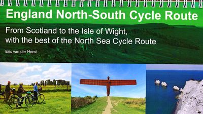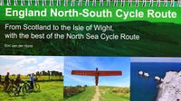
Fietsgids England North - South Cycle Route | EOS Cycling Holidays Ltd

0
This guidebook allows you to cycle from the Scottish border across England to the Isle of Wight, all via continuous traffic-calmed routes. The book also features the best of the North Sea Cycle Route and offers full north-south route directions, high-profile maps, visitor information, accommodation listings and a code to obtain GPS-tracks of the r...

Verkopers met dit product

Webshop
Bezorging
Prijs
DeZwerver.nl logo
DeZwerver.nl
niet bekend
29,95

Anderen bekeken ook

Fietsgids London - Land's End Cycle Route | EOS Cycling Holidays Ltd
The guidebook contains routes from both Dover and Harwich ferry ports to London. This makes it possible to cycle around the English Channel, when also using the Plymouth link. The Dover to London route takes you though the fruit orchards of Kent, historic Canterbury and the Medway estuary with its impressive castles.   The Harwich to London route provides pleasant countryside cycling in Essex and takes you through Roman Colchester. Cycling through the heart of London, our route manages to stay away from busy roads, the occasional busy junction crossing excepted. Most of the cycling takes place on towpaths along the River Thames with spectacular views to enjoy.   You will cycle under the Tower Bridge and you'll pass the London Eye, Big Ben, the Houses of Parliament and Buckingham Palace on the way. Greenwich Park, Hyde Park and Richmond Park all provide superb green traffic-free routes. Heading west you'll cycle by Windsor Park and Windsor Castle before making your way to the Aon & Ken…
41,50
Fietskaart 10 Cycling guides North York Moors | Goldeneye
Scheur- en watervast foetskaart van de North York Moors  met ingetekende fietsroutes.   Our maps are double-sided, printed on an A2 sheet with a concertina fold. This allows for easy folding and folding, and an ease of access to the mapping. The material is rain and tear-resistant. Our early maps were designed at the scale of 2 miles to 1 inch/1:126,720. The later designs along with digitalisation are 1: 100,000. We were encouraged by the Cycle Touring Club to convert our cartography toward the cycle market (to replace the out-of-print Bartholomew series). As time and the series progressed we have added more data: The National Cycle Network routes, Regional Routes, and Traffic-Free Family Routes, as and when they are developed. These routes are in addition to the Circular Routes Goldeneye Commissioned at the outset of our publishing schedule. We are also adding to new editions; bike shops, cycle hire, and tea rooms, along with the tourist attractions already featured. Our plan is to m…
14,95
Fietskaart 14 Cycling guides Suffolk | Goldeneye
To be confronted with the variety and complexity of the cycling routes, trails and paths in Suffolk can be a bewildering experience.  For it appears that the Suffolk County Council and the three District Councils are all trying hard to promote their areas. This is indeed encouraging for the growth of cycling, but it can be confusing.  Our purpose is to provide clear, easy to use and easy to follow, cycling maps, and to illustrate these in a comprehensive form.    Suffolk must be one of the most charming of counties to explore by bicycle. When Al Churcher delivered his routes to us at Goldeneye we couldn’t keep him quiet, such was his enthusiasm and wonder at Suffolk’s country lanes and byways. He has cycled all over the UK, Canada, Mallorca, New Zealand and Sicily, but Suffolk remained a firm favourite.    The inland scenery is not spectacular for the county’s main glory lies with its attractive villages; the local architecture jealously preserved from modern depredation. There is an …
15,95
Opruiming - Fietsgids Cycling in Amsterdam and the Netherlands | EOS Cycling Holidays Ltd
OUDE DRUK   There is no happier cyclist than a Dutch cyclist. This is not only because The Netherlands is mainly flat, but also because the Dutch enjoy the most extensive cycle network in the world. With our guidebook, we present you the very best routes in the cyclist’s paradise!   Amsterdam is famous for its cyclists and with our guidebook you’ll cycle on those routes the locals love themselves. Whether you are a novice cyclist, want to give children a safe and fun cycling experience, want to do some serious mileage or want to embark on a study trip to experience the Dutch cycling infrastructure, our second and fully revised edition of our book caters for all!   Our book Cycling in Amsterdam and The Netherlands – The very best routes in the cyclist’s paradise features 1,064 kms (656 miles) of routes, so you can truly have up to three weeks of cycling fun; the perfect companion for one or multiple excellent cycling holidays!   The routes in the book have full connectivity with all…
8,95
Fietskaart Cycling guides Exmoor - North Devon | Goldeneye
Scheur- en watervast foetskaart van Exmoor en Noord Devon met ingetekende fietsroutes.   Our maps are double-sided, printed on an A2 sheet with a concertina fold. This allows for easy folding and folding, and an ease of access to the mapping. The material is rain and tear-resistant. Our early maps were designed at the scale of 2 miles to 1 inch/1:126,720. The later designs along with digitalisation are 1: 100,000. We were encouraged by the Cycle Touring Club to convert our cartography toward the cycle market (to replace the out-of-print Bartholomew series). As time and the series progressed we have added more data: The National Cycle Network routes, Regional Routes, and Traffic-Free Family Routes, as and when they are developed. These routes are in addition to the Circular Routes Goldeneye Commissioned at the outset of our publishing schedule. We are also adding to new editions; bike shops, cycle hire, and tea rooms, along with the tourist attractions already featured. Our plan is to …
12,95
Fietskaart Cycle Map Pennine Cycleway South | Sustrans
The official route map for the 136-mile (219km) southern part of the Pennine Cycleway on National Cycle Network Route 68 from Derby to Settle.   This linear map shows the route and immediate surrounding area over a series of separate map panels. The full colour map based on Ordnance Survey data shows clearly mapped cycle routes on traffic-free paths, quiet lanes and roads, with easy to read contours, route profiles and mile markers. Also features detailed inset maps for the major towns and cities, tourist info and cycle shop and hire information, and other local routes.   The southern half of the Pennine Cycleway is a beautiful, yet challenging ride which takes you through the dramatic scenery of the Peak District and the South Pennines. The route takes you from the bustling railway city of Derby to the historic town of Settle, taking in the famous spa town of Buxton and the lovely Yorkshire town of Holmfirth, renowned location of the TV classic “Last of the Summer Wine”.   This secti…
13,50
Fietsgids Cycling Scotland's North Coast | Crowood
Beschrijving van de route is zeer gedetailleerd, kaartmateriaal is minder, het zijn slechts schetsen. This cycling guidebook follows the course of a new cycling route around the North Coast of Scotland, described as Scotland's own Route 66. Since its launch in 2015 this route--branded as"'North Coast 500" (NC500)--has proved to be a resounding success, with motorists, motorcyclists, and cyclists flocking to Inverness to put rubber to the road, driving and riding through some of the most spectacular scenery in the United Kingdom. This guidebook is aimed specifically at cyclists, describing the entire coastal route over seven stages. A sketch plan, elevation graphs, and turn-by-turn directions are given to each stage; points of interest are highlighted, and in many cases illustrated; helpful sections on travel to Inverness, nutrition, navigation, and emergency cycle repairs; alternative route is offered to the busy and challenging A9 section south of Wick; and finally, a full list of ac…
16,50
Fietskaart 01 Cycling guides Cornwall | Goldeneye
Our maps are double-sided, printed on an A2 sheet with a concertina fold. This allows for easy folding and folding, and an ease of access to the mapping. The material is rain and tear-resistant. Our early maps were designed at the scale of 2 miles to 1 inch/1:126,720. The later designs along with digitalisation are 1: 100,000. We were encouraged by the Cycle Touring Club to convert our cartography toward the cycle market (to replace the out-of-print Bartholomew series). As time and the series progressed we have added more data: The National Cycle Network routes, Regional Routes, and Traffic-Free Family Routes, as and when they are developed. These routes are in addition to the Circular Routes Goldeneye Commissioned at the outset of our publishing schedule. We are also adding to new editions; bike shops, cycle hire, and tea rooms, along with the tourist attractions already featured. Our plan is to make available digital versions for cell phones and tablets and to update, on an annual b…
15,95
Fietskaart 09 Cycling guides Norfolk | Goldeneye
Norfolk is the fourth largest county in England and one of the most rural. It is also one of the flattest and our circular routes have been chosen to explore the quiet lanes linking the isolated and picturesque villages and places of interest. This is ideal cycling territory and fortunately, the Norfolk County Council (and its District Councils) are seriously committed in providing and developing cycling routes and in promoting a cycling culture that is sustainable and family friendly. Some of their routes are illustrated, hitherto.   The County has been described as flat (rather gentle undulations) and does not in fact rise much over 300 feet, but it offers great scenic interest; the dark forests of Breckland, the rolling chalk lands of the northwest, the unique watery patch of the Broads, and a coastline of great variety. Ancient churches and picturesque villages are there in abundance, the latter often decorated with the attractive signs designed by Harry Carter in the 1950’s.   Re…
14,95
Fietskaart 02 Cycle Maps UK North and South Devon | Cordee
Een nieuwe fietskaarten serie van Groot-Brittannië. Gedrukt op scheur- en watervast papier en mooi handzaam klein formaat. Deze kaarten zijn met name heel goed om de Lange Afstands Fietsroutes (LF) te fietsen, het National Cycle Network staat duideljk ingetekend. Daarnaast vind je op de kaart veel praktische informatie als fietsenmakers, campings, jeugdherbergen en supermarkt.  Map 2 covers North and South Devon, including Dartmoor and the western part of Exmoor National Parks. The Devon coast to Coast route from Ilfracombe to Plymouth is fully covered.   The maps are all produced at a scale of 1:100 000 showing important features including the National cycle Network. Sections on road, off road and traffic free are all shown in differing colours along with their route number. Other roads and their classification are shown enabling you to link rides or explore sections and discover new routes at home or further afield.   Facilities such as toilets, pubs, accommodation, bike shops, repa…
12,95

Klanten-reviews van Fietsgids England North - South Cycle Route | EOS Cycling Holidays Ltd

Er zijn nog geen beoordelingen voor dit productBen jij de eerste die een review plaatst?

Meer over Fietsgids England North - South Cycle Route | EOS Cycling Holidays Ltd

Productomschrijving

This guidebook allows you to cycle from the Scottish border across England to the Isle of Wight, all via continuous traffic-calmed routes. The book also features the best of the North Sea Cycle Route and offers full north-south route directions, high-profile maps, visitor information, accommodation listings and a code to obtain GPS-tracks of the routes. The route has full connectivity with Newcastle, Hull and Portsmouth international ferry ports and train stations in Berwick upon Tweed, Newcastle, Hull, York, Leicester, Oxford and Portsmouth. The total route is over 750 miles (1200 kilometers) long.   Starting from the north in Berwick upon Tweed, the route takes touring cyclists via Lindisfarne Holy Island and five historic remote Northumberland castles. In Newcastle you can cycle via the famous Angel of the North to remains of Hadrian's Wall. The route heads south via World Heritage site Durham and the extraordinary River Tees Transporter Bridge into North York Moors National Park. Between Whitby and Scarborough you'll cycle the Cinder Track, the very best of the North Sea Cycle Route. Multiple routes connect to Hull and world-class York.   The Pennines Trail and Don Valley Trail take you to Peak District National Park. The Monsal and Tissington Trails will take you across the Pennines via the pretty Derbyshire Dales and Burton on Trent to Leicester. Via Rugby, Royal Leamington Spa, Warwick Castle and Shakespeare's Stratford-upon-Avon you'll arrive in the Cotswolds. Via downtown Oxford you travel via Uffington White Horse, Avebury and Stonehenge to Salisbury. The New Forest National Park and Isle of Wight bring you at the cliffs of The Needles; an ultimate 'end of the land'-finale of the ride.

Verken gerelateerde categorieën

Webshop.nl maakt gebruik van cookies. Ga je verder op onze website, ga dan akkoord met het plaatsen van cookies en de verwerking van deze data door ons en vermelde partners.