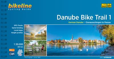
Fietsgids Bikeline Danube Bike Trail 1 (Engels - Donau Radweg) | Esterbauer

0
Praktische fietsgids met detailkaarten, ingetekende route, informatie over overnachten en fietsenmakers, zwaarte en hoogteprofiel. In spiraalbinding, Engelstalig.   Length The Danube cycling route between Donaueschingen and Passau is about 595 kilometers in length, not including alternative routes and excursions.   Surface quality and traffic Most...

Verkopers met dit product

Webshop
Bezorging
Prijs
DeZwerver.nl logo
DeZwerver.nl
2,95
16,50

Anderen bekeken ook

Nieuw
Fietsgids Moesel - The Moselle Cycle Route | Cicerone
This guidebook covers the entirety of the Moselle river’s course, from its source in the Vosges Mountains of eastern France to its confluence with the Rhine at the west German city of Koblenz. The well-waymarked route reaches historic Nancy and Metz, crosses into Luxembourg and continues through the spectacular Mosel gorge, where the river cuts a sinuous path between the Hunsrück and Eifel Mountains.   The great attraction to a cyclist of following a river from its source is that, once you have reached the start, it's all downhill. From the easily reached source near the Col de Bussang, the Moselle cycle route descends over 650m to the Rhine at Koblenz. At Koblenz, the route can be linked with The Rhine Cycle Route.   In addition to the main route, excursions are described to visit Toul on the Boucles de Moselle, Luxembourg Ville in the Duchy of Luxembourg and through the Saar and Rhine gorges.   Accommodation and places to eat and drink en route are plentiful. Mostly off-road and on …
20,95
Fietsgids Bikeline Mur-radweg | Esterbauer
Praktische fietsgids met detailkaarten, ingetekende route, informatie over overnachten en fietsenmakers, zwaarte en hoogteprofiel. In spiraalbinding, Duitstalig. Van de bron naar Bad Radkersburg, lengte 470 km. Der knapp 470 Kilometer lange Radwanderweg entlang der Mur zählt zu den bekanntesten Radtouren im Alpenraum und hat sich weit über die Grenzen von Österreich hinaus einen Namen gemacht. Die Tour beginnt am Mur-Ursprung in der Nationalparkgemeinde Muhr im schönen salzburgischen Lungau. Doch bald schon erobert der Gebirgsfluss die Steiermark und begleitet nun die Steirische Holzstraße, was sich ganz offensichtlich in der waldreichen Umgebung widerspiegelt. Historische Städte und Burgen säumen den Weg entlang des Murufers ebenso wie Zeugen des Industriezeitalters in den Zentren der steirischen Eisenverarbeitung oder das aufregende Dröhnen der Motoren am Red-Bull-Ring bei Zeltweg. Hinter Bruck an der Mur verändert der Flusslauf seine Richtung und strebt nun inmitten eines engen Tal…
16,50
Fietskaart Reivers Cycle Routes | Northern Heritage Services
The long-distance Reivers Cycle Routes are two intertwining signed / waymarked bi-directional ‘coast to coast’ cycle routes between the North Sea and the Irish Sea.   The original Reivers Cycle Route was created in 1998 eventually becoming NCN Route 10 with interlinking on-road and off-road sections but this soon morphed into a one-size-fits-all route which never worked well. The regenerated re-launched Reivers Cycle Routes are two intertwining route options – one which is as much off-road as possible suitable for gravel and cross bikes, hybrids and mountain bikes and a version designed for capable road cyclists 100% on tarmac.   The routes are bi-directional and continuously reward the rider with beautiful views of the constantly changing terrain, provide many places of interest to pass by or call in and many lovely villages and quiet hamlets to cycle through or stay the night. Most importantly, there is a supply of excellent on route or close-to-route refreshments stops.   The off-r…
16,50
Nieuw
Wandelgids - Fietsgids Hiking and Cycling in the Black Forest | Cicerone
Guidebook describing day walks, multi-stage treks and 5 cycle routes covering the north, central and southern regions of Germany's Black Forest. From easy routes for families to multi-day journeys, the walks and rides explore the many forests, villages, castles and hills near Strasbourg, Baden-Baden, Freiburg and Basle.   Seasons spring and autumn are the best times of the year to visit the Black Forest. But the cool forest glades and lofty hills make summer walking bearable. Some routes are even accessible in winter and make for magical winter wonderland walking   Centres Freiburg im Breisgau Waldkirch, Hinterzarten, Baden Baden, Baiersbronn, Titisee, Bad Wildbad, Nagold, Calw, Breisach am Rhein   Difficulty The Black Forest is a medium-height mountain range with the highest peaks around 1500m. Trails are well marked and maintained, so the terrain is not especially difficult in most parts. Good physical condition and ability to cope with sometimes steep ascends is required. Normal wa…
23,95
Fietskaart 01 Cycling guides Cornwall | Goldeneye
Our maps are double-sided, printed on an A2 sheet with a concertina fold. This allows for easy folding and folding, and an ease of access to the mapping. The material is rain and tear-resistant. Our early maps were designed at the scale of 2 miles to 1 inch/1:126,720. The later designs along with digitalisation are 1: 100,000. We were encouraged by the Cycle Touring Club to convert our cartography toward the cycle market (to replace the out-of-print Bartholomew series). As time and the series progressed we have added more data: The National Cycle Network routes, Regional Routes, and Traffic-Free Family Routes, as and when they are developed. These routes are in addition to the Circular Routes Goldeneye Commissioned at the outset of our publishing schedule. We are also adding to new editions; bike shops, cycle hire, and tea rooms, along with the tourist attractions already featured. Our plan is to make available digital versions for cell phones and tablets and to update, on an annual b…
15,95
Wandelgids Walk! La Gomera | Discovery Walking Guides
La Gomera is the ultimate get-away-from-it-all island: easy-going, unspoilt, friendly, isolated from the hustle and bustle of modern living, and so laid back it’s virtually supine - even the volcanoes have been dormant for millions of years. The walks, however, are a bit more energetic. For the new 4th edition of Walk! La Gomera Charles Davis has teamed up with Jan Kostura. Jan brings his wide experience and passion for the Canaries, checking, re-walking and revising existing routes, and adding a couple of his own adventures, including a new Top Three Gomeran walk. Two routes have been dropped as having become too dangerous, but the good news is that many of the more harum-scarum walks have been improved through path clearing and the addition of railings to the vertiginous stretches. Other good news is that the devastating forest fires of 2012 have proved not nearly as damaging as we feared, leaving most of our itineraries unscathed. In short, there is every reason to take off and ex…
17,50
Reisgids The World's Great River Journeys | John Beaufoy
Journeying by river provides the perfect opportunity to discover new places or see a new side of a familiar destination. Presented here are 50 remarkable and memorable trips chosen because of the stunning scenery they pass through as well as the historic and cultural sites that can be visited from side excursions. Some cover lengthy trips such as a cruise on the Danube that passes through ten countries from its source before emptying into the Black Sea; others are shorter but have a strong, unifying theme, such as Portugal’s Douro River that was built on viticulture. In Southeast Asia, the leisurely pace of a river trip along the Yangtze, Mekong or Ayeryawaddy Rivers allows time to take in the ancient cultures and exotic landscapes. Beautiful countryside, wine-rich valleys and dramatic gorges are the highlights of a river journey; the scenery is constant and ever changing. But as well as the natural wonders, there are also remarkable man-made engineering feats to experience as you pas…
34,95
Fietsgids Bikepacking in the Lake District | Cicerone
Bikepacking is the off-road equivalent of cycle touring, often offering opportunities for wild camping in addition to the usual accommodation options for sleeping under a roof: it promises an unparalleled opportunity to immerse yourself in the environment as you explore the best of what the area has to offer on two wheels. This guide presents eight challenging 2-5 day rides in the Lake District, suitable for mountain bikes (some routes are also rideable on a gravel bike). All routes are accessible by public transport and many can be completed over a long weekend. They are graded from Moderate to Very Hard, although all involve considerable ascent and descent and sections where you may need to push or carry your bike - as such, they are suited to fit experienced riders. Clear route description, mapping and elevation profiles are supplemented with a wealth of planning information, including accommodation listings, notes on facilities, and summary details (including grades) for each indi…
23,95
Fietsgids The Ultimate Trans Pennine Trail Guide | Excellent Books
Gidsboek voor de Trans Pennine Trail met spiraalbinding, inclusief kaarten, hoogtegrafieken en verblijfsmogelijkheden. The Trans Pennine Trail guide book covers the hugely popular 370 miles (595km) of trail across the north of England is a big favourite with walkers and cyclists, with many sections available for horse-riders and wheelchair users.   The trail is suitable for users of all ages and abilities due to its easy gradients and traffic free conditions. This guide is packed with full colour maps, trail info and photos, making it perfect for planning and use along the way.   Plan a scenic walk or bike ride, perhaps through the Pennines themselves, with its many pretty villages, museums and other visitor attractions along the way, very often with the possibility of a train return.   For weekend or longer breaks on the trail you can select something from the wide range of accommodation in the guide, from the simple to the stylish and the quirky to the budget.   Or, plan your l…
13,95
Reisgids Shetland Guide Book | Charles Tait
The Shetland Guide Book offers unrivalled detail on the more than 100 islands that make up the Shetland Isles. The islands have a wealth of archaeological history, from viking farms to bronze age burial mounds, but the natural wonders are just as impressive and this guide will tell you where you can catch a glimpse of everything from puffins to ponies.   Charles Tait Guidebooks   Charles Tait Guidebooks are photographed, researched, designed and written by the author. Being an Orcadian photographer and travel writer, Charles Tait has been publishing guidebooks based on the natural and cultural history of the Highlands and Islands since 1991. The aim is to create authoritative, readable, informative, easily assimilated handbooks to each area. Each book is extensively illustrated with photographs by Charles Tait, as well as Ordnance Survey maps, old photographs and prints. The guides include introductions covering natural history, archaeology, history and the economy. The Gazetteer cove…
24,95

Klanten-reviews van Fietsgids Bikeline Danube Bike Trail 1 (Engels - Donau Radweg) | Esterbauer

Er zijn nog geen beoordelingen voor dit productBen jij de eerste die een review plaatst?

Meer over Fietsgids Bikeline Danube Bike Trail 1 (Engels - Donau Radweg) | Esterbauer

Productomschrijving

Praktische fietsgids met detailkaarten, ingetekende route, informatie over overnachten en fietsenmakers, zwaarte en hoogteprofiel. In spiraalbinding, Engelstalig.   Length The Danube cycling route between Donaueschingen and Passau is about 595 kilometers in length, not including alternative routes and excursions.   Surface quality and traffic Most of the route follows quiet country lanes or dedicated cycling paths. Sections with heavier traffic are rare and usually short. With only a few exceptions, the roads and paths have a hard surface. Gravel sections are usually in good condition. Because the route follows the course of the river, it is almost completely flat. It is mostly on the excursions into the surrounding countryside that must expect some steep sections. It is possible that during flooding part of the route is unusable or closed and you need to use alternative routes.   Signage Route markers along the Danube bicycle route are generally reliable and good. Signs are located by every change in direction at forks and intersections. From Donaueschingen to Neustadt the signs are yellow with green lettering. Downstream from Neustadt the signs are white with green lettering. After Kelheim the signs also bear the slogan “Tour de Baroque” and the German Danube icon alternates with the lute-player seen on the Tour de Baroque signs.
Webshop.nl maakt gebruik van cookies. Ga je verder op onze website, ga dan akkoord met het plaatsen van cookies en de verwerking van deze data door ons en vermelde partners.