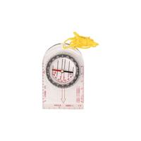
COMPASS SOFTEE SOUTH

0
Perfect visibility due to its height of the numbers on the blue base. It counts with a lace to ease its transportation and 360º rotation capsule. Two scales: 1:10000, 1:15000. Measures: 9x6,5cm. Weight: 40grs....

Verkopers met dit product

Verkoper
Bezorging
Prijs
echtveelvoorweinig.nl logo
echtveelvoorweinig.nl
2-3 werkdagen
6,99
2,08

Anderen bekeken ook

Wandelkaart Tour & Trail Mallorca - Tramuntana South | Discovery Walking Guides
For your best adventures, use the best map. Water-proof, split-proof, tear-proof, adventure-proof. Mallorca's Tramuntana South Tour & Trail Super-Durable Map is simply the toughest, most accurate, easy-to-read, easy-to-use multi-purpose map that you can get.   Whether you plan to walk, or explore southern Tramuntana by car or the bus, this is the map for you. A large 960mm by 694mm double sided map sheet covers southern half of Serra de Tramuntana at 1:30,000 scale. This 8th edition sees a significant upgrade from the previous Mallorca North & Mountains Tour & Trail Map, as we have split Serra de Tramuntana in two halves to produce TWO much more detailed maps of larger scale, now also including all the popular tourist resorts on the southern coast.   This map covers a continuous area from Tramuntana's southern-most point Cap de Cala Figuera, including all the coastal resorts such as Magaluf, Santa Ponca and Peguera, with Port d'Andratx and Sa Dragonera islet also covered, all the way …
18,95
Campergids All the Aires France South | Vicarious Books
Due to the increased number of Aires entries, All the Aires France is now divided into two volumes: North and South. You are currently looking at the South guide which lists the Aires in southern France only. These books can be purchased individually or as a double deal together.   As the name suggests, All the Aires France South maps and details 1801 dedicated motorhome stopovers in France. It is the only complete French Aires de services guide book available in English. The guidebook enables you to make an informed choice about where to stop and where to stay overnight on your travels in your motorhome or campervan throughout southern France.   All the Aires France South has been revised and updated into its most user-friendly format. All the nearby Aires fall on the same page. This makes it easier to cross reference and select an Aire within an area. Closed Aires are now marked with an X on the maps and are found in a list at the rear of the book. Motorway Aires are marked with a l…
20,95
Fietsgids Bikeline Cycling guide Provence | Esterbauer
Provence – The name alone sounds inviting to every traveller. The region’s wonderfully mild climate and many quiet paved roads makes it an ideal destination for bicycle tourists year round. Let yourself be enchanted by ancient towns and historic monasteries, by the scent from fields of rich lavender, the charm of tiny villages and French joie de vivre. Enjoy the contrasts presented by the peaceful expanses of the Camargue, with its glittering blue bays and herds of Camargue horses grazing in a landscape dotted with brilliantly white farmsteads. A refreshing plunge into the Mediterranean is just one of the many highlights of this bicycle tour. This Cycling Guide includes detailed maps of the countryside and of many cities and towns, precise route descriptions, information about historic and cultural sites as well as background information and a comprehensive list of overnight accommodations. The only thing this guide cannot provide is fine cycling weather, but we hope you find nothing …
13,50
Wandelgids Cyprus - South & North | Rother Bergverlag
Uitstekende wandelgids met een groot aantal dagtochten. Met praktische informatie en beperkt kaartmateriaal! Wandelingen in verschillende zwaarte weergegeven in rood/blauw/zwart. 192 pages, 122 photos, 50 maps in 1:25,000, 1:50,000 and 1:75,000, overview maps to a scale of 1:400,000 and 1:900,000 Cyprus is not only famous for its cultural heritage and 9000 year old past – »Aphrodite’s Island« is one of the most popular hiking destinations in the eastern Mediterranean. The centre of the island is dominated by the Troodos mountain measuring some 2000 m in height, which despite its considerable altitude is more reminiscent of European low mountains, due to its softly rounded and forested peak. This Rother hiking guide proposes 50 routes mostly ranging from easy to medium level. Next to mountain tours, it also includes a selection of coastal paths along bizarre cliffs and adventurous ravine tours. Forest paths and nature trails lead through aromatic cedar woods, silent valleys and to remo…
17,50

Klanten-reviews van COMPASS SOFTEE SOUTH

Er zijn nog geen beoordelingen voor dit productBen jij de eerste die een review plaatst?

Meer over COMPASS SOFTEE SOUTH

Productomschrijving

Perfect visibility due to its height of the numbers on the blue base. It counts with a lace to ease its transportation and 360º rotation capsule. Two scales: 1:10000, 1:15000. Measures: 9x6,5cm. Weight: 40grs.

Productinformatie

    Verken gerelateerde categorieën

    Webshop.nl maakt gebruik van cookies. Ga je verder op onze website, ga dan akkoord met het plaatsen van cookies en de verwerking van deze data door ons en vermelde partners.