COMPASS SOFTEE NORTHEAST

0
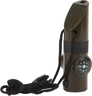
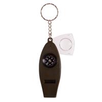
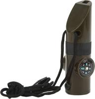
7 tools in one product: whistle, torch, compass, magnifying glass, thermometer, signalling mirror and storage container.This compass is the perfect item to take with you on your outdoor adventures. It has a cord so you can wear it around your neck and use it comfortably.Small and compact. Dimensions: 9.5 cm long and approx. 2.7 cm in diameter....

Verkopers met dit product

Verkoper
Bezorging
Prijs
echtveelvoorweinig.nl logo
echtveelvoorweinig.nl
2-3 werkdagen
6,99
4,42

Anderen bekeken ook

Reisgids Cruise Ports Northeast Asia | Lonely Planet
De nieuwste reisgidsen-serie van Lonely Planet: een luxe uitgave met als titel 'Cruise Ports ' waarin aandacht voor de belangrijkste niet te missen hoogtepunten van cruise bestemmingen. Ook hier wordt het kort en bondig geschreven met veel praktische informatie erbj als eten-drinken en vervoer. De lijst met accommodaties - zoals bij de gewone Planets - hebben ze weggelaten. Wel met veel plattegronden, kaartjes en rijkelijk geillustreerd met mooie foto's. Lonely Planet's Cruise Ports Northeast Asia is your passport to the most relevant, up-to-date advice on what to see and skip, and what hidden discoveries await you. Discover Nagasaki's vibrant charm, venture back to a time of samurai in Kakunodate, and relax on Okinawa's palm-fringed, sugar-white beaches - all with your trusted travel companion. Discover the best of Northeast Asia and begin your journey now! Inside Lonely Planet's Cruise Ports Northeast Asia: Full-colour maps and images throughout Highlights and itineraries help yo…
20,95
Wegenkaart - landkaart 3127 United States Northeast | National Geographic
Mooie kaart van de bekende kaartenmaker National Geographic. Veel details door kleurgebruik. De wegen zijn met kleuren verdeeld in drukke en minder drukke, de wegnummers zijn goed terug te vinden. De kaart onderscheidt zich van andere series door de hoeveelheid topografische details als counties, plaatsnamen en waterwegen en het bevat een register waarin het eenvoudig zoeken is. Daarnaast is de kaart gedrukt op scheur- en watervast papier. The United States Northeast Adventure Map will guide you through the states of the Mid Atlantic region (Virginia, West Virginia, Maryland, Delaware and Pennsylvania, New York and New Jersey) and New England (Connecticut, Rhode Island, Massachusetts, Vermont, New Hampshire, and Maine). Each of these states is rich in history and nature and has its own distinct character, from the dramatic rocky shoreline of Maine's Acadia National Park and the beaches and dunes of Cape Cod Massachusetts, through the Adirondack Mountains of New York, the White and Gre…
17,50
Wegenkaart - landkaart Sikkim & India Northeast | ITMB
Een degelijke kaart met aanduidingen van o.a. nationale parken, vliegveld, benzinepomp, dirt-roads en kleine plattegrond van Calcutta. Beschrijft de punt van India tussen Nepal en Buthan. De ene zijde van de kaart omvat Sikkim, schaal 1:135.000. De andere zijde van de kaart omvat Noordoost India, ten dele Nepal, Myanmar en China, schaal 1: 1.500.000. Kaart van Calcutta en Calcutta met omgeving.   Sikkim is an autonomous state between India and Chinese-controlled Tibet, much as Bhutan. It is a wonderful, mountainous country to visit, with reasonably good goads going far to the north, well into the Himalayas, and interesting temples/pagodas to see, as well as the fabulous Fam Rong Lho Wildlife Sanctuary. As anyone visiting this remote state needs to pass through the northeastern area of India to reach Sikkim, we have include a complete, detailed map of Bengal, Bihar, Meghalaya, and the Assam states as well as of the portion of Nepal abutting Sikkim, and an inset map of Kolkata. The map …
13,95
Wegenkaart - landkaart Bhutan & Northeast India | ITMB
Een degelijke kaart met aanduidingen van o.a. nationale parken, vliegveld, benzinepomp, dirt-roads en kleine plattegronden van Thimphu, Paro en Calcutta. Als overzichtskaart goed te gebruiken.   De ene kant van de kaart heeft Bhutan erop staan, met een schaal van 1:35.000. De andere kant van de kaart omvat noordoost India. Schaal 1:1.300.000    Bhutan is a beautiful mountainous country, squeezed between India and China. It is not a part of the world experiencing significant change, and this version is pretty much the same as our previous one, although updated with minor changes. Printed double-sided, with Northeast India on the other side.   Legend Includes: Roads by classification, Express Way, National Highway, Major Highway, Secondary Road, Other road/track, Railway, Ferry Route , State Boundary, Undefined Boundary, River and Lake, Glacier, Desert/ swamp, Mountain peak, Pass, Historical Site, Monument, Bhuddist Monument, Radio Tower, Post Office, Police Station, Hospital, Library, …
13,95

Klanten-reviews van COMPASS SOFTEE NORTHEAST

Er zijn nog geen beoordelingen voor dit productBen jij de eerste die een review plaatst?

Meer over COMPASS SOFTEE NORTHEAST

Productomschrijving

7 tools in one product: whistle, torch, compass, magnifying glass, thermometer, signalling mirror and storage container.This compass is the perfect item to take with you on your outdoor adventures. It has a cord so you can wear it around your neck and use it comfortably.Small and compact. Dimensions: 9.5 cm long and approx. 2.7 cm in diameter.

Productinformatie

    Productspecificaties

    Artikelnummer(s)
    EAN
    8445090147570
    Webshop.nl maakt gebruik van cookies. Ga je verder op onze website, ga dan akkoord met het plaatsen van cookies en de verwerking van deze data door ons en vermelde partners.