Campergids Where to Camp Guide Australia | Hema Maps

0
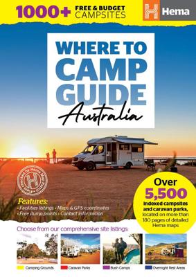
Prepare for your next adventure with the Where To Camp Guide from Hema, Australia’s premier producer of off-road and touring maps and guides. Prepared in collaboration with the CMCA, Australia's largest RV club, travellers can browse comprehensive site listings across all states and territories, or select sites along their path using detailed Hema...

Verkopers met dit product

Verkoper
Bezorging
Prijs
DeZwerver.nl logo
DeZwerver.nl
2,95
56,95

Anderen bekeken ook

Campergids Where to Camp Guide Australia | Hema Maps
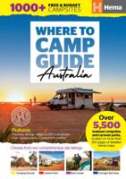
Prepare for your next adventure with the Where To Camp Guide from Hema, Australia’s premier producer of off-road and touring maps and guides. Prepared in collaboration with the CMCA, Australia's largest RV club, travellers can browse comprehensive site listings across all states and territories, or select sites along their path using detailed Hema maps. Listings are categorised as camping grounds, caravan parks, bush camps, and overnight rest areas, making it easy to find the perfect destination, while an intuitive design ensures stress-free trip planning.   Key Features   • Over 5,500 indexed sites, split into 75 regions • Site information and facilities • 180 pages of maps showing site locations • More than 1,000 free and budget sites • Free dump points • Intuitive, easy to use design • Camping and travel tips
56,95
Campergids Camps 12 Free Camping Guide without photos Spiral (A4) | Camps Australia Wide
SAVE YOU THOUSANDS - More focus on free+ low-cost sites than ever before   TRIP PLAN - Fold out map of Australia to plan and record your travels EASY TO USE - Spiral bound so it sits flat and you won’t lose your place STAY UP TO DATE  - Latest maps, NEW campsites and dump points YOU CAN FIND SITES QUICKLY - Map for each state is colour coded and an index for the country BONUS FREE 12 months access to the CAMPS Australia App SO EASY TO DECIDE WHERE TO STAY - See site type + pets allowed + public dump points on the maps and go to listings see facilities with our colourful symbols even swimming, fishing and more   EASY TO NAVIGATE - GPS co-ordinates + street address + directions if needed to your camp Aussie owned, over 30 years of research, 100% personally checked, you can TRUST what travellers call their FREE camping BIBLE    478 pages, spiral bound, soft cover, A4 size (29.7cm × 21cm), product of Australia   Discover hidden gems in every corner of Australia with Camps 12 - with more f…
82,50
Campergids Camps 12 Free Camping Guide Easy to Read with Photos Spiral Bound (B4) | Camps Australia Wide
Camps 12 is the only guide you will need for free and low-cost camping across Australia, featuring verified free and budget camps. Travellers can tell if a site is free or paid, national parks, state forests, showgrounds, pub stays, RV parks, stations and farm stays on the maps and listings. Only remote caravan parks that are important wayfinders or outback roadhouses are found in this streamlined edition.    What's new in Camps 12?   More focus on free and low-cost sites than ever before Latest new campsites and public dump points - over 3,300 pet-friendly campsites Supported with updates and free access to the CAMPS App Sites that are pet friendly and/or have a public dump point are identified on the map, as well as the listing How CAMPS is different to other guides? Known for generations as "The Traveller's Bible" Every site is personally checked You can see site type on the map with coloured icons 30 plus years of research Aussie family owned business Everything you nee…
102,95
Wegenkaart - landkaart Iconic Map Central Australia - Centraal Australië | Hema Maps
Detailkaart van een deel van Australië. Zeer goed leesbaar, met naast de topografische details veel symbolen waarmee allerhande toeristische zaken worden aangeduid als campsites, nationale parken, attracties, wandelmogelijkheden etc. This waterproof map of the Central Australia region is ideal for discovering some of Australia's most iconic landscapes. The main map covers the area around Alice Springs, including Uluru, Kata Tjuta, West MacDonnell Range, as well as the Simpson Desert and popular tracks such as the Canning Stock Route.   It also features additional information relating to permits, useful contacts and historical context surrounding some of the area's most popular tourist destinations.    PRODUCT FEATURES   GPS surveyed roads and tracks Fuel stops 4WD tracks Camping areas Historic sites Detailed inset maps
17,50
Campinggids Caravan Parks 6 Spiral (A4) | Camps Australia Wide
The only caravan park guide you will need for the whole of Australia!    Experience over 2,230+ of the very best caravan and tourist parks with Australia’s most comprehensive guide covering all states and holiday park networks, including over 1,890+ pet friendly sites included.   We’ve done all the hard work for you by checking, visiting and verifying every site so you can spend less time looking for the right spot and more time discovering Australia.   Presented in an easy-to-use format, with full colour images and easy to identify symbols, you can quickly compare facilities and price ranges at a glance, making your decisions easy!   Caravan Parks 6 includes:   Over 2,230+ caravan, RV & tourist parks across Australia Each site 100% verified by our team Latest edition HEMA maps with the sites overlaid Easy to read symbols to make identification of each site and its facilities easy Comprehensive information about each site including address and contact information, GPS location…
61,95
Wegenatlas Australia - Road en 4WD Atlas - Australie | Hema Maps
Gebonden versie, geen spriraalbinding leverbaar van deze atlas.  Schaal is variabel per kaart. Deze editie bevat meer kaarten dan ooit tevoren,met t verneiuwd klerugebruik en daardor nog beter leesbaar.. Met detailkaarten voor Australië's belangrijkstre 4WD bestemmingen: Cape York, Fraser Island, de Top End, de Kimberley, de Pilbara, Centraal-Australië, High Country Victoria en de Flinders Ranges. Zeer volledig met een handig coördinatenstelsel, afstandstabel, een gids voor de nationale parken, een lijst met geaccrediteerde informatiecentra en een volledige index zijn ook opgenomen om te helpen bij de planning extra excursies.  Featuring trusted Hema mapping for all of Australia, the perfect bound Hema Road & 4WD Atlas is the definitive travel guide for tourers and adventurers. Hema atlases feature more information useful to travellers, including 4WD tracks, campsites, caravan parks, rest areas, 24-hour fuel and points of interest.   The new edition contains more mapping than ever bef…
30,95
Wegenkaart - landkaart Explorer Map Mid West Western Australia - West Australië | Hema Maps
Mapping of Mid West Western Australia that has camping areas, national parks, fuel supplies and facility symbols marked on the map. On the reverse is region-specific touring information for Wildflower country, Goldfields, Batavia Coast, Geraldton to Kalbarri, Gascoyne and the Outback Coast, Carnarvon and the Blowhole Coast as well as the Great Eastern Highway, with detailed inset maps for Cape Range National Park, Kalbarri National Park, Francois Peron National Park, Kennedy Range National Park and Mount Augustus National Park also included.    Also featured are the Top 10 4WD Tracks, which include the Holland Track, Cave Hill Circuit, Jaurdi Station, Mount Elvire, Mundaring Powerlines Track, Stockyard Gully & Leseur National Park, Greenough River, Steep Point, Peron Peninsula and Kennedy Range National Park. Each track has a grading, map reference, permits and fees, distances, contact details, things to do and warnings.   Top 10 4WD Tracks Inset maps National parks Camping areas Fuel…
17,50
Wegenatlas Australië - Australia Road and 4WD Atlas - | Hema Maps
Deze wegenatlas (met ringband) is als volgt ingedeeld: in de omslag vindt u de legenda. Daarna volgt per staat een overzicht van de Nationale Parken en de voorzieningen. Aansluitend vindt u de wegenkaarten en stadsplattegronden per staat. Achterin de atlas een aparte sectie met kaarten voor de 4WD liefhebbers. Tot slot een afstandentabel.   Op de kaarten staan d.m.v. symbolen voorzieningen aangegeven zoals campings, 'lookouts', benzinestations, visitor information centers, picnic area enz.   Featuring trusted Hema mapping for all of Australia, the Hema Road & 4WD Atlas is the definitive travel guide for tourers and adventurers. Hema atlases feature more information useful to travellers, including 4WD tracks, campsites, caravan parks, rest areas, 24-hour fuel and points of interest.   This edition contains more mapping than ever before, which is enhanced by a striking new cartographic style that's incredibly easy to read. Included in this is up-to-date mapping for Australia's bigges…
40,95
Campinggids - Campergids Northern California Camping | Moon Travel Guides
De Amerikaanse uitgever Moon is een vergelijkbare gids met uitgever Lonely Planet > veel praktische informatie met veel diepgang! Het feit dat het een Amerikaanse uitgever is, maken deze gidsen zeer aantrekkelijk voor de staten en nabije landen afzonderlijk. De Lonely Planet haalt dat nivo niet! Whether you're camping among towering redwoods, along rugged coastline, or in the High Sierra, you'll always find your perfect campsite with Moon Northern California Camping. *A Campsite for Everyone: Pick the right tent or motorhome site with options ranging from secluded Sierra hike-ins to convenient roadside stopovers, including dog-friendly, family-friendly, and wheelchair accessible options, and strategic lists of the best campgrounds for hiking, swimming, and more*Ratings and Essentials: All campgrounds are rated on a scenic scale and marked with amenities like restrooms, trailhead access, picnic areas, laundry, piped water, showers, and playgrounds*Recreation Highlights: Discover nearby…
22,50

Klanten-reviews van Campergids Where to Camp Guide Australia | Hema Maps

Er zijn nog geen beoordelingen voor dit productBen jij de eerste die een review plaatst?

Meer over Campergids Where to Camp Guide Australia | Hema Maps

Productomschrijving

Prepare for your next adventure with the Where To Camp Guide from Hema, Australia’s premier producer of off-road and touring maps and guides. Prepared in collaboration with the CMCA, Australia's largest RV club, travellers can browse comprehensive site listings across all states and territories, or select sites along their path using detailed Hema maps. Listings are categorised as camping grounds, caravan parks, bush camps, and overnight rest areas, making it easy to find the perfect destination, while an intuitive design ensures stress-free trip planning.   Key Features   • Over 5,500 indexed sites, split into 75 regions • Site information and facilities • 180 pages of maps showing site locations • More than 1,000 free and budget sites • Free dump points • Intuitive, easy to use design • Camping and travel tips

Productinformatie

    Verken gerelateerde categorieën

    Webshop.nl maakt gebruik van cookies. Ga je verder op onze website, ga dan akkoord met het plaatsen van cookies en de verwerking van deze data door ons en vermelde partners.