webshop.nl
Categorieën
  Sluiten

Meer National Geographic
Meer National Geographic in Literatuur boeken

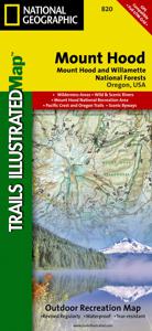
Wandelkaart - Topografische kaart 820 Mount Hood and Willamette Nation

0
Prachtige geplastificeerde kaart van het bekende nationaal park. Met alle recreatieve voorzieningen als campsites, maar ook met topografische details en wandelroutes ed. Door uitgekiend kleurgebruik zeer prettig in gebruik. Scheur en watervast! Located just outside of Portland, Mt. Hood is the tallest peak in Oregon, the fourth highest in the Casca...

Webshops met dit product

Webshop
Bezorging
Prijs

Anderen bekeken ook

Wandelkaart - Topografische kaart 821 Columbia River Gorge National Sc
Prachtige geplastificeerde kaart van het bekende nationaal park. Met alle recreatieve voorzieningen als campsites, maar ook met topografische details en wandelroutes ed. Door uitgekiend kleurgebruik zeer prettig in gebruik. Scheur en watervast! Considered one of the best year-round outdoor recreation areas in the country, the Columbia River Gorge contains countless opportunities for hikers, climbers, kayakers, cyclists, windsurfers, and winter sports enthusiasts alike. The 80 mile long gorge contains diverse ecosystems ranging from the lush Oneonta Gorge Rain Forest to the arid Celilo Grasslands.   Our detailed Trails Illustrated recreation map of the Columbia River Gorge contains carefully researched trails, campsites, forest service roads, and points-of-interests and adjoins our Mt. Hood map.   Backcountry users will find the UTM and Latitude/Longitude grids as well as other accurate navigation features perfect for exploring the region confidently and safely.   Areas included on the …
17,95
Wandelkaart - Topografische kaart 318 Mount Rogers High Country - Gray
Prachtige geplastificeerde kaart van het bekende nationaal park. Met alle recreatieve voorzieningen als campsites, maar ook met topografische details en wandelroutes ed. Door uitgekiend kleurgebruik zeer prettig in gebruik. Scheur en watervast!   National Geographic's Trails Illustrated map of Mount Rogers High Country and Grayson Highlands State Park, Southwest Virginia, is a two-sided, waterproof, topographic trail map designed to meet the needs of outdoor enthusiasts with unmatched durability and detail. This map was created in cooperation with local land management agencies and is loaded with valuable recreation information for exploring the area's large rock formations, spruce-fir forests, and the highest peak in Virginia. Trails and major roads, including the Appalachian Trail, the Virginia Creeper Trail, and the Virginia Highland Horse Trail, are clearly distinguished. Places of interest include areas for camping, picnicking, fishing, hiking, mountain biking, horseback riding, a…
17,95
Wandelkaart - Topografische kaart 263 Grand Canyon West | National Geo
Prachtige geplastificeerde kaart van het nationaal park. Met alle recreatieve voorzieningen als campsites, maar ook met topografische details en wandelroutes ed. Door uitgekiend kleurgebruik zeer prettig in gebruik. Scheur en watervast! National Geographic's Trails Illustrated map of Grand Canyon West covers some of the less frequented but just as wondrous landscape of Grand Canyon National Park, from Powell Plateau to the park's western boundary. Expertly researched and created in partnership with the National Park Service, U.S. Forest Service, Bureau of Land Management and others, the map also covers the surrounding areas of Kaibab National Forest, Hualapai Havasupai Indian Reservations and Parashant National Monument. With so much of the area being backcountry, the map also includes useful backcountry information, regulations and safety tips, in addition to a backcountry use area guide, color-coded by degree of experience required.   Clearly marked trails, including unmaintained pri…
16,95
Wandelkaart - Topografische kaart 257 Trails Illustrated Gates of the
Prachtige geplastificeerde kaart van het nationaal park. Met alle recreatieve voorzieningen als campsites, maar ook met topografische details en wandelroutes ed. Door uitgekiend kleurgebruik zeer prettig in gebruik. Scheur en watervast! Let National Geographic's Trails Illustrated map for Gates of the Arctic National Park and Preserve guide you on your adventure in this remote wilderness of northern Alaska. With neither roads or trails within the park, the map's contour lines, elevations, labeled peaks and summits, water features will be essential in your navigation of the area. Coverage includes many land and water points of interest within the park, as well as in neighboring areas, including the Brooks Range; Noatak, Alatna, John, Tinayguk and Koyukuk Wild and Scenic Rivers; Schwatka and Endicott Mountains; Yukon Flats and Kanuti National Wildlife Refuge Area; Noatak National Preserve; Walker Lake; Anaktuvuk Pass; and the Continental Divide. Also pinpointed are the area's bush airst…
16,95
Wandelkaart - Topografische kaart 747 Green Mountain National Forest N
Prachtige geplastificeerde kaart van het bekende nationaal park. Met alle recreatieve voorzieningen als campsites, maar ook met topografische details en wandelroutes ed. Door uitgekiend kleurgebruik zeer prettig in gebruik. Scheur en watervast! National Geographic's Green Mountain National Forest North Trails Illustrated topographic map is the most comprehensive available for outdoor enthusiasts of all types. Designed to be easy-to-read, yet highly detailed – this map includes a comprehensive road and trail network distinguishing between major, secondary and 4x4 roads, hiking, horse, biking, multi-use and non-motorized winter trails. All forest roads are labeled with their official road number and trails are clearly identified with their given name. Land management boundaries are color-coded showing National Forest, Ranger District, Wilderness Areas, Conservation Areas and more, plus the locations of private land within the Green Mountain National Forest. The renowned Appalachian Trail…
17,95

Klanten-reviews van Wandelkaart - Topografische kaart 820 Mount Hood and Willamette Nation

Er zijn nog geen beoordelingen voor dit productBen jij de eerste die een review plaatst?

Meer over Wandelkaart - Topografische kaart 820 Mount Hood and Willamette Nation

Productomschrijving

Prachtige geplastificeerde kaart van het bekende nationaal park. Met alle recreatieve voorzieningen als campsites, maar ook met topografische details en wandelroutes ed. Door uitgekiend kleurgebruik zeer prettig in gebruik. Scheur en watervast! Located just outside of Portland, Mt. Hood is the tallest peak in Oregon, the fourth highest in the Cascade Range, and a premier destination for outdoor enthusiasts. The mountain has six ski areas, the renowned Timberline Lodge located on the southern flank beside the Palmer Glacier, and is part of the 1.0M acre Mt. Hood National Forest.   Our detailed Trails Illustrated recreation map of Mt. Hood contains carefully researched trails, campsites, forest service roads, and points-of-interests.   Backcountry users will find the UTM and Latitude/Longitude grids as well as other accurate navigation features perfect for exploring the region confidently and safely.   Areas included on the map: - Badger Creek, Bull of the Woods, Mount Hood, and Salmon Huckleberry Wilderness Areas. - Newly Legislated Clackamas and Roaring River Wilderness Areas - Clackamas, Collawash, Elkhorn, Roaring River, South Fork Roaring River, White River, Salmon, Eagle Creek, Sandy River, and Fifteen Mile Creek Wild and Scenic Rivers - Pacific Crest and Oregon Trails - South Breitenbush National Scenic Trail - West Cascades and Mount Hood Scenic Byways - Mount Hood National Recreation Area - Opal Creek Scenic Recreation Area - Olallie Lake Scenic Area - Upper Big Bottom Special Protection Area - Oregon State Forests - Santiam and Timothy Lakes - Recreation, Safety, Contact and Wilderness Permit Information - Permit and Information for Climbing Mount Hood

Productspecificaties

Artikelnummer(s)
Brand
National Geographic

Verken gerelateerde categorieën

Webshop.nl maakt gebruik van cookies. Ga je verder op onze website, ga dan akkoord met het plaatsen van cookies en de verwerking van deze data door ons en vermelde partners.